I am trying to convert a walking route, which consists of little coloured balls in an Illustrator file, into a georeferenced line. Big problem is that that there is no attribute which sorts the order in which the balls are 'chained' to form the walking route.
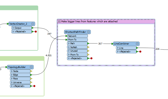
I have so far managed to:

- group the - to points converted - little balls per walking route

- clipped the OSM roads to the most relevant portions around the points

- converted From-To paths based on Neighbourfinder into segments that follow a topologically corrent roads network. The results you can see in the image below.
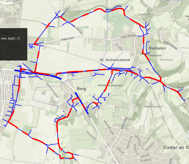
Blue lines form the underlying roads network, the red fragments are the results of the Linecombiner transformer. My problem is that:

  • in the last bit of the workflow I have combined features which are attached to each other into one line. As you can see in the first picture, the number of line features is reduced from 357 to 226, so thats good
  • however there are still red fragments that consist of multiple line features attached to each other, even after the Linecombiner.

I haven't found a difference in feature type or attributes that could explain the difference. Any suggestions are welcome.

Also any general remarks on how to build a lineroute from a set of points which have no inherent ordering attribute, are welcome.

Not an FME solution but I know you're using MAPublisher so if the original file is set up "right" this trick might work: there's the "Add Calculated Data" option in MAPublisher and one of the things it can do is consecutive numbering. If the original file has the little balls in the correct Illustrator order you can store that order in an attribute which can then be used in FME to sort on.

In fact, exporting from MAPublisher to a shapefile should retain that order too, so check that.

If the original file is not set up in a coherent way then you're out of luck I'm afraid. You can try using the Extender to add to your red segments and an AnchoredSnapper to snap them to the road network but you can't guarantee it'll snap to the right roads. No matter what you do there will be a need to do a manual check.

Another hybrid Illustrator/MAPublisher/FME approach that is a bit of a dirty hack but may just work:

  1. Change the symbol (they have used symbols, right?) to bigger circles, big enough for them to touch.
  2. Break link to symbol so they turn back into polygons
  3. Add anchor points enough times to approximate the polygons nicely (Illustrator circles are Bezier curves, GIS doesn't support that)
  4. Export to a shapefile
  5. Set up a workspace to use a Dissolver and CenterLineReplacer on the shapefile, then you may want to do a Densifier and AnchoredSnapper to make sure it snaps to the road network

Hope this helps.


Relate balls sections (if u have no ID per section) using a neigborfinder with a distance set to the average ball distance.

use a neighbourfinder with the balls as base and roadnetwork as candidate.

Cut the roadnetwork at closest candidates.

Extract startcoordinates of linepieces. Now u have order points per linepiece. Relate the ordernumber to linepiece.

Do same neighbourfinder as before.

Now order is transfered to your balls (no pun intended...)

Linejoiner per linepiece id yields connected balls (sections).

You may need to fiddle at complex situations.


Not an FME solution but I know you're using MAPublisher so if the original file is set up "right" this trick might work: there's the "Add Calculated Data" option in MAPublisher and one of the things it can do is consecutive numbering. If the original file has the little balls in the correct Illustrator order you can store that order in an attribute which can then be used in FME to sort on.

In fact, exporting from MAPublisher to a shapefile should retain that order too, so check that.

If the original file is not set up in a coherent way then you're out of luck I'm afraid. You can try using the Extender to add to your red segments and an AnchoredSnapper to snap them to the road network but you can't guarantee it'll snap to the right roads. No matter what you do there will be a need to do a manual check.

Another hybrid Illustrator/MAPublisher/FME approach that is a bit of a dirty hack but may just work:

  1. Change the symbol (they have used symbols, right?) to bigger circles, big enough for them to touch.
  2. Break link to symbol so they turn back into polygons
  3. Add anchor points enough times to approximate the polygons nicely (Illustrator circles are Bezier curves, GIS doesn't support that)
  4. Export to a shapefile
  5. Set up a workspace to use a Dissolver and CenterLineReplacer on the shapefile, then you may want to do a Densifier and AnchoredSnapper to make sure it snaps to the road network

Hope this helps.

Hi Hans, I did work with the Add Calculated Data, although not the numbering. I will check to see if that is workable. Otherwise - as I suspected - I am stuck...


Reply