Hi,

I have 2 input files:

  1. measured cross sections (consisting of points with x, y and z coordinates);
  2. predetermined cross sections (consisting of a couple of measurments, but can also be made into points or lines).

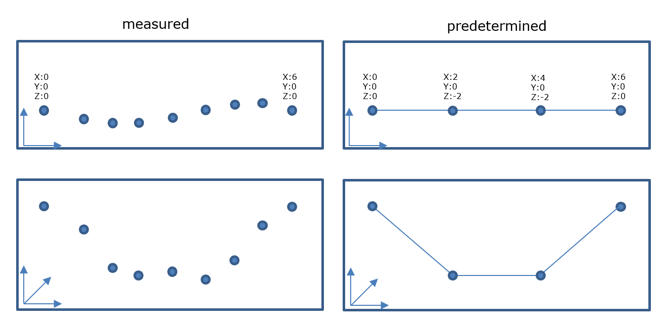
I want to compare the predetermined cs with the measured ones. The predetermined cs must completeley fit within the measured cs. I was thinking of making an area out of both cs, I can then shift the predetermined cs along the line (2D) and determine the best fitting position (starting form 0, then +0.5 m, +1.0 m and so on). However the measured cross sections cannot be made into an area suitable for comparing because the points vary and do not form a straight line (in 2D), the area's won't 'intersect' (see picture below). I was thinking of maybe using a neighborfinder to redirect het points into a straight line. Do you guys think this might work? Or should I go at it another way?

Michael

And ofcourse the picture. ( -_-')

And ofcourse the picture. ( -_-')

Hi @michael_pieters, in the screenshot, the start node (X=0, Y=0, Z=0) and end node (6, 0, 0) are common to the two datasets, though the 2D shapes are different between them. I therefore guess that the X values in both datasets indicate the measure value measured along the line. Is it right?

In other words, for example, does the point (X=1, Y=2, Z=3) in the 'measured' dataset match the point (1, 0, 3) in the 'predetermined' dataset, regardless of their Y values?


Hi @takashi that's correct. The predetermined cross sections constist only of x and z coordinates. The cross sections have to be alligned with the measured cross section (can do this with lineangle or something).


@michael_pieters, so then, I think it would be possible to compare them if you changed all Y values of the measured cs points to 0. e.g.

VertexCreator

  • Mode: Replace with Point
  • X Value: @XValue() <preserve original X>
  • Y Value: 0
  • Z Value: @ZValue() <preserve original Z>

Alternatively, this procedure is also possible

  1. CoordinateSwapper: Swap Type: Y <-> Z
  2. 3DForcer: Elevation: 0
  3. CoordinateSwapper: Swap Type: Y <-> Z

@takashi thanks for your input


Reply