Solved

Aggregator removing projections?

  • 26 April 2024
  • 2 replies
  • 40 views

Badge +1

Hello everyone,

I am trying to write data into an SQL Database which contains multiple geometries (This is borehole location data containing the originaly measured location (point), a corrected location (point) an a borehole path (linestring)). After creating the geometries from fields and using a GeometryPropertySetter for each of these geometries I am using an Aggregator followed by a MultipleGeometrySetter-Transformer. This is working more or less as in 3 Geometries are in fact written into the database which then also contains 3 fields with SQL geometries as set by the 3 GeometryPropertySetters. 

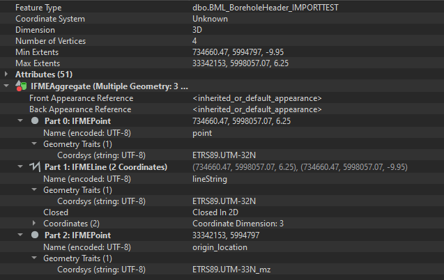
But there seems to be a problem. Between setting the individual geometries and aggregation, all info on the previously set projections seems to be lost. Upon inspecting each individual GeometryPropertySetter all points are where they should be. Inspecting the following aggregator shows all points off bounds somewhere. It is my understanding that the aggregator should simply collect the input data but not change anything. 

Does anyone has any ideas what could be going on here?

Thanks.

icon

Best answer by pkno 30 April 2024, 08:31

View original

2 replies

Userlevel 1
Badge +9

Hello, @pkno.

After reviewing your question, I would like to request additional information that will help troubleshoot more effectively. If you are comfortable, could you kindly provide the following details if possible?

- The version of FME you are using, including the build number and edition.
- A sample of your data or screenshots of the data in FME Form.
- Your FME translation log file.
- Any other information you think might be useful to share.

My thought is that an incorrect parameter may have been set when building your workspace?

Badge +1

Hello @AliAtSafe,

thanks for replying. I believe I already found a solution to my problem. After writing the Coordsys-Trait SQLServer recognizes the coordinate systems in the written data. Its also there when reading the database back into FME, even though the Coordinate System field now states “Unknown”, all the Geometry Traits are there and correct : 

I couldnt find a way to easily read the aggregate geometries into ArcGIS or QGIS but I suspect thats because these specifically look into the Coordinate System field and are looking for a single geometry type but thats a problem I would have to solve from that end rather than FME. Thats of secondary importance though, so I think this is solved.  

Reply