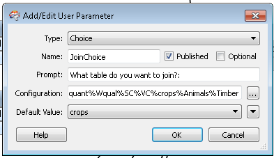
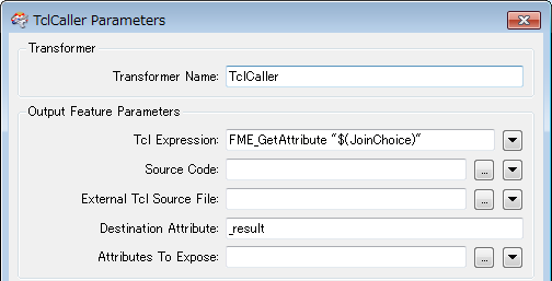
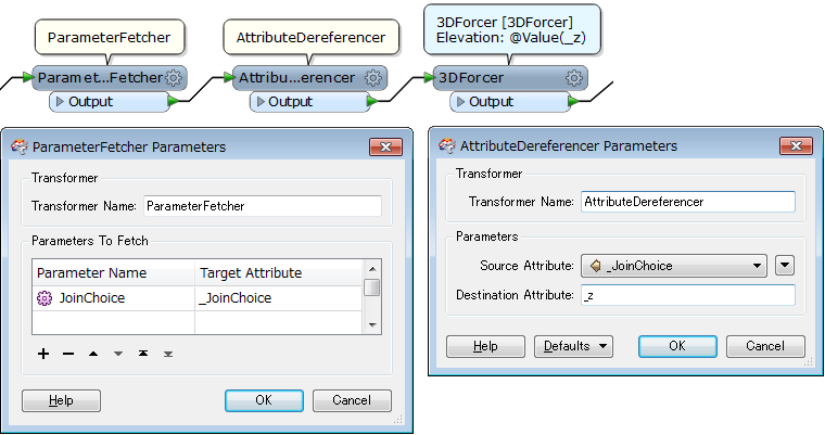
I'm creating a work bench to turn a polygon dataset into a raster and then adds it to various existing rasters. I want to use a parameter so I only need to create one workspace and the user can select which raster they want to use for the addition. I've created the parameter with a drop down list for options.
Firstly, I'm using a Joiner to add a spreadsheet to the dataset which contains 7 fields and those fields match the options in the parameter and the 'fields to add' variable is set to my parameter value, so far this stage works.
The problem occurs in the next step where I have the 3D Forcer. I have the elevation variable set to my parameter but when I run it I get the following error: 2014-12-29 10:13:36| 0.6| 0.0|WARN |3DForcer_2: Failed to evaluate TCL expression: crops
2014-12-29 10:13:36| 0.6| 0.0|WARN |3DForcer_2: TCL Error Message: invalid bareword "crops"
in expression "crops";
should be "$crops" or "{crops}" or "crops(...)" or ...
2014-12-29 10:13:36| 0.6| 0.0|STATS |Storing feature(s) to FME feature store file `S:\\fme _work\\SBC\\PolytoRastTool/AllTest_log.ffs'
2014-12-29 10:13:36| 0.6| 0.0|ERROR |+++++++++++++++++++++++++++++++++++++++++++++++++++++++++++++++++++++++++++
2014-12-29 10:13:36| 0.6| 0.0|ERROR |Feature Type: `3DForcer_2_OUTPUT'
2014-12-29 10:13:36| 0.6| 0.0|ERROR |Attribute(string) : `HabClass' has value `Intact hedge'
2014-12-29 10:13:36| 0.6| 0.0|ERROR |Attribute(string) : `SHAPE_GEOMETRY' has value `shape_polygon'
2014-12-29 10:13:36| 0.6| 0.0|ERROR |Attribute(string) : `_JoinChoice' has value `crops'
2014-12-29 10:13:36| 0.6| 0.0|ERROR |Attribute(32 bit unsigned integer): `_matched_records' has value `1'
2014-12-29 10:13:36| 0.6| 0.0|ERROR |Attribute(string) : `crops' has value `100'
2014-12-29 10:13:36| 0.6| 0.0|ERROR |Attribute(string) : `fme_basename' has value `HabitatLayer'
2014-12-29 10:13:36| 0.6| 0.0|ERROR |Attribute(string) : `fme_dataset' has value `E:\\Projects\\Matt\\SBC\\Update_Tool\\HabitatLayer.shp'
2014-12-29 10:13:36| 0.6| 0.0|ERROR |Attribute(string) : `fme_feature_type' has value `HabitatLayer'
2014-12-29 10:13:36| 0.6| 0.0|ERROR |Attribute(string) : `fme_geometry' has value `fme_polygon'
2014-12-29 10:13:36| 0.6| 0.0|ERROR |Attribute(entangled: string) : `fme_type' has value `fme_area'
2014-12-29 10:13:36| 0.6| 0.0|ERROR | entangled to [SHAPE_GEOMETRY]
2014-12-29 10:13:36| 0.6| 0.0|ERROR |Attribute(32 bit integer) : `multi_reader_full_id' has value `0'
2014-12-29 10:13:36| 0.6| 0.0|ERROR |Attribute(32 bit integer) : `multi_reader_id' has value `0'
2014-12-29 10:13:36| 0.6| 0.0|ERROR |Attribute(string) : `multi_reader_keyword' has value `SHAPE_1'
2014-12-29 10:13:36| 0.6| 0.0|ERROR |Attribute(string) : `multi_reader_type' has value `SHAPE'
2014-12-29 10:13:36| 0.6| 0.0|ERROR |Coordinate System: `BritishNatGrid'
2014-12-29 10:13:36| 0.6| 0.0|ERROR |Geometry Type: IFMEPolygon
2014-12-29 10:13:36| 0.6| 0.0|ERROR |Boundary:
2014-12-29 10:13:36| 0.6| 0.0|ERROR | Geometry Type: IFMELine
2014-12-29 10:13:36| 0.6| 0.0|ERROR | Number of Coordinates: 36 -- Coordinate Dimension: 2
2014-12-29 10:13:36| 0.6| 0.0|ERROR | (349569.207114486,589619.939759698)(349571.239999999,589616.689500002)(349568.139999998,589614.09)(349563.415,589610.265000001)(349558.039999998,589606.289999999)
2014-12-29 10:13:36| 0.6| 0.0|ERROR | (349552.6125,589602.978000002)(349546.941743891,589598.486077951)(349544.306699998,589604.373999999)(349537.801299999,589600.579199999)(349532.306699999,589597.374)
2014-12-29 10:13:36| 0.6| 0.0|ERROR | ...Skipping coordinates...
2014-12-29 10:13:36| 0.6| 0.0|ERROR | (349509.376720743,589614.411194774)(349514.18394296,589617.132493654)(349521.293849998,589620.653300001)(349528.4067,589621.313999998)(349535.126699999,589621.915599999)
2014-12-29 10:13:36| 0.6| 0.0|ERROR | (349541.385900001,589621.5764)(349546.716243719,589620.73925744)(349553.614149999,589618.5648)(349557.630447912,589618.522411076)(349564.675239373,589618.294556824)
2014-12-29 10:13:36| 0.6| 0.0|ERROR | (349569.207114486,589619.939759698)
2014-12-29 10:13:36| 0.6| 0.0|ERROR |===========================================================================
2014-12-29 10:13:36| 0.6| 0.0|ERROR |3DForcer_2: ZValue function cannot convert 'crops' to floating point value
2014-12-29 10:13:36| 0.6| 0.0|WARN |3DForcer_2: Failed to evaluate TCL expression: crops
2014-12-29 10:13:36| 0.6| 0.0|WARN |3DForcer_2: TCL Error Message: invalid bareword "crops"
in expression "crops";
should be "$crops" or "{crops}" or "crops(...)" or ...
Before creating the parameter and haven't the values hard coded it worked perfectly fine. If anybody has any work arounds for this then it would be greatly appreciated!
Thank you


