Question

Non-spatial features into a shapefile


Badge +11
Hi all,


Could someone tell me how can I put non-spatial features into a shapefile?


Here is an screenshot:


(as you can see, with inspector they are found 4 features, but once I check the Shapefile, there are just writen two features)


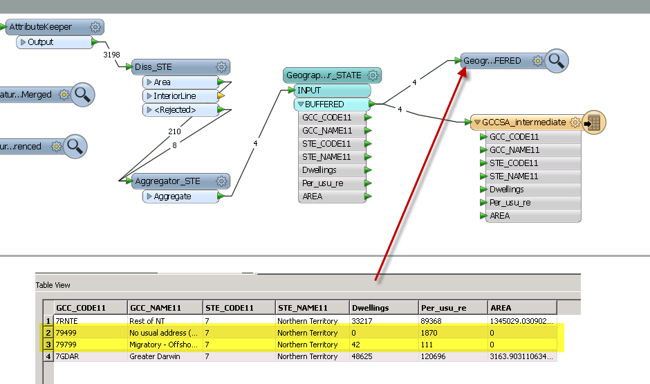
Note: the original Shapefile has spatial and non-spatial features inside.


Many thanks,


JuanM.

5 replies

Badge +11
I'd like to add to my question above that I tried to extract (if possible) _x and _y coordinates with "CoordinateExtractor" in a .csv file and there is NO possibilities of positioning this features in a map:


And here is what I have from the original shapefile:(highlighted those non-spatial features)


Thanks,


JuanM.
Userlevel 2
Badge +17
Hi,


In my quick test, the Shape writer was able to write the features that have no geometry without any problem.


Did you check the log? If there were some warning messages in the log, those might help us to know what's going on.


Takashi
Badge +11
Thanks @Takashi I'll try to see what's behind the log file.


JuanM.
Badge +11
Hi again,


Thanks @Takashi for your tip, but there is no option to write this kind of feautures: it rejects them:


08 08:21:36| 37.6| 0.0|WARN |Polygon feature must have at least 4 coordinates...rejecting08 08:21:36| 37.6| 0.0|WARN |REJECTING BELOW FEATURE:


08 08:21:36| 37.6| 0.0|INFORM|+++++++++++++++++++++++++++++++++++++++++++++++++++++++++++++++++++++++++++


08 08:21:36| 37.6| 0.0|INFORM|Feature Type: `GCCSA_intermediate'


08 08:21:36| 37.6| 0.0|INFORM|Attribute(64 bit real) : `AREA' has value `0'


08 08:21:36| 37.6| 0.0|INFORM|Attribute(64 bit real) : `Dwellings' has value `42'


08 08:21:36| 37.6| 0.0|INFORM|Attribute(encoded: windows-1250): `GCC_CODE11' has value `79799'


08 08:21:36| 37.6| 0.0|INFORM|Attribute(encoded: windows-1250): `GCC_NAME11' has value `Migratory - Offshore - Shipping (NT)'


08 08:21:36| 37.6| 0.0|INFORM|Attribute(64 bit real) : `Per_usu_re' has value `111'


08 08:21:36| 37.6| 0.0|INFORM|Attribute(encoded: windows-1250): `STE_CODE11' has value `7'


08 08:21:36| 37.6| 0.0|INFORM|Attribute(encoded: windows-1250): `STE_NAME11' has value `Northern Territory'


08 08:21:36| 37.6| 0.0|INFORM|Attribute(string) : `fme_basename' has value `MB_2011_added_INFO'


08 08:21:36| 37.6| 0.0|INFORM|Attribute(string) : `fme_dataset' has value `J:\\Analysis\\Census\\Australia\\3_Int\\01_MB_with_metadata\\MB_2011_added_INFO.shp'


08 08:21:36| 37.6| 0.0|INFORM|Attribute(string) : `fme_feature_type' has value `MB_2011_added_INFO'


08 08:21:36| 37.6| 0.0|INFORM|Attribute(string) : `fme_geometry' has value `fme_aggregate'


08 08:21:36| 37.6| 0.0|INFORM|Attribute(string) : `fme_rejection_code' has value `AREA_REQUIRED'


08 08:21:36| 37.6| 0.0|INFORM|Attribute(entangled: string) : `fme_type' has value `fme_area'


08 08:21:36| 37.6| 0.0|INFORM| entangled to [SHAPE_GEOMETRY, SHAPE_GEOMETRY]


08 08:21:36| 37.6| 0.0|INFORM|Attribute(string) : `multi_writer_id' has value `0'


08 08:21:36| 37.6| 0.0|INFORM|Coordinate System: `_LL-GDA94_0'


08 08:21:36| 37.6| 0.0|INFORM|Geometry Type: IFMEMultiArea


08 08:21:36| 37.6| 0.0|INFORM|Number of Areas: 0


I also tried with types:
  • Polygonm
  • Polygonz


Any other ideas?


JuanM.
Badge +11
Many thanks!! Removing the geometry give the chance to FME to add the non-spatial features inside (in this case) to a polygon shapefile.


Thanks Takashi!


;)


JuanM.

Reply