Solved

GeoSpatial Pdf Unsupported Projection

  • 10 August 2018
  • 8 replies
  • 5 views

Userlevel 6
Badge +33

When reading features from a GeoSpatial PDF created by ArcMap, CRS EPSG:28992, I get the following warning in the log:

Unsupported projection provided; Using Non-Earth projection instead

The result is shifted 117 meters north north east.
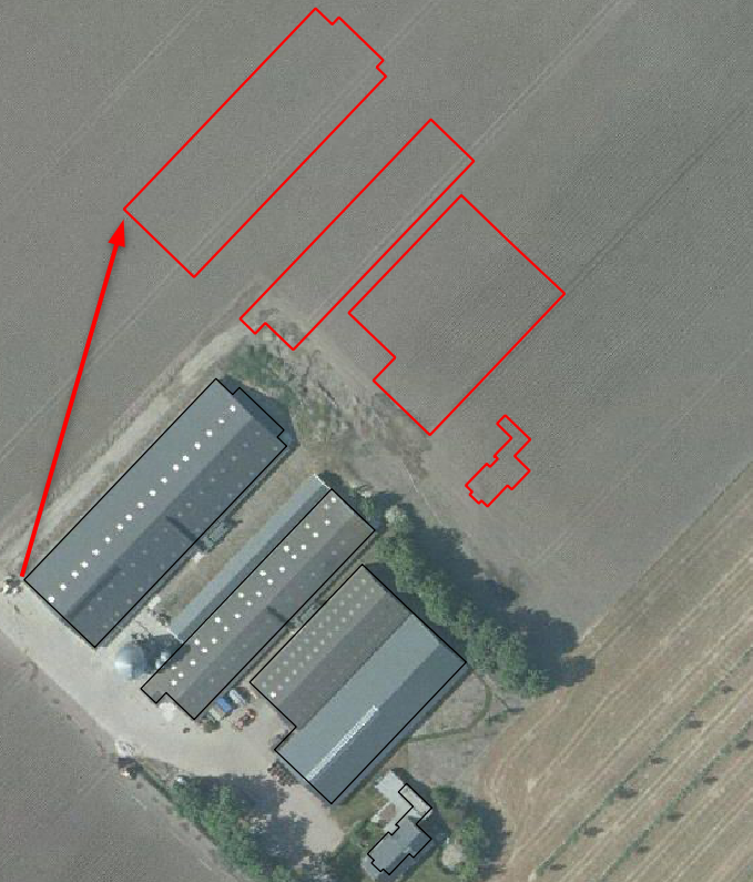
0684Q00000ArDYfQAN.png

Checked the CRS of the frame:

pdf_frame_coordinate_system: _Netherlands-RDNew-2008_0

In the Coordinate System Gallery this CRS is known under the names:


- Netherlands-RDNew-2008


- EPSG:28992

Is the underscore in the pdf_frame_coordinate_system causing the problem?

icon

Best answer by xiaomengatsafe 14 August 2018, 01:33

View original

8 replies

Userlevel 5
Badge +25

For what it's worth: I've opened the PDF in Avenza MAPublisher, which reported there was shearing in the document. Added the BAG WFS for reference which shows a much smaller error (50 cm) in the other direction.

I know it's not an answer but maybe it's useful information to try and figure out what is going on.

Userlevel 6
Badge +33

For what it's worth: I've opened the PDF in Avenza MAPublisher, which reported there was shearing in the document. Added the BAG WFS for reference which shows a much smaller error (50 cm) in the other direction.

I know it's not an answer but maybe it's useful information to try and figure out what is going on.

Thanks for checking. Not sure what shearing means in this context?
Userlevel 5
Badge +25
Thanks for checking. Not sure what shearing means in this context?
That would be a parrallellogram distortion, i.e. x and y axis not quite at a 90 degree angle to eachother.


Badge +2

Hi @nielsgerrits, Thanks for letting us know of this issue. Our developers did some investigation and found out the source of this problem. We will be working to fix it, and update you here, when the fix is ready in a beta.

Thanks again for reporting this to us!

Xiaomeng

Userlevel 6
Badge +33

Hi @nielsgerrits, Thanks for letting us know of this issue. Our developers did some investigation and found out the source of this problem. We will be working to fix it, and update you here, when the fix is ready in a beta.

Thanks again for reporting this to us!

Xiaomeng

Appreciate the feedback, happy to help improve the software.
Badge
Appreciate the feedback, happy to help improve the software.
I'll just add that I really appreciate the small, targeted repro package you put together here. It really helped illustrate the exact cause of this issue. We had some glimpses of it before, but could never pin down the root of the problem.


In case you're interested, it had to do with potentially incorrect datum/ellipsoid transformations on the control points for the map frame in the PDF. Often it would be accidentally-correct (or very close), which let the bug fly under our radar for quite a while (it was easy to attribute these very small errors to lack of fidelity/precision in the PDF). Luckily, your Dutch datum was different enough to demonstrate a clear problem.


Userlevel 6
Badge +33
Appreciate the feedback, happy to help improve the software.
Nice to get this feedback @jakemolnar. Motivates to keep doing it this way. Did some bug fixing in a previous job and experienced how hard reproducing an error can be.
Badge +2

Update: @nielsgerrits. Good news, This issue should be fixed now, in our latest 2018.1 download. Please give it a try, when you get a chance, and let us know if we can help any further. Thanks again, for reporting the issue, and the repro package!

Reply