Question

How to extract attributes from pdf


Badge +4

Hi

i am trying to extract attributes from a pdf (marked in the screenshot)

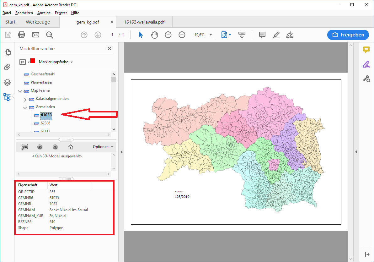
In the inspector i see in the attribute pdf_all_layer_names 2 layer (Map Frame, Gemeinde) but not de Number and the Attributes. I also tried to expose additional attributes, but i didn't find the attributes, which are in the red box.

i am using FME2019.1


5 replies

Badge +22

I can't figure out how to access the model tree on the pdf reader either.


If all you need are the attributes (as opposed to the geometry associated with them) in acrobat you can export it as xml, which FME can then read.
Badge +4

I can't figure out how to access the model tree on the pdf reader either.


If all you need are the attributes (as opposed to the geometry associated with them) in acrobat you can export it as xml, which FME can then read.

What a pity. I need it in an automated workflow. I tried to to export the xml with python, but i was not successfull. It would be great if there was some script or commandline tool to export it as xml to integrate it in FME

Badge +6

I dont know the solution but i know where you can find the data you need.

1.(http://data.steiermark.at/cms/beitrag/11822084/97108894/?AppInt_OGD_ID=4 ->

orders of political communities as GIS areasTitelMunicipal boundaries Styria


Description


Format: shp


Link: Download Shapefile 2016 (Koordinatensystem ETRS89/WGS84)


Sprache: ger, Characterset: ISO-8859-1, Größe(Bytes): 7169000, Veröffentlichung: 01.01.94, Änderung: 01.01.19

2. https://www.data.gv.at/katalog/dataset/verwaltungsgrenzen-vgd-stichtagsdaten-steiermark/resource/b33eb763-ce89-403c-8dfe-026c4ba52283

-> Data:

http://www.bev.gv.at/pls/portal/docs/PAGE/BEV_PORTAL_CONTENT_ALLGEMEIN/0200_PRODUKTE/UNENTGELTLICHE_PRODUKTE_DES_BEV/VGD-Steiermark.zip


Badge +4

I dont know the solution but i know where you can find the data you need.

1.(http://data.steiermark.at/cms/beitrag/11822084/97108894/?AppInt_OGD_ID=4 ->

orders of political communities as GIS areasTitelMunicipal boundaries Styria


Description


Format: shp


Link: Download Shapefile 2016 (Koordinatensystem ETRS89/WGS84)


Sprache: ger, Characterset: ISO-8859-1, Größe(Bytes): 7169000, Veröffentlichung: 01.01.94, Änderung: 01.01.19

2. https://www.data.gv.at/katalog/dataset/verwaltungsgrenzen-vgd-stichtagsdaten-steiermark/resource/b33eb763-ce89-403c-8dfe-026c4ba52283

-> Data:

http://www.bev.gv.at/pls/portal/docs/PAGE/BEV_PORTAL_CONTENT_ALLGEMEIN/0200_PRODUKTE/UNENTGELTLICHE_PRODUKTE_DES_BEV/VGD-Steiermark.zip


Hi very kind of you. But the pdf was just a example made from this data ;) we need it for a different pdf so i posted one with a simple schema

Badge +4

I found out the problem was caused by the pdf itself. I exported the map as pdf with ArcMap and now FME can read it - every municipality has its attributes. The attached pdf was exported by a co-worker with ArcGISPro. I tried it now by myself with ArcGISPro and now it's even there working. Only problem - there is a irregular offset from the pdf to the original data.


Reply