

I'm evaluating the product and it seems promising, but I'm having a hard time trying to determine if we could use it to take Revit files and convert them to 2D GIS floor plans (like what you see on Google maps with indoor maps for rooms and such). It would be SHP or KML, and I can get from Revit 2017 to IFC, but it doesn't seem to let me convert 3D to 2D content (like rooms). Is this possible with the product?
The goal is to make indoor Google maps like you see in an airport or mall based on rooms and features from a Revit model.
This came from FME support via e-mail:
The Revit reader in FME allows you to choose a Data View, which filters the Revit data in order to make it more manageable. One of the available Data Views is Building Floor Plan, which produces a 2D floor plan of the building, rather than a 3D model.
In order to read the Revit data in FME, you must first install the FME Exporter plugin in Revit. This is done automatically if you install FME on the same computer as Revit (and install the same 32bit/64bit version). However, we also offer the plugin as a free standalone download from "https://www.safe.com/solutions/for-applications/autodesk/revit/download/".
Once the plugin is installed in Revit, you can run it using the instructions shown at "https://knowledge.safe.com/articles/597/how-to-use-fme-exporter-for-revit.html".
The Revit reader will also read IFC files, but there are some settings on the FME Exporter that allow you include the 2D representations of objects like doors, which will improve the appearance of the floorplan.
Hi,
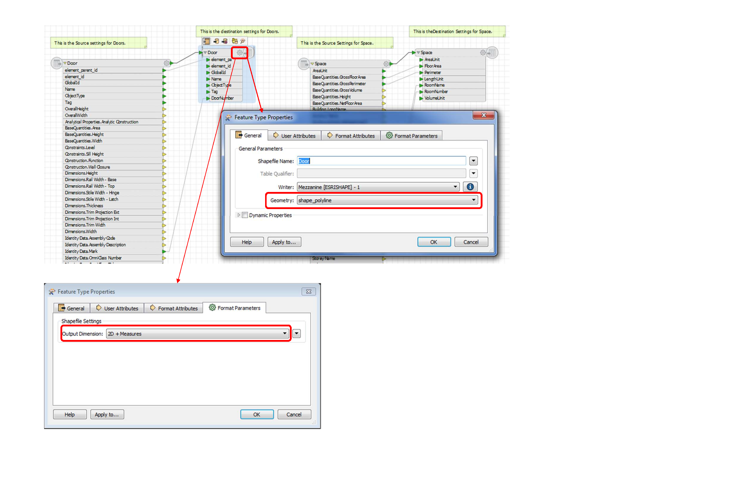
I don't know if you have figured this out, but there are some undocumented steps to do this.
First, I'd suggest, if you are transforming a multi-level Revit model, to export each level, from plan view, individually with the FME Revit Exporter plugin. Then, in FME, read in the RVZ file and revit elements. For every Feature Type Properties of the Writer (to Esrishape), in the General tab, set Geometry to shape_polyline and in the Format Parameters tab, set Output Dimension to 2D + Measures. That is really all that I had to do to get it from 3d to 2d and consumed in ArcGIS. I'd be more than happy to help if you have any questions.
Reply
Enter your username or e-mail address. We'll send you an e-mail with instructions to reset your password.