Question

Translating a polygon from .poly (Osmosis polygon format)

  • July 29, 2013
  • 4 replies
  • 125 views

fme4fsj
Contributor
Forum|alt.badge.img
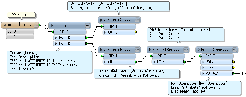
I have an Osmosis .poly file that I wold like to translate to a shape file.  It is fairly simply formatted as a text list (see below) but I am having difficulty associating the Polygone number (first line) with the list of coordinates.  This seems like it should be really simple but I've tried several text to csv transformers and I can not get the Polygon number to be an attribute of every coordinate.  I was trying that so I could use it as the "Connection break attribute" on  POINT CONNECTOR, to connect the dots to build my polygon.  Am I on the wrong track? 


Text data format:


76


    9.71250000000003  54.4940260000001


    9.71416700000003  54.493474


    9.71361300000007  54.4931940000001


    9.71416700000003  54.4920840000001


    9.71027800000007  54.4926380000001


    9.71083400000003  54.4937520000001


    9.71250000000003  54.4940260000001


END


Any pointers or hints would be appreciated.
This post is closed to further activity.
It may be an old question, an answered question, an implemented idea, or a notification-only post.
Please check post dates before relying on any information in a question or answer.
For follow-up or related questions, please post a new question or idea.
If there is a genuine update to be made, please contact us and request that the post is reopened.

4 replies

takashi
Celebrity
  • July 30, 2013
Hi,


The VariableSetter / VariableRetriever can be used to add the polygon ID to each point. If the polygon ID always occurs at the first line in the block of a polygon data lines and also the second column of the ID line is empty, one possible workflow is like this:


Alternatively a PythonCaller also can be used. For example:


-----


import fmeobjects   class OsmosisPolygonCreator(object):     def __init__(self):         self.polygon_id = None         self.coords = []              def input(self, feature):         x = feature.getAttribute('col0')         y = feature.getAttribute('col1')         if x == 'END':             boundary = fmeobjects.FMELine(self.coords)             polygon = fmeobjects.FMEPolygon(boundary)             feature.setGeometry(polygon)             feature.setAttribute('polygon_id', self.polygon_id)             self.pyoutput(feature)             self.coords = []         elif not y or y == '':             self.polygon_id = x         else:             self.coords.append((float(x), float(y)))              def close(self):         pass


-----


  The results of these 2 ways are almost same, but the 2DPointReplacer seems to round the coordinate value by certain precision. I think the Python script is effective if necessary to keep precision.


Takashi

fme4fsj
Contributor
Forum|alt.badge.img
  • Author
  • Contributor
  • July 30, 2013
Hi Takashi,


Yes I see.  I had most of the components but for the initial tester, where you are testing col1 for null or blank values, I was trying to test col0 for non-decimal numbers (in contrast to the decimal degree, coordinates).  I gave up because I couldn't find a way to do that.  Well,  I hadn't thought of Variable Setter/Retriever either :). 


Thanks for giving me another way to look at it.


-FSJ

takashi
Celebrity
  • July 30, 2013
Hi,


It's possible to test whether the attribute value is a number of a decimal point or not: Left Value: col0 Operator: Matches Regex Right Value (Regular expression): [0-9]*\\.[0-9]*   In addition, Multiple Feature Attribute Support functionality of the AttributeCreator (FME 2013 SP2) could be also used instead of the VariableSetter / VariableRetriever. There are several ways to do same thing in many cases :-)


Takashi

fme4fsj
Contributor
Forum|alt.badge.img
  • Author
  • Contributor
  • August 16, 2013
Thank you Takashi the regex and attribute retriever worked great.