
Hi, I'm using FME to build an ESRI REST service call to solve a routing problem.
We need to route 1500 properties into 15 routes every day, each route has a capacity of 100 visits (orders in ESRI terminology).
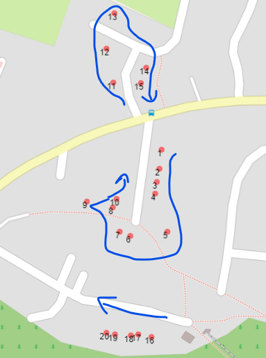
Occasionally ESRI snaps the lat/lon of the property to the wrong street so the sequence of the route is wrong.
In the image property 1 is actually on the same street as properties 11-14 and property 15 is actually on the same street as properties 2-10.
I need to 'move' the properties to the correct street. They still need to be on the correct side of the street as we need to maintain left hand curb approach ie to prevent having to cross the road (less of an issue with these small streets but the routes cover rural to urban streets).
Does anyone have any ideas how to achieve this?
I have access to a street centre line layer as well as the property points.
many thanks

 I'm likely to process our 250k properties so we can just join the property route locations based on our property reference as this will reduce the load and time taken to process the daily routes.