Question

Raster Mosaicker keep full extent

  • June 9, 2020
  • 2 replies
  • 20 views

oliver.morris
Contributor
Forum|alt.badge.img+14

Hi, I have two inputs to a raster mosaicker and would like them to retain the full extends of the combination of the two inputs yet is doesnt seem to:


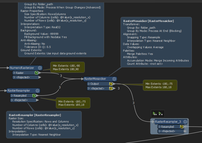
I basically want to have a nice -180,-90,180,90 geotiff. any gaps from the bottom raster input needs to be filled with no data (coming from the top input). Any idea why the RasterMosaicker isnt doing this.

Thank you very much for your help in advance.

Oliver


This post is closed to further activity.
It may be an old question, an answered question, an implemented idea, or a notification-only post.
Please check post dates before relying on any information in a question or answer.
For follow-up or related questions, please post a new question or idea.
If there is a genuine update to be made, please contact us and request that the post is reopened.

2 replies

jdh
Contributor
Forum|alt.badge.img+37
  • Contributor
  • 2002 replies
  • June 9, 2020

Your second stream of rasters are being rejected, which means there is a compatibility issue.

This is generally due to the bands not being the same interpretation, or coordinate system but there will be an error message on the rejected features saying what the issue is.


oliver.morris
Contributor
Forum|alt.badge.img+14
  • Author
  • Contributor
  • 176 replies
  • June 9, 2020

Your second stream of rasters are being rejected, which means there is a compatibility issue.

This is generally due to the bands not being the same interpretation, or coordinate system but there will be an error message on the rejected features saying what the issue is.

Thank you I don't know how I missed that coming out to rejection port, I will give it a check and go from there, thanks again.