I'm trying to work out what's going on here.
I have a series of lines in WGS84. I run them through this process:
LengthCalculator -> Reprojector (to _AZMED_) -> LengthCalculator.
This gives me two lengths for each line, one in WGS84 "units" (meaningless themselves), the other in _AZMED_ units (metres I think).
I expect the absolute values of these lengths to be different, but the relative values to be the same (i.e. that I can sort by either length column, and that the order will remain unchanged).
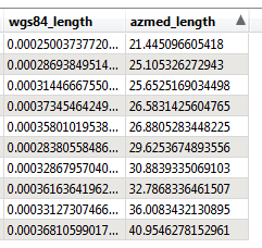
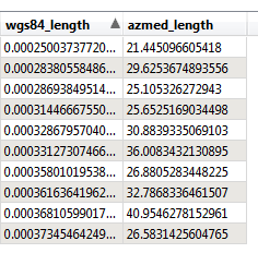
However this isn't the case - the relative values are different.
Sorted by Azmed you see:

Sorted by WGS84, it's obvious that the azmed order is different.

However this doesn't seem to happen with polygons and the AZMEA projection - their sort order seems to remain consistent.
So the question - what quirk of projections am I missing? Which distance is "correct"? I know that different projections have different traits, but I didn't expect the WGS84/AZMED change to alter results so drastically for distances that are so similar.
Thoughts welcome.
Thanks,
Jonathan


