Solved

how to go from geotif to ecw without black borders

  • June 15, 2020
  • 2 replies
  • 74 views

koenvdw
Contributor
Forum|alt.badge.img+6

Hi all


After processing we are left with ortho tiles in GEOTIFF format.

The GEOTIFFS on the edge of the process area have black borders.

When we process to area's next to eachother we have an overlap with the black borders.


Normally we work with jpeg2000 and I use the rasterbandnodatasetter and the rasterinterpretationcoercer to convert the nodata to an alpha band.


But now our client wants the orthophoto tiled with their specifiactions and in ECW.


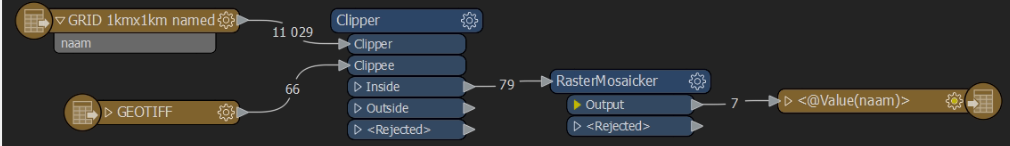
This is my tiling workbench. Pretty easy. The rastermosaicker groups by "naam" and puts out ECW tiles.


The result looks like this:

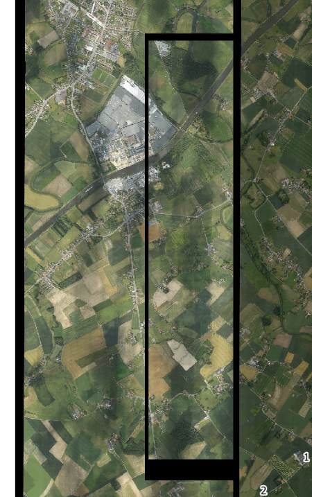
As you can see there are black borders in the area's that overlap.

What I understand is that ECW wont work with nodata and wont work with alpha band.


How can I solve this?


I could convert the original geotiff files to tiff with the nodata and rasterbandinterpretation method.

Once I have them I can tile them with my workbench but use a tiff writer instead of an ECW writer.

After I have my tiff tiles I can convert them to ECW.


This looks so much work. Not very efficient, not very FME like...

Is there a better way?


Best answer by jdh

Prior to the Clipper, use a RasterBandNoDataSetter (0) on the geotiffs. In the RasterMosaicker make sure NoData Overwrites Data is set to No, Ovelapping values is set to anything other than composite with Alpha channel (I generally use last) After the mosaicker use a RasterBandNoDataRemover.

No need to involve alpha channels.

This post is closed to further activity.
It may be an old question, an answered question, an implemented idea, or a notification-only post.
Please check post dates before relying on any information in a question or answer.
For follow-up or related questions, please post a new question or idea.
If there is a genuine update to be made, please contact us and request that the post is reopened.

2 replies

jdh
Contributor
Forum|alt.badge.img+37
  • Contributor
  • 2002 replies
  • Best Answer
  • June 15, 2020

Prior to the Clipper, use a RasterBandNoDataSetter (0) on the geotiffs. In the RasterMosaicker make sure NoData Overwrites Data is set to No, Ovelapping values is set to anything other than composite with Alpha channel (I generally use last) After the mosaicker use a RasterBandNoDataRemover.

No need to involve alpha channels.


koenvdw
Contributor
Forum|alt.badge.img+6
  • Author
  • Contributor
  • 47 replies
  • June 15, 2020

Prior to the Clipper, use a RasterBandNoDataSetter (0) on the geotiffs. In the RasterMosaicker make sure NoData Overwrites Data is set to No, Ovelapping values is set to anything other than composite with Alpha channel (I generally use last) After the mosaicker use a RasterBandNoDataRemover.

No need to involve alpha channels.

thx jdh

That worked. I used the RasterBandNoDataRemover before, but I placed it right after the nodatasetter or more importantly before the mosaicker. The mosaicker will probably make black borders again. I hope I'm having this correct.