I have to write my results in EPSG:4099 and FME does not offer the coordinate system. I found the opportunity offered by safe to define a custom coordinate system by supplying (ESRI Projection) WKT.

The resulting fme file and exception file went into my documents folder into the respective sub-directories of the FME folder.

The webpage explains that by doing so every project in any installed FME version will know the coordinate system. The WKT definition for EPSG:4099 can be found here.


I use the Reprojector to bring my data from EPSG:25832 to EPSG:409, write the results to file, where the writer is set to have a coordinate system of EPSG:4099.

When I import the resulting dwg into QGIS the layer is recognized as EPSG:4095.

When I read the resulting dwg again into FME and check the coordinate system with a CoordinateSystemExtractor then there are no information at all.


Am I producing data in EPSG:4099 or not?


Hi @Thomas Becker​,

EPSG:4099 is compound horizontal and vertical coordinate system. Its horizontal component is the same as EPSG:4095. FME's coordinate system definitions do not include the vertical component, so within FME, it is basically the same as EPSG:4095.

The DWG writer in your workspace is not presently configured to write out the coordinate system. Please set Parameters - Advanced - Coordinate System Storage to Internal WKT or External PRJ. Internal Native only works for predefined coordinate systems, not custom ones.


Hi @daveatsafe​,

thanks for your answer. I am aware about the composite nature of EPSG:4099, and basically understood that QGIS was showing the CRS as EPSG:4095 the same way you explained it. What took me by surprise was that FME was returning no coordinate system when I read the DWG in after creating it.

I was following up on your suggestion to set the "Coordinate System Storage" to either 'Internal WKT' or 'External PRJ'.

  • setting it to 'External PRJ' runs through without a problem, only that the prj file created by FME contains only the following set of characters: PROJCSC"ETRS_1989_DKTM3", Seems a bit short for a prj definition. 😉
  • setting it to 'Internal WKT' throws 1305 error lines and the following warning:


Esri Reprojector: Unable to find source coordinate system 'DKTM3_DVR90'. A possible reason is that the Esri Reprojector was created with a newer version of ArcGIS than the one installed locally

Reprojector: Internal error; reprojection failed

Esri Reprojector: Unable to find source coordinate system 'DKTM3_DVR90'. A possible reason is that the Esri Reprojector was created with a newer version of ArcGIS than the one installed locally

Reprojector: Internal error; reprojection failed

Reprojector: Implicit reprojection prohibited from `' (GCS: `') to `' (GCS: `') using the Esri reprojection engine; specify a geotransformation using @Reproject or the EsriReprojector transformer


Most interesting, the reference to some Esri Reprojector, while I am using the PROJReprojector!

I attached the custom coordinate system I got from the Safe website.


I am running ArcGIS Pro 3.1.3, and ran the workspace in FME 2023.1.1.0 (20230928 - Build 23631 - WIN64) 

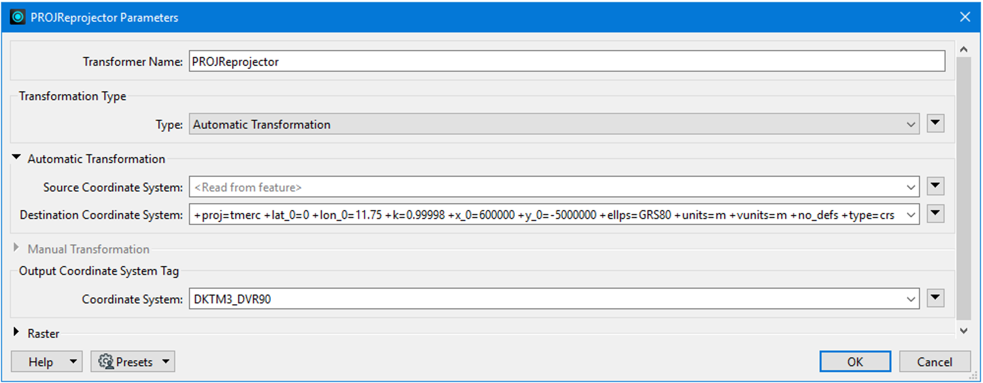
The custom coordinate system definitions created by the website are for the CSMAP reprojection engine, which is used by FME's implicit reprojection, as well as the Reprojector and CsmapReprojector transformers. When using the PROJReprojector, you can use a custom coordinate system by adding the PROJ string to the source or destination coordinate system box:

Screen Shot 2023-11-02 at 9.51.07 AMSet the name of your newly defined coordinate system as the output coordinate system tag. This will ensure that the correct Esri WKT is used when writing to DWG/PRJ.

The Esri WKT used in new definition seems to have carriage returns in it, which will upset most applications when it is placed in the PRJ. When copying the WKT from epsg.io, please use the Copy Text option rather than Copy Formatted. This will remove the carriage returns.


Reply