Can you elaborate a bit? What values are you putting in, what are you expecting to get out of it and what is the actual output?
Yes. Right now I have just created a simple excel file with an x,y header and an x,y value of: 200000, 200000. A point in Jutland. I would expect to get: y: 6 232 728.28 m x: 595 254.05 m
But what i get is: y,x
3988202.0084898225,2825673.214985046
Yes. Right now I have just created a simple excel file with an x,y header and an x,y value of: 200000, 200000. A point in Jutland. I would expect to get: y: 6 232 728.28 m x: 595 254.05 m
But what i get is: y,x
3988202.0084898225,2825673.214985046
Are you sure the input coordinate values (or coordinate system) are correct? If I use a Creator to set a point at 200000,200000 in the DenmarkS34-S system the Data Inspector reports it as in the Mediterranean Sea, off the coast of Lebanon.
It should be correct, because that is how system34 is defined. I mean system34 is defined by this point in jutland with the coordinates 200000m, 200000m
Are you sure the input coordinate values (or coordinate system) are correct? If I use a Creator to set a point at 200000,200000 in the DenmarkS34-S system the Data Inspector reports it as in the Mediterranean Sea, off the coast of Lebanon.
Well, I tried this with all 4 DenmarkS34 systems available and none of them end up in Denmark... Hopefully somebody from Safe's support can chime in (I'm not Danish, so not familiar with Danish coordinate systems)
Are you sure the input coordinate values (or coordinate system) are correct? If I use a Creator to set a point at 200000,200000 in the DenmarkS34-S system the Data Inspector reports it as in the Mediterranean Sea, off the coast of Lebanon.
If you take your expected coordinate y: 6 232 728.28 m x: 595 254.05 m and transform it back to DenmarkS34-J (I've used Jylland rather than Sjælland as your point is there) you get
x:-200000.04766182226
y: 200000.05160261248
I don't know anything about this coordinate system to be able to say what the above proves however...
Are you sure the input coordinate values (or coordinate system) are correct? If I use a Creator to set a point at 200000,200000 in the DenmarkS34-S system the Data Inspector reports it as in the Mediterranean Sea, off the coast of Lebanon.
It is strange why it does not work the other way around then
Are you sure the input coordinate values (or coordinate system) are correct? If I use a Creator to set a point at 200000,200000 in the DenmarkS34-S system the Data Inspector reports it as in the Mediterranean Sea, off the coast of Lebanon.
It's not quite right, the x is minus 200000...
Are you sure the input coordinate values (or coordinate system) are correct? If I use a Creator to set a point at 200000,200000 in the DenmarkS34-S system the Data Inspector reports it as in the Mediterranean Sea, off the coast of Lebanon.
Your x-value is incorrect, if I put in -200000 instead of 200000 it does end up with a point in Denmark. Good catch by @ebygomm
So if this is the case with all your Excel values multiplying that field by -1 should do the trick. You can do that with an AttributeManager or ExpressionEvaluator before the AttributeReprojector.
Are you sure the input coordinate values (or coordinate system) are correct? If I use a Creator to set a point at 200000,200000 in the DenmarkS34-S system the Data Inspector reports it as in the Mediterranean Sea, off the coast of Lebanon.
I wonder if it might be an error in the system, because this definition was used to ensure that there would be no negative coordinates in Denmark. But thanks for the answers, I shall try tomorrow and see if I can solve the problem by making x negative.
Are you sure the input coordinate values (or coordinate system) are correct? If I use a Creator to set a point at 200000,200000 in the DenmarkS34-S system the Data Inspector reports it as in the Mediterranean Sea, off the coast of Lebanon.
Yes, from what I've read, I wouldn't expect negative numbers in Denmark.
I don't think you can just times by -1, because then -300000 would be west of -200000 when presumably 300000 would be east of 200000?
Some more info
"For practical purposes, what is officially the X and Y axis in
this projection is switched to conform with other coordinate
systems, and the X axis is then counted as negative from its
origin East of Denmark, meaning that Agri has coordinates
(-200000, 200000) in my data. "
http://osgeo-org.1560.x6.nabble.com/Custom-projection-wildly-inaccurate-td3848728.html
Thanks for the answer and link. It is still hard for me to completely understand what I should do to make the reprojection.
Is it correct that i should make x=y and y=x and that i should multiply the x coordinates by - 1 before they are switched?
Thanks for the answer and link. It is still hard for me to completely understand what I should do to make the reprojection.
Is it correct that i should make x=y and y=x and that i should multiply the x coordinates by - 1 before they are switched?
Do you have the Danish coordinates for any other known locations? I'd try and verify the logic by taking those coordinates and reprojecting to something you have background mapping for and seeing if they're in the right place
I will send them first thing tomorrow, and explain the location. Thanks for helping.
Do you have the Danish coordinates for any other known locations? I'd try and verify the logic by taking those coordinates and reprojecting to something you have background mapping for and seeing if they're in the right place
Ingen årsag :-)
Do you have the Danish coordinates for any other known locations? I'd try and verify the logic by taking those coordinates and reprojecting to something you have background mapping for and seeing if they're in the right place
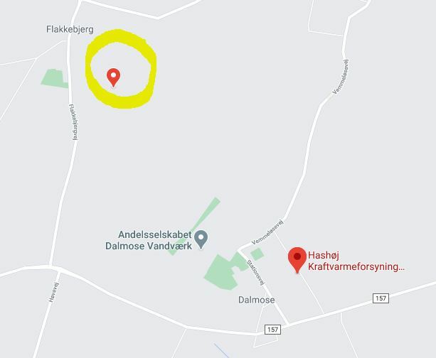
Here is a coordinate: y: 97827,00 x: 144881,00. It is in Western sealand in Denmark near Hashøj fjernvarmeværk.
Do you have the Danish coordinates for any other known locations? I'd try and verify the logic by taking those coordinates and reprojecting to something you have background mapping for and seeing if they're in the right place
If that point is plotted as -144881, 97827 and reprojected that would take you to this location, so that's just multiplying the x by -1
Do you have the Danish coordinates for any other known locations? I'd try and verify the logic by taking those coordinates and reprojecting to something you have background mapping for and seeing if they're in the right place
Perfect, thanks a million!