Question

Problem getting values from PointOnRasterValueExtractor

  • 20 May 2023
  • 3 replies
  • 14 views

Userlevel 1
Badge +8

I am reading several GeoTif and line features from a PostGIS table. To make life easy I added the RasterMosaicker and linked the mosaic to the PointOnRasterValueExtractor.


The line features from the PostGIS table get their vertices densified, and I extract those using the PointVertexReplacer from FME Hub. Since the coordinate systems of the data do not match I use the EsriReprojector for the points to have them as well as the mosaic in EPSG: 4326.

image
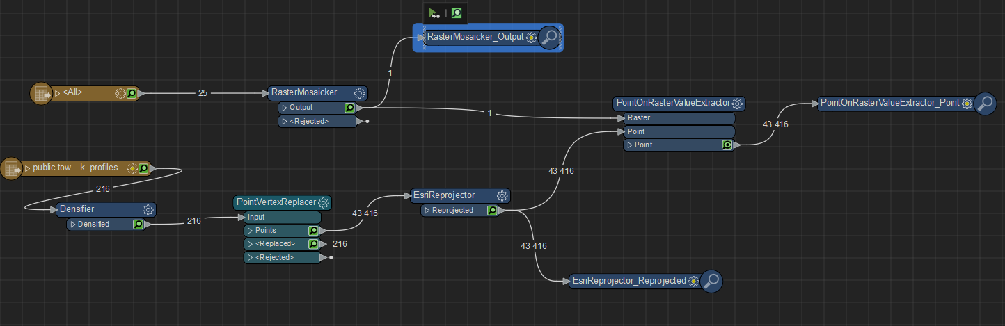
Now, when I run the PointOnRasterValueExtractor the output points do have _band{}.value and _band{}.palette{}.value. I expose _band{0}.value since the mosaic only has one band, but each and every point is missing the value.


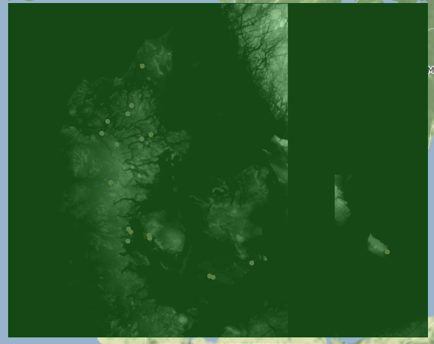
I used the Data Inspector to visualize the points on top of the mosaic, and everything lines up.


Why do I not get any values from the PointOnRasterValueExtractor?


I am using the

Data Interoperability workbench with FME(R) 2022.2.1.0 (20221202 - Build 22776 - WIN64) 

RasterMosaicker in version 7

PointVertexReplacer in version 2

EsriReprojector in version 5

PointOnRasterValueExtractor in version 2


3 replies

Badge +20

If _band{0}.value is missing or empty the points and raster don't overlap or are not in the same coordinate system.

Use coordinate CoordinateSystemExtractor on raster to find out the CRS to reproject to.

Userlevel 1
Badge +8

I am sorry but that seems not the case.

The CoordinateSystemExtractor puts the tif files into 'LL-WGS84', while the line features are in 'EPSG:3035'.

I don't know why, but using the 'Reprojector' in ArcGIS Data Interop. Workbench does not work and I have to use the 'EsriReprojector'.

When reprojecting EPSG:3035 into EPSG:4326 the CoordinateSystemExtractor returns '_LL-WGS84_0'.

Since 'LL-WGS84' to me is not the same as '_LL-WGS84_0' I reproject the tif files as well (from WGS84 to WGS84) and the resulting coordinate system is '_LL-WGS84_0'.


Now both input datasets are in the same coordinate system and visualizingboth in the Data Inspector puts them also perfectly on top of each other. However, the PointOnRasterValueExtractor is still showing all _band{0}.value as missing.


I the Data Inspector does not reproject incoming data on the fly, then the data do line up, and the PointOnRasterValueExtractor should return raster values.


The screenshot from the Data Inspectors shows points on top of raster files, green area indicating bounding box of raster files.

points on top of raster files, green area indicating bounding box of raster files

Userlevel 4
Badge +26

I am sorry but that seems not the case.

The CoordinateSystemExtractor puts the tif files into 'LL-WGS84', while the line features are in 'EPSG:3035'.

I don't know why, but using the 'Reprojector' in ArcGIS Data Interop. Workbench does not work and I have to use the 'EsriReprojector'.

When reprojecting EPSG:3035 into EPSG:4326 the CoordinateSystemExtractor returns '_LL-WGS84_0'.

Since 'LL-WGS84' to me is not the same as '_LL-WGS84_0' I reproject the tif files as well (from WGS84 to WGS84) and the resulting coordinate system is '_LL-WGS84_0'.


Now both input datasets are in the same coordinate system and visualizingboth in the Data Inspector puts them also perfectly on top of each other. However, the PointOnRasterValueExtractor is still showing all _band{0}.value as missing.


I the Data Inspector does not reproject incoming data on the fly, then the data do line up, and the PointOnRasterValueExtractor should return raster values.


The screenshot from the Data Inspectors shows points on top of raster files, green area indicating bounding box of raster files.

points on top of raster files, green area indicating bounding box of raster files

Try projecting to a non-geographic coordinate system. Try re-projecting both datasets to SPHERICAL_MECATOR.

Reply