Question

Create tiles from GeoTIFF using WebMapTiler

  • 21 March 2023
  • 4 replies
  • 18 views

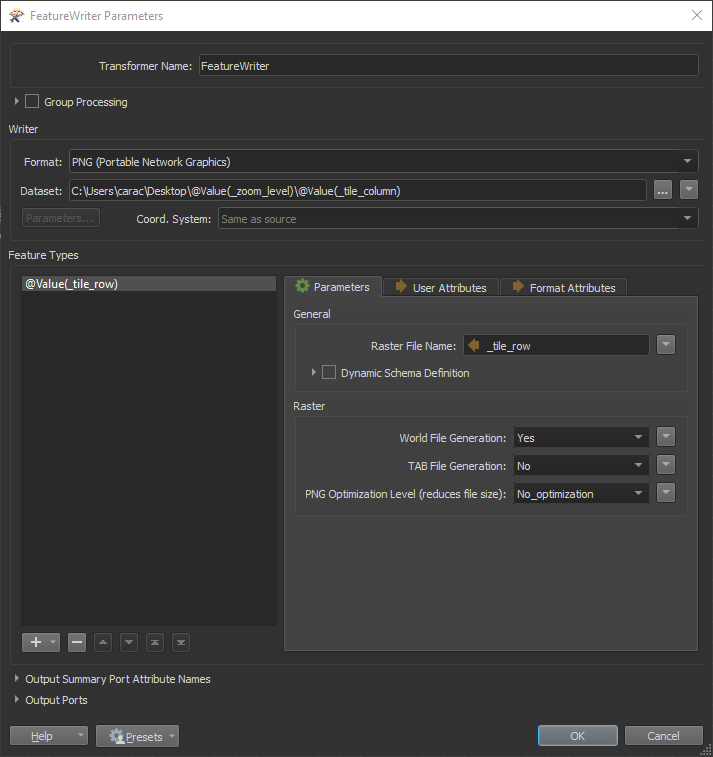
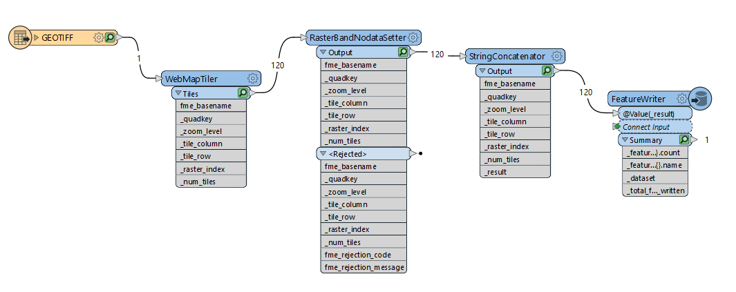
I am trying to create tiles from GeoTIFF and it is unable to create the folder structure needs to be in the format of ../ZoomLevel/X/Y. I tried to reference https://community.safe.com/s/question/0D54Q000080h9x1SAA/writing-tms-folders-and-files, using GoogleMapCompatible tile scheme, but it is not successful. There is no @Value(_x) and @Value(_y) attributes. Please help and thanks.


4 replies

Badge +20

Based on the image you attached:

In FeatureWriter, under Dataset, add @Value(_zoom_level)\\@Value(_tile_column) and under Raster file name select _tile_row attribute.

Fanout_WebMapTiler

Thanks for your help. It works. However, I have other questions after the generation. Firstly, it produces some files in .wld format, is it necessary and how can stop producing .wld files via settings? Secondly, some empty png files are generated. Is it possible to stop producing them from setting? These situations do not happen in other software like MapTiler. wldempty

Badge +20

Thanks for your help. It works. However, I have other questions after the generation. Firstly, it produces some files in .wld format, is it necessary and how can stop producing .wld files via settings? Secondly, some empty png files are generated. Is it possible to stop producing them from setting? These situations do not happen in other software like MapTiler. wldempty

To stop writing World Files just set World File Generation to No.

To get rid of the blank rasters you need first set a No Data Value on the rasters via RasterBandNodataSetter, use RasterExtentsCoercer set to Data MBR Extents and use the output to filter out blank tiles.

Faster (maybe) would be to run RasterExtentsCoercer -> Data Extents on the initial raster (with no data value set) and use the resulting polygon as Filter in SpatialFilter with the tiles as Candidates.

Thank you for you help and the World File Generation issue is resolved. But I am still unable to get rid of the blank raster. I tried to use RasterBandNodataSetter and set to 255 or 0, the blank raster data cannot be filtered. If I add RasterExtentsCoercer and set MBR Extents, it cannot transform and produce error. No matter I set the transformers before or after WebMapTiler.


image 

In addition, may I know how to improve the performance of WebMapTiler. It seems slow comparing to other software like MapTiler. Can WebMapTiler support parallel processing? I also upload the FME file for your references.


Reply