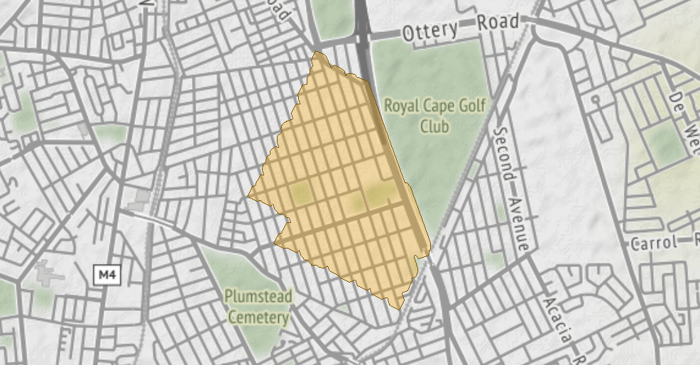
I get a response from an API GET request in JSON and it contains the coordinates for a polygon.
{"authenticationResultCode":"ValidCredentials","brandLogoUri":"http:\/\/dev.virtualearth.net\/Branding\/logo_powered_by.png","copyright":"Copyright © 2022 Microsoft and its suppliers. All rights reserved. This API cannot be accessed and the content and any results may not be used, reproduced or transmitted in any manner without express written permission from Microsoft Corporation.","resourceSets":[{"estimatedTotal":1,"resources":[{"__type":"IsochroneResponse:http:\/\/schemas.microsoft.com\/search\/local\/ws\/rest\/v1","dataSourcesUsed":[5],"origin":{"latitude":-34.021682824034,"longitude":18.4837339189645},"polygons":[{"coordinates":[[[-34.0224675816069,18.47607560705454],[-34.021900339603782,18.476424942466956],[-34.021834632851942,18.47667223294113],[-34.021763236949283,18.4766453367028],[-34.02119900085917,18.477001621671914],[-34.021216553524575,18.477231713278478],[-34.020956999043712,18.477130968901353],[-34.020613182625453,18.477165228610041],[-34.020460500759683,18.47738177759841],[-34.020197274110672,18.477411260748216],[-34.020028031581866,18.477656322794978],[-34.019802103094847,18.477680432421995],[-34.019580702909352,18.477998187715652],[-34.019601606286329,18.478280685384213],[-34.019283631607479,18.478160238254329],[-34.018940023376381,18.478197389117021],[-34.018722648397407,18.47851010213002],[-34.018528104661172,18.478413958150266],[-34.01820967392387,18.478573394162236],[-34.01813108338073,18.478802746305377],[-34.018099714056845,18.47879072486916],[-34.018099677466253,18.478790863849508],[-34.018099330523377,18.47879218163267],[-34.017970372857704,18.479281993021754],[-34.017639074467681,18.479154360387163],[-34.017072945763594,18.479506272203515],[-34.0170920692713,18.47977598441711],[-34.016793995381306,18.479663696106591],[-34.016669161449684,18.479677428124653],[-34.016573522458877,18.479580334717131],[-34.016006999468921,18.479931326036215],[-34.015912278815946,18.480290824496546],[-34.015834692088688,18.480261149155183],[-34.0154909990064,18.480297151390484],[-34.01537047750454,18.480469549052184],[-34.0150520008598,18.480483053639635],[-34.014891245234551,18.480690232564069],[-34.014580191498766,18.480550872376835],[-34.014006360267977,18.480854633150074],[-34.014240674132253,18.481553169575861],[-34.014917772678047,18.481918272714221],[-34.014944781118892,18.481918616811349],[-34.014966418962409,18.481940321058904],[-34.014981010804057,18.481945853677598],[-34.014821986407462,18.482189951276819],[-34.015126562853268,18.482855585954933],[-34.015437923088477,18.482968524449607],[-34.015308968541127,18.483155129847685],[-34.015340905001729,18.483567656598783],[-34.015581183949571,18.483807116203618],[-34.015542747650215,18.483857201467881],[-34.01580779728463,18.48455141641228],[-34.01689449527273,18.485044021956572],[-34.0169231541725,18.485042336320952],[-34.021184554353411,18.486918063330727],[-34.021192929046379,18.486926897273868],[-34.021669844780483,18.48713483418943],[-34.021681195787274,18.487267644578697],[-34.021929685696385,18.487528684644019],[-34.025207993561445,18.488951158754297],[-34.025548806145046,18.488933010843251],[-34.025624141281114,18.488835949374547],[-34.025894926614114,18.488810963573119],[-34.0260995406635,18.488093399742848],[-34.025882985623319,18.487857532099572],[-34.025971214585958,18.48777024410462],[-34.026685957869965,18.48804046705963],[-34.0266868438813,18.488040803352717],[-34.026687323991638,18.488040983554118],[-34.026697057307004,18.488003502684709],[-34.026822573541146,18.488065540915475],[-34.027141005087628,18.487906092431633],[-34.027246695005537,18.487597627270418],[-34.027363296672711,18.487657098280618],[-34.027967051385232,18.487324502040963],[-34.028073171360539,18.486926280959285],[-34.028526131863913,18.487098807818242],[-34.029091286639357,18.486744600394335],[-34.028796370887747,18.48606580630863],[-34.028346243706125,18.485894364071445],[-34.028457452663879,18.485471149615019],[-34.028127541736993,18.484778819328689],[-34.027794171201627,18.484687275441306],[-34.027947856947556,18.484466742407083],[-34.027652802915249,18.483788044087579],[-34.027338902897689,18.483668591029684],[-34.027460271376796,18.483190892391391],[-34.0271634230525,18.482514611812586],[-34.027065202404287,18.482525286226121],[-34.027087320528523,18.48249364581288],[-34.02679312704953,18.481814415637444],[-34.026502839766117,18.48170336061084],[-34.026633173274639,18.481516033468804],[-34.026602402199465,18.481103324353395],[-34.026475166370844,18.480975629426688],[-34.026479007465724,18.480961216729682],[-34.026451353816888,18.480548191188376],[-34.026194129638355,18.480285239303104],[-34.026179936050973,18.480099599983987],[-34.025914698298529,18.47983462787905],[-34.025612204207377,18.4797207516613],[-34.025750122150541,18.479530791543453],[-34.025466556825819,18.478845082473086],[-34.025442160079578,18.478835137255512],[-34.025502294177549,18.478605759011014],[-34.025209211723123,18.477925848905244],[-34.024643105574825,18.478277842637151],[-34.024582356733106,18.478509565998916],[-34.024530160100589,18.478491292639347],[-34.0239720216991,18.478861182861376],[-34.023995024268551,18.479107858623088],[-34.023711110040232,18.478999560985887],[-34.02369685843221,18.47878958296112],[-34.023511032424771,18.478600044901057],[-34.023484039584922,18.478256056805524],[-34.023218274307013,18.477991856465636],[-34.022925210673833,18.4778824656244],[-34.023056825350132,18.477689710614595],[-34.022756105751128,18.477014647618418],[-34.022695843317315,18.476992520407869],[-34.022758460142889,18.476756859198957],[-34.0224675816069,18.47607560705454]]]}]}]}],"statusCode":200,"statusDescription":"OK","traceId":"5828fe21e6f141b2a49cc0b8d0ad6760|DU0000276C|0.0.0.0|DU000005EB,DU00001F72"}Is there a way for me to extract the polygon definition from the JSON and (a) write it to a shapefile and (b) use it as a spatial filter?
Thanks,
tC/.