Solved

How to solve "Invalid longitude value given for projection origin"?


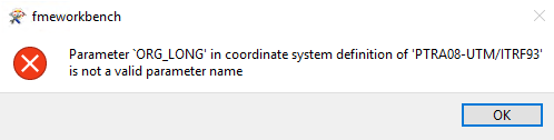
I'm using a coordinate system that is not in FME’s Coordinate System Gallery. I added a custom coordinate system by creating a new .fme file and using the online tool. When I use it in my FME model it give me the message: "Invalid longitude value given for projection origin".

My .fme file has this information:

COORDINATE_SYSTEM_DEF PTRA08-UTM/ITRF93 \\

  DESC_NM "PTRA08 / UTM zone 26N EPSG:5015" \\

  GROUP EUROPE \\

EL_NAME GRS1980 \\

  ORG_LAT 0 \\

  PARM1 -27.0 \\

  PROJ UTM \\

  QUAD 1 \\

  SCL_RED 0.9996000000 \\

  SOURCE "https://www.dgterritorio.gov.pt/geodesia/sistemas-referencia/regioes-autonomas/PTRA08-UTM-ITRF93" \\

  UNIT METER \\

  X_OFF 500000 \\

  Y_OFF 0


I think the error is in PARM1, but I think it's ok... -27

icon

Best answer by geomancer 17 August 2022, 16:56

View original

7 replies

Userlevel 4
Badge +26

Have you tried renaming PARM1 to ​ORG_LONG?

Have you tried renaming PARM1 to ​ORG_LONG?

image.png

Userlevel 4
Badge +36

Probably should be ORG_LNG.

Probably should be ORG_LNG.

I tried that and the parameter was accepted but the error persisted

Userlevel 4
Badge +36

Studying the documentation on Local Coordinate Systems, it appears that for proj UTM you must provide PARM1 ("UTM zone number. Note that this must be an integer value between 1 and 60, even though it is carried in a variable of the double type.") and PARM2 ("The hemisphere of the zone. Use a positive value for northern hemisphere and a negative value for the southern hemisphere.")

Also the documentation states that the sting SOURCE has a maximum length of 63.

There may be other issues.

Thank you! I think that this error is solved..

Now it's a different error: "A fatal error has occurred. Check the logfile above for details

is not a supported projection."

Userlevel 4
Badge +36

Studying the documentation on Local Coordinate Systems, it appears that for proj UTM you must provide PARM1 ("UTM zone number. Note that this must be an integer value between 1 and 60, even though it is carried in a variable of the double type.") and PARM2 ("The hemisphere of the zone. Use a positive value for northern hemisphere and a negative value for the southern hemisphere.")

Also the documentation states that the sting SOURCE has a maximum length of 63.

There may be other issues.

I see you have modified the text in your original post. Assuming this is your current setup, you are still missing PARM2.

The settings below work for me (at least I can assign the coordinate system to a test object with the CoordinateSystemSetter), but it may not be correct or complete for your purpose:

COORDINATE_SYSTEM_DEF PTRA08-UTM/ITRF93 \
DESC_NM "PTRA08 / UTM zone 26N EPSG:5015" \
GROUP EUROPE \
EL_NAME GRS1980 \
PROJ UTM \
PARM1 -27 \
PARM2 1 \
SCL_RED 0.9996000000 \
SOURCE "https://www.dgterritorio.gov.pt/geodesia/sistemas-referencia/regioes-autonomas/PTRA08-UTM-ITRF93" \
UNIT METER \
X_OFF 500000


Reply