Question

Using a WMS in a HTML Report Generator


Badge +9

I have a WMS feed that I want to include in an HTML report but don't understand how to to get the HTMLReportGenerator to use it.


I have a polygon layer that I group by, buffer it slightly and then user the feature reader on the WMS layer.


image 

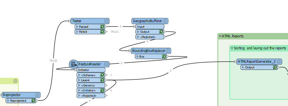
If I user the Map option the base map is present but no WMS.


Any suggestions?


4 replies

Userlevel 6
Badge +33

Not sure what you need exactly and different things are possible.

Do you want a report with an interactive map which has a wms service as base layer? Or do you need a report with an image of the point of interest with the wms as background?

Badge +9

Not sure what you need exactly and different things are possible.

Do you want a report with an interactive map which has a wms service as base layer? Or do you need a report with an image of the point of interest with the wms as background?

Thanks @nielsgerrits​ . I have created a report with the HTML Report Generator and need just the WMS image to be included that shows the coverage area of the report.

Userlevel 6
Badge +33

Thanks @nielsgerrits​ . I have created a report with the HTML Report Generator and need just the WMS image to be included that shows the coverage area of the report.

Is the FeatureReader the WMS reader? Then write the result of the FeatureReader to a temp PNG file and embed the file in the report as image. Attached workspace demonstrating this.

Badge +9

Thanks @nielsgerrits​ . I have created a report with the HTML Report Generator and need just the WMS image to be included that shows the coverage area of the report.

Thanks @nielsgerrits​ , yes the FeatureReader is the WMS Reader. I was thinking a similar solution but there is potentially 1000's of images so wanted to avoid creating a temp image but that does seem to be the simplest option. Cheers Dean

Reply