Question

Arc geometry differs between formats!

  • 14 January 2022
  • 5 replies
  • 29 views

Badge

Hi there,


I came up with a problem within one of my data translations within FME concerning arc objects. The routine is about converting a geopackage file into a filegeodatabase. The included objects and their geometry are not manipulated inbetween.


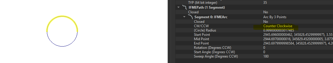
Arc objects within the geopackage-file are defined as geometry type "Arc by three points". The arc objects within the geopackage-file have all been constructed by 3 points (end, middle and startpoint). This logically means, that the arc line is intersecting with those three points.


image 

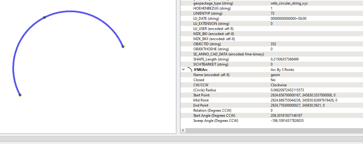
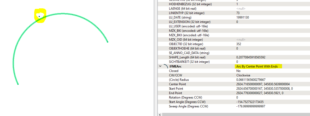
After converting this geometry to a file geodatabase, the arc geometry has changed and is within a tolerance of the arc middle point. When checking the geometry info of the same arc within the file geodatabase, it states that tie IFMEArc is "Arc By Center Point With Ends) - but, most important, the geometry has changed!


image 


Why does FME not convert the arc geometry in the exact way into the file geodatabase? Is there any way to change the IFME Type within the file geodatabase specification to Arc by 3 points? Or is there any other way to define that new objects, who are imported into a file geodatabase keep their exact geometry??


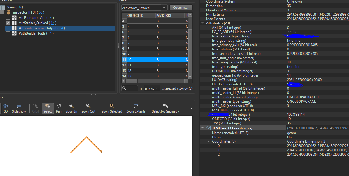
I also tried a workaround by manipulating the geopackage arc before converting:


-> ArcStroker: Arc to 2 Line segments ( start to middle point, middle to end point)

image-> 
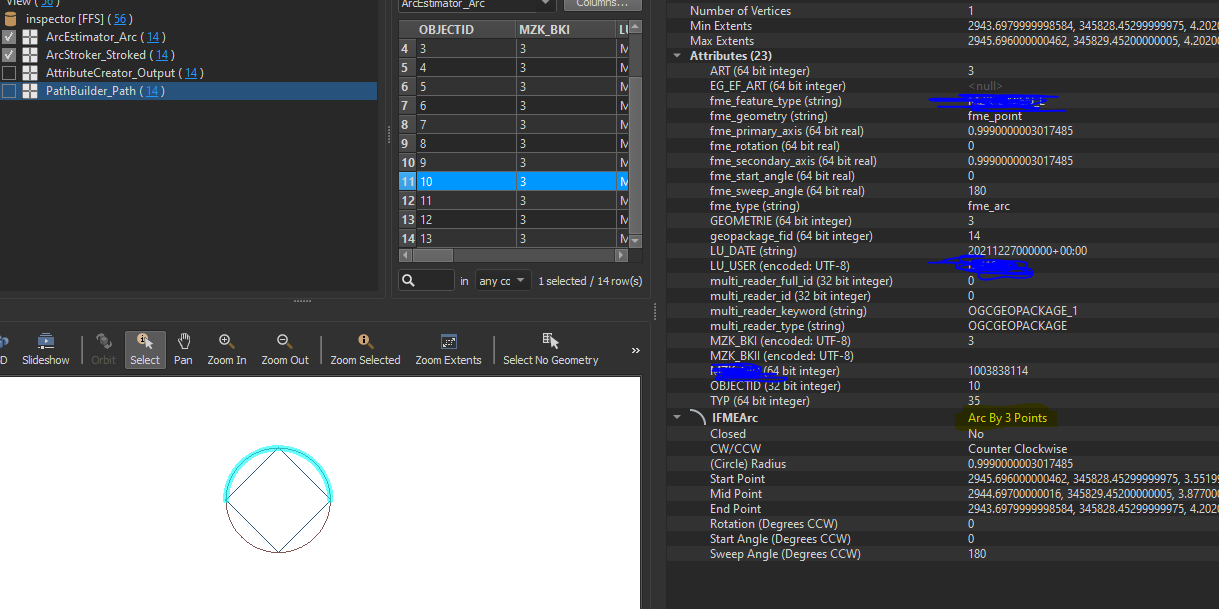
ArcEstimater: Polylines to Arc

image-> PathBuilder: Arc to Line object for the database import

When inspecting the result of the path builder, the geometry is IFME Arc by 3 points.

image 


Why does the translation into a fgdb object change the geometry of an arc object? Is there any way to translate the exact same geometry of an arc into a file geodatabase?


5 replies

Userlevel 1
Badge +21

Isn't this just the (very small) geometry shift you get when writing to various ArcGIS formats due to resolution and tolerance settings?

Userlevel 4

FME supports three types of arc definitions:

  • Arc by center point, radius and sweep
  • Arc by bulge
  • Arc by three points

More information here: http://docs.safe.com/fme/2021.2/html/FME_Desktop_Documentation/FME_Workbench/!FME_Geometry/Arcs.htm

Generally speaking, not very many formats support all these arc types, meaning that FME may have to convert between arc definitions when reading and writing arcs between formats, depending on how they expect the arcs to be defined. This is, in my experience, not something that is mentioned in the log, but it does happen.

Badge

Isn't this just the (very small) geometry shift you get when writing to various ArcGIS formats due to resolution and tolerance settings?

Thanks for the input @ebygoom. Do you know if there is any way to change the resulition and tolerance settings to achieve no change within the geometry when converting?

Badge

FME supports three types of arc definitions:

  • Arc by center point, radius and sweep
  • Arc by bulge
  • Arc by three points

More information here: http://docs.safe.com/fme/2021.2/html/FME_Desktop_Documentation/FME_Workbench/!FME_Geometry/Arcs.htm

Generally speaking, not very many formats support all these arc types, meaning that FME may have to convert between arc definitions when reading and writing arcs between formats, depending on how they expect the arcs to be defined. This is, in my experience, not something that is mentioned in the log, but it does happen.

thank you david! i also tried to convert new arcs from a file geodatabase into another file geodatabase, altough the fGDB type is always "Arc by center point, radius and sweep", the geometry of the arc slightly changes in the new file geodatabase as well. Do you know if there is any way of transferring a new arc-object into a file geodatabase without and changes within the geometry?

Userlevel 4

thank you david! i also tried to convert new arcs from a file geodatabase into another file geodatabase, altough the fGDB type is always "Arc by center point, radius and sweep", the geometry of the arc slightly changes in the new file geodatabase as well. Do you know if there is any way of transferring a new arc-object into a file geodatabase without and changes within the geometry?

In my experience there will "always" be minuscule differences when reading to and from Esri Geodatabases (file or enterprise) and other formats, as the contents of the Esri feature classes is subjected to a snapping grid that is a part of the feature class definition. This is why it is so important consider your use case when defining the Esri feature class tolerance and resolution. The goal is to make sure that the differences are negligible, i.e. having a snapping grid that is much smaller than the real data resolution.

Reply