Solved

NetCDF + rotated coordinate system (rlat, rlon)


Badge +21

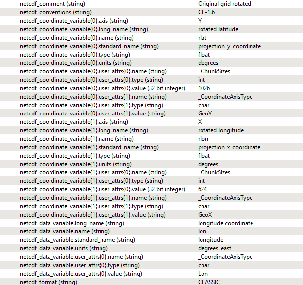
Have anyone got rotated coordinate systems work with FME? See metadata below. If I just use the RasterGeoreferencer it does not rotate, and I do not have an angle for the Rotator...

Is there no way to define the coordinate system as a "rotated" one?
icon

Best answer by david_r 9 May 2017, 10:53

View original

11 replies

Userlevel 4

Let me guess, COSMO-data?

Funny you should ask, I've been wrangling with exactly this for a while now. The bad news is that this particular coordinate system isn't supported by FME, but there is a way to do it yourself, although it's a bit convoluted. I'll post some more info later today when I have the time.

Badge +21

Thats great! There is a solution over at: https://wiki.met.no/fimex/start - however it demands linux - so its not an option for the moment.

Userlevel 4

Thats great! There is a solution over at: https://wiki.met.no/fimex/start - however it demands linux - so its not an option for the moment.

If you have the motivation, it might perhaps be possible to compile it for Windows?
Userlevel 4

Here's a workspace that Dean Hintz from Safe developed to reproject a raster from rot.pol to lon/lat coordinates, hopefully it can give you some pointers.

rotatedspherical-3drotator-netcdf-v3.fmw

Just be aware that the rotated (south) pole is hardcoded at (10,-40) which might not be the exact parameters you want, so look out for those constants.

Also it's kind of a proof of concept, so I wouldn't trust the results too much without doing extensive testing on your side.

Userlevel 4

Alternatively, here's a small Python function I wrote that reprojects both ways between rot.pol and lon/lat with a custom pole position. It should be fairly easy to incorporate into a PythonCaller, look at the bottom 20 lines for some usage examples. Let me know if you have questions.

rotated-grid-transform.py

No guarantees given as it hasn't been fully tested yet...

Badge +21

Thank you David! I had a quick look at both - and it seems I need to get some hours of to see if I can fix it.I`ll let you know ASAP.

Userlevel 4

Thank you David! I had a quick look at both - and it seems I need to get some hours of to see if I can fix it.I`ll let you know ASAP.

Yeah, it's surprisingly hard to work with these rotated pole projections. Let's hope Safe (paging @daleatsafe) can include official support in a future release, seems like this is an issue that will crop up fairly frequently.


Badge +21
Yeah, it's surprisingly hard to work with these rotated pole projections. Let's hope Safe (paging @daleatsafe) can include official support in a future release, seems like this is an issue that will crop up fairly frequently.


Off topic: I see you also can not use the @daleatsafe - mention - tag. I also have this annoying problem, so I cant notify anyone. I have tried 3 different computers, multiple web browsers and mobile. So it is a config-setting that Safe Software needs to tweek on the Answerhub-system. Same as mentioned here https://knowledge.safe.com/questions/40222/why.html


Userlevel 4
Off topic: I see you also can not use the @daleatsafe - mention - tag. I also have this annoying problem, so I cant notify anyone. I have tried 3 different computers, multiple web browsers and mobile. So it is a config-setting that Safe Software needs to tweek on the Answerhub-system. Same as mentioned here https://knowledge.safe.com/questions/40222/why.html


Yup, was never able to get it to work...
Userlevel 4
Badge +13

Thank you David! I had a quick look at both - and it seems I need to get some hours of to see if I can fix it.I`ll let you know ASAP.

I've escalated both issues at Safe -- thanks for pointing them out (the coordinate system + the paging...)


Userlevel 4
I've escalated both issues at Safe -- thanks for pointing them out (the coordinate system + the paging...)


That's fantastic news for everybody working on meteorological / climatological data (at least in Europe), thanks!

Reply