
I want to get this. I upload shp, xls and fmw. Can you give me some idea. Thanks a lot.

I want to get this. I upload shp, xls and fmw. Can you give me some idea. Thanks a lot.

 +17
+17
The uploaded files are broken for some reason. Please upload them again.
I'm not able to upload until Monday. Then I will.The uploaded files are broken for some reason. Please upload them again.
example.xlsxpie_maker.fmw roads_part.zip
+17
Hi @maloks, I think you need to modify the workspace at these two points.
First, you have to create point geometry based on LAT and LON with a VertexCreator before reprojection, since features read from Excel dataset don't have any geometry.
Second, you cannot use coordinate system name "HTRS96" in the Reprojector setting, since FME doesn't support it. You need to select an appropriate coordinate system from the FME Coordinate System Gallery.
Making pie shapes is ok, I made custom coordinate system HTRS96. My problem is in the next step where I have to get id from pie in the attribute table of roads like on the picture above.
+17
Hi @maloks, I think you need to modify the workspace at these two points.
First, you have to create point geometry based on LAT and LON with a VertexCreator before reprojection, since features read from Excel dataset don't have any geometry.
Second, you cannot use coordinate system name "HTRS96" in the Reprojector setting, since FME doesn't support it. You need to select an appropriate coordinate system from the FME Coordinate System Gallery.
I cannot see the picture. Could you please post it again?
I cannot see the picture. Could you please post it again?
So, here is the picture.
+17
You can use the AreaOnAreaOverlayer to overlay the pie-shape areas and populate Cell IDs of overlapped areas into a list attribute. Then, concatenate the list elements (i.e. Cell IDs) with the ListConcatenator delimited by your preferred separator and transfer it to clipped lines with the Clipper.
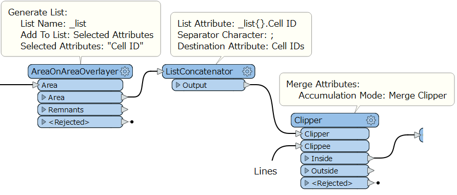
Hope this helps.
You can use the AreaOnAreaOverlayer to overlay the pie-shape areas and populate Cell IDs of overlapped areas into a list attribute. Then, concatenate the list elements (i.e. Cell IDs) with the ListConcatenator delimited by your preferred separator and transfer it to clipped lines with the Clipper.
Hope this helps.
Thanks a lot.
Enter your username or e-mail address. We'll send you an e-mail with instructions to reset your password.
