
I'm using the ESRIReprojector transformer. When converting between NAD83 and NAD27, I get one option for Geographic Transformer. In ArcGIS, I get several options for Geographic Transformer. Is there any way to get the same multiple options in FME without recreating them? Thanks.


Userlevel 2
 +17
+17
- Safer
- 1580 replies
-
7 November 2019

Hi @wmwatson91,
The EsriReprojector will only list transformations applicable to the coordinate systems you have chosen. For example: UTM zone 1 has only one transformation available (Alaska), while UTM zone 10 has two (NTv2 and NADCON).
What coordinate systems are you converting between, and which transformations does ArcGIS show as available for them?
Thanks, @daveatsafe, I have about 24 different combination options. The one I want includes NAD_1927_To_WGS_1984_79_CONUS. Here's an image of the full list of choices. in FME, the only option I have is NAD27_TO_NAD83_NADCON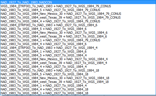
Userlevel 2
+17
- Safer
- 1580 replies
-
7 November 2019
Hi @wmwatson91,
ArcGIS appears to show all the available multi-step transformations as well.
We do have an open enhancement request to add multi-step transformations to the EsriReprojector (FMEENGINE-9684). I have added your name to the request, and will notify you as soon as it is available in beta.

 +10
+10
- Contributor
- 100 replies
-
17 April 2024

NAD 1927 To NAD 1983 NADCON + WGS 1984 (ITRF00) To NAD 1983
Are these transformations available in the other reprojectors (i.e. csmap, fme) or just the esrireprojector?
please add me. is this multi step already implemented?
Thanks
Userlevel 2
+17
- Safer
- 1580 replies
-
17 April 2024
FME 2023 introduced the ability to use multi-step transformations in the EsriReprojector.
All reprojectors have their own libraries of coordinate systems and transformations. That combination of transformations is specific to the EsriReprojector. The equivalent for the CsmapReprojector would be NAD27_to_WGS84 (Mulitstep).
The PROJReprojector automatically determines the optimum transformation required. In this case, it uses the following transformation:
proj=pipeline
step inv proj=utm zone=10 ellps=clrk66
step proj=hgridshift grids=us_noaa_conus.tif
step proj=hgridshift grids=us_noaa_WO.tif
step proj=utm zone=10 ellps=WGS84
Reply
Enter your username or e-mail address. We'll send you an e-mail with instructions to reset your password.