X, Y, Z coordinates of point cloud.


 +9
+9
I would suggest using the vertex creator to create the points and the use the Excel Writer
https://docs.safe.com/fme/html/FME_Desktop_Documentation/FME_ReadersWriters/xlsx/XLSX_writer.htm


Userlevel 6
 +33
+33
- Celebrity
- 2347 replies
-
1 November 2019

Not tested but I think creating a Point Cloud XYZ file is much quicker. (pointcloudformat to pointcloudformat) A Point Cloud XYZ is like a CSV which should work ok in Excel.
But more important is the question, why do you need pointcloud coordinates in Excel? I think the limit of Excel is still 1,048,576 rows. Most pointclouds have multiple times more points. Converting a pointcloud to Excel just does not feel right?
Update
Added screenshot and FME 2019 templatefile.
e57_xyz.fmwt
Thanks for the reply.
You are correct excel won't be able to handle point cloud data.
Can you please tell me the process to extract the coordinates in XYZ file.
I want to use these coordinates for 3D face recognition algorithm.
Userlevel 6
+33
- Celebrity
- 2347 replies
-
4 November 2019
Thanks for the reply.
You are correct excel won't be able to handle point cloud data.
Can you please tell me the process to extract the coordinates in XYZ file.
I want to use these coordinates for 3D face recognition algorithm.
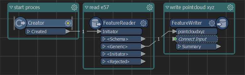
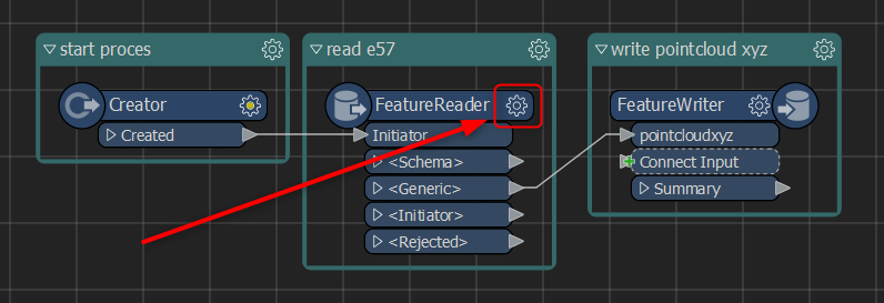
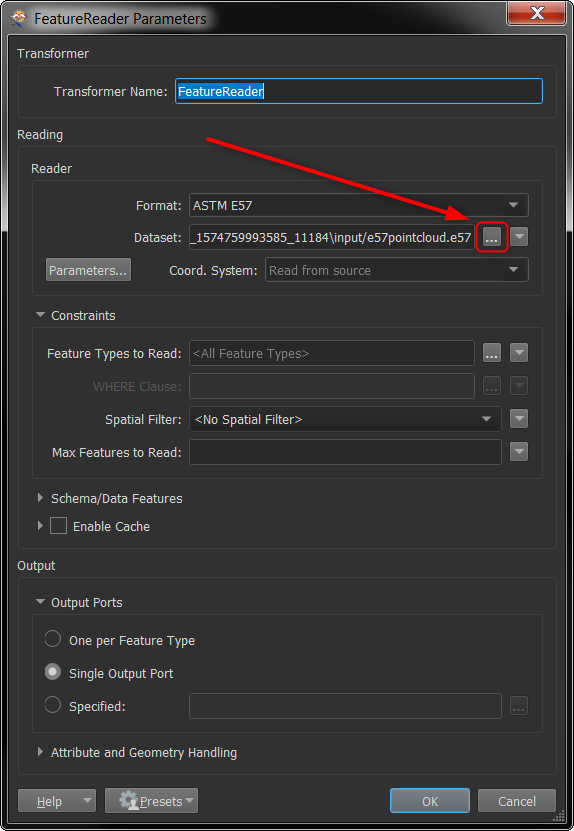
Creator to initiate the translation. FeatureReader, point to file, it will select the format automatically. Connect the outputport to the inputport of a FeatureWriter. Select PointCloud XYZ format. Select file location. Click run to start translation.
Not tested but I think creating a Point Cloud XYZ file is much quicker. (pointcloudformat to pointcloudformat) A Point Cloud XYZ is like a CSV which should work ok in Excel.
But more important is the question, why do you need pointcloud coordinates in Excel? I think the limit of Excel is still 1,048,576 rows. Most pointclouds have multiple times more points. Converting a pointcloud to Excel just does not feel right?
Update
Added screenshot and FME 2019 templatefile.
e57_xyz.fmwt
Hi, I tried to implement this but all I m getting is coordinates of a Cubical structure on giving any input, Can you check the screenshot to figure out where I might be going wrong.

Userlevel 1
 +11
+11
- Safer
- 622 replies
-
26 November 2019

Hi @mryashtomar,
I received your case and I'm really sorry for my late response. I'm glad to see that you've brought your question to the Forums and got some help in the meantime!
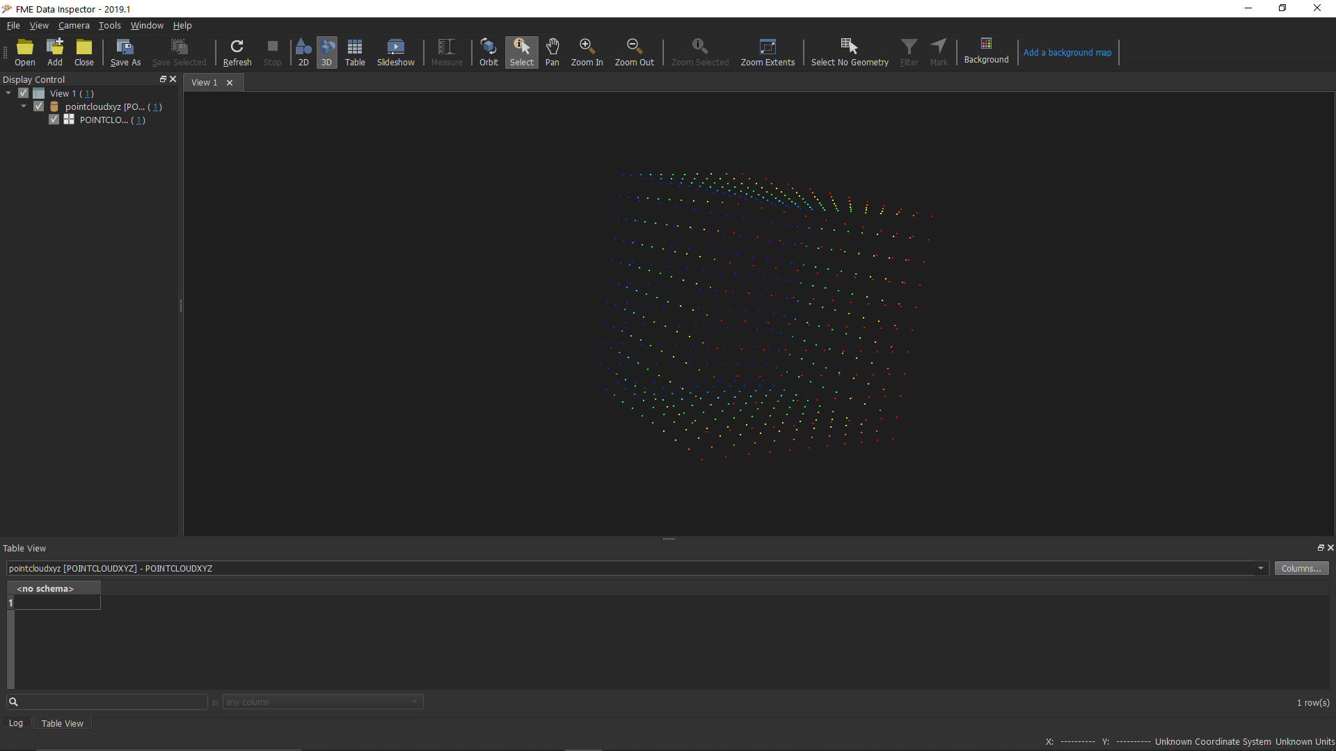
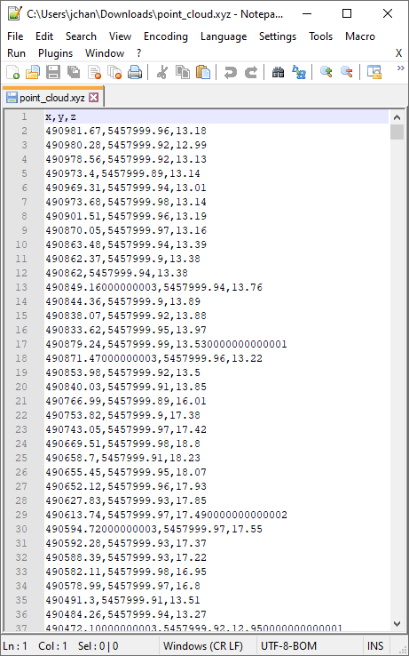
Have you already tried adding just an E57 reader and connecting it to a PointCloudXYZ writer? This seems to work successfully for me on sample data and then I can see all the coordinates of my point cloud when I open the .xyz file in Notepad++. If you have multiple features read in from your .e57 file, you may want to use a PointCloudCombiner to merge it into one point cloud so you get only a single .xyz file output.
You can even specify the extension to .CSV instead of .XYZ if you wish, and you might want to change the delimiter character from space to a comma if that matters to you.
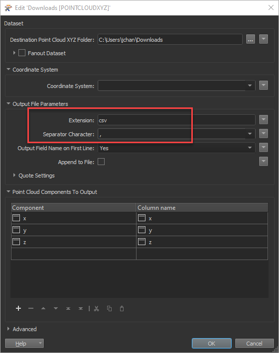
Some things to keep in mind on this though are to be sure to check the parameters when adding the writer as you may need to remap some of the components (look for anything red that needs to be corrected in the table). I found that to view the output, it was easier doing it in the Data Inspector and opening the file anew, than the Visual Preview, and you can right click the output file as well to view it in a notepad or text program. This is what my output looked like:
Let me know if that helps and I can close your case for you, or else feel free to reply to the case emails and send a sample of your dataset and I can take a look at it there as well.
Thanks!
-Jovita
Userlevel 6
+33
- Celebrity
- 2347 replies
-
26 November 2019
Hi, I tried to implement this but all I m getting is coordinates of a Cubical structure on giving any input, Can you check the screenshot to figure out where I might be going wrong.
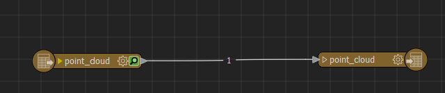
@mryashtomar you need to open the featurereader and select another file. The cube is the sample data I provided with the template, to demonstrate it is working.
The reason it fails is because you replaced the Creator by a Classic Reader, reading the file. You can do this, but the Classic Reader needs to replace the Creator and the FeatureReader.
Reply
Enter your username or e-mail address. We'll send you an e-mail with instructions to reset your password.