Solved

Irish Grid to British National Grid like Mapinfo


Badge

Hi,

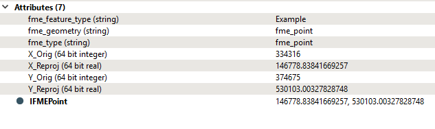
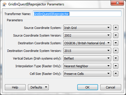
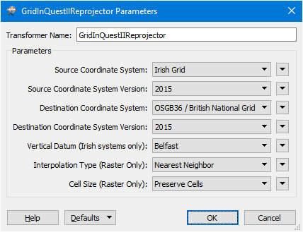
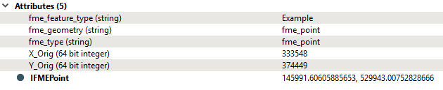
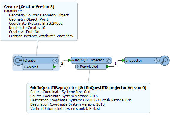
we used to have a process where we would open up some Irish national grid in MapInfo create points and then re-save the file as British National Grid. I'm trying to replicate this in FME, however when using either the reprojector or setting within the read/write i'm seeing a few metres difference. are you able to advise?

icon

Best answer by mark2atsafe 28 June 2017, 15:38

View original

23 replies

Userlevel 1
Badge +21

Which coordinate system are you going from/to in EPSG terms?

Badge

Which coordinate system are you going from/to in EPSG terms?

I'm going from EPSG:29902 to EPSG:27700

Badge +2

I'm going from EPSG:29902 to EPSG:27700

@alicedevereux can you give example values in IG that you are converting to BNG


Badge

Hi Mark_1spatial

An example IG value is: 334316|374675

when converted to BNG using mapinfo: 146779|530100

when converted to BNG using FME: 146778|530103

as you can see only slightly different....

[moderator note: edited with info from other answer]

Badge +2

@alicedevereux I'm seeing slightly different to you:

And when I convert that BNG coordinate to Lat Long and check in Google Maps it is the same place as the IG value in Belfast (SE corner of Royal Mail building)

Userlevel 4
Badge +25

Just looking into this now. Taking quite a while!

Anyway, how are you carrying out the reprojection? Have you tried the GridInQuestReprojector? I don't know much about it, but it says that the purpose is to convert "the national coordinate systems of Great Britain, Northern Ireland and the Republic of Ireland" so that would be something to look at for sure. The problem there is that I can't get it to work! At all. I will continue trying.

The other issue is that there must be a datum transformation of some sort going on, and I just can't find which it is. The CsmapReprojector lets me choose, and I can get multiple results from different transformations, I just can't find the ones that your MapInfo version is using!

So, will check some more and get back to you shortly.

Userlevel 1
Badge +21

Just looking into this now. Taking quite a while!

Anyway, how are you carrying out the reprojection? Have you tried the GridInQuestReprojector? I don't know much about it, but it says that the purpose is to convert "the national coordinate systems of Great Britain, Northern Ireland and the Republic of Ireland" so that would be something to look at for sure. The problem there is that I can't get it to work! At all. I will continue trying.

The other issue is that there must be a datum transformation of some sort going on, and I just can't find which it is. The CsmapReprojector lets me choose, and I can get multiple results from different transformations, I just can't find the ones that your MapInfo version is using!

So, will check some more and get back to you shortly.

And just to add further to the confusion, if you do the re-projection within Oracle you get a figure that matches neither FME or mapinfo :-D


Userlevel 4
Badge +25

Just looking into this now. Taking quite a while!

Anyway, how are you carrying out the reprojection? Have you tried the GridInQuestReprojector? I don't know much about it, but it says that the purpose is to convert "the national coordinate systems of Great Britain, Northern Ireland and the Republic of Ireland" so that would be something to look at for sure. The problem there is that I can't get it to work! At all. I will continue trying.

The other issue is that there must be a datum transformation of some sort going on, and I just can't find which it is. The CsmapReprojector lets me choose, and I can get multiple results from different transformations, I just can't find the ones that your MapInfo version is using!

So, will check some more and get back to you shortly.

Right. It totally depends on what datum and related transformations you are using. I don't know what the default FME ones are (for using a Reprojector or Coordinate System settings) but I see many that you can pick from.


However... I think that's all redundant. What you should be using is the GridInquest transformer. That is the official Irish tool for converting coordinate systems. I finally got it to work (the settings are tricky and depend on where your data is). This is what I used:


Obviously you might want to tweak this a little (maybe your source is 2015, not 2002) but I think this provides the definitive answer: 146776.21347994561,530102.7005781912


If you want your data to be the same as MapInfo provides, then I think we'll need to know what transformations they are actually doing.


You could investigate by converting Irish Grid to ETRS89 Geodetic using both MapInfo and the GridInquest transformer, and see what the difference is. If there's no difference, then it must be in the conversion to OSGB that the difference occurs.


Hope this helps!


Userlevel 4
Badge +25
nb: to help clean up this thread I edited/deleted a couple of comments and posts. Hopefully it's simpler to read now.


Badge +2
And just to add further to the confusion, if you do the re-projection within Oracle you get a figure that matches neither FME or mapinfo :-D


Yep I found that but got dragged into a FME Server performance issue ;)
Badge +2
Right. It totally depends on what datum and related transformations you are using. I don't know what the default FME ones are (for using a Reprojector or Coordinate System settings) but I see many that you can pick from. 


However... I think that's all redundant. What you should be using is the GridInquest transformer. That is the official Irish tool for converting coordinate systems. I finally got it to work (the settings are tricky and depend on where your data is). This is what I used:


0684Q00000ArMZfQAN.png


Obviously you might want to tweak this a little (maybe your source is 2015, not 2002) but I think this provides the definitive answer: 146776.21347994561,530102.7005781912


If you want your data to be the same as MapInfo provides, then I think we'll need to know what transformations they are actually doing.


You could investigate by converting Irish Grid to ETRS89 Geodetic using both MapInfo and the GridInquest transformer, and see what the difference is. If there's no difference, then it must be in the conversion to OSGB that the difference occurs.


Hope this helps!


Hi @Mark2AtSafe I was going to suggest the GridInQuestIIReprojector but the test workspace failed when I didn't choose a Vertical Datum :


Source coordinate system 'Irish Grid' cannot reproject to destination coordinate system 'OSGB36 / British National Grid', either 'Out of Area' coordinates or invalid coordinate system parameters


I thought it was getting cute because outside of Ireland! It doesn't like some parameter combos
Userlevel 4
Badge +25


Hi @Mark2AtSafe I was going to suggest the GridInQuestIIReprojector but the test workspace failed when I didn't choose a Vertical Datum :


Source coordinate system 'Irish Grid' cannot reproject to destination coordinate system 'OSGB36 / British National Grid', either 'Out of Area' coordinates or invalid coordinate system parameters


I thought it was getting cute because outside of Ireland! It doesn't like some parameter combos
Right, I was getting that too. And I had to pick Belfast, it wouldn't let me use Malin Head. I suppose it recognized the data was in Northern Ireland but that Malin Head is in Ireland, which is more than I knew!


Badge

I'm also struggling to get gridinQuestIIReprojector to work. i also get the error of

"Source coordinate system 'Irish Grid' cannot reproject to destination coordinate system 'OSGB36 / British National Grid', either 'Out of Area' coordinates or invalid coordinate system parameters

Reprojector: Reprojection failed"

Any ideas, i wonder if there is a problem because i'm taking the csv and creating a geometry using the vertexCreator that this is then causing the problem that it doesn't recognise it as Irish Grid?

For extra info i've got lots of points that are all in Northern Ireland, the one its currently failing on is: 333548|374449

Badge +2

I'm also struggling to get gridinQuestIIReprojector to work. i also get the error of

"Source coordinate system 'Irish Grid' cannot reproject to destination coordinate system 'OSGB36 / British National Grid', either 'Out of Area' coordinates or invalid coordinate system parameters

Reprojector: Reprojection failed"

Any ideas, i wonder if there is a problem because i'm taking the csv and creating a geometry using the vertexCreator that this is then causing the problem that it doesn't recognise it as Irish Grid?

For extra info i've got lots of points that are all in Northern Ireland, the one its currently failing on is: 333548|374449

Hi @alicedevereux


Here's mine working with FME 2017.0


and I'm using a VertexCreator as well


and here are the results:


Badge

I've also used the same parameters, but its still fails, what I have noticed is if you have one record in the csv it works, but if there are more than one record in the file it errors...very odd!

Badge +2

I've also used the same parameters, but its still fails, what I have noticed is if you have one record in the csv it works, but if there are more than one record in the file it errors...very odd!

Agreed - using a Creator with your one value is fine, but if I increase the number of features created it fails. However if I set the destination to Irish Transverse Mercator, it works fine (no use to you though).


Sounds like a bug to me


Back to your original question, I'm not sure you will match the MapInfo conversion exactly. Depends which is considered to be more correct.


Badge

Thanks Mark. I will revert back to using the re-projector. As you say it depends on which is deemed more correct. Thanks to all trying to help.

Userlevel 4
Badge +25

I've also used the same parameters, but its still fails, what I have noticed is if you have one record in the csv it works, but if there are more than one record in the file it errors...very odd!

Just a few (maybe obvious) suggestions:


  • Make sure you aren't reading the CSV header as a feature!
  • Set a coordinate system on the CSV reader
  • Try using Inspectors (maybe even Feature Inspection/Breakpoints) to track features and see what happens and when. Maybe the CSV data is not being properly turned into a point feature?


Badge +2

I've also used the same parameters, but its still fails, what I have noticed is if you have one record in the csv it works, but if there are more than one record in the file it errors...very odd!

@Mark2AtSafe I'm using a Creator transformer, OK with one feature, more than one fails:

Also if the input feature is EPSG 29902 it throws a warning, but even setting to Irish Grid it still fails the second feature through.ig2bng-error.fmw

Userlevel 4
Badge +25

@Mark2AtSafe I'm using a Creator transformer, OK with one feature, more than one fails:

Also if the input feature is EPSG 29902 it throws a warning, but even setting to Irish Grid it still fails the second feature through.ig2bng-error.fmw

Very odd. I'll investigate that for sure.


Badge
Very odd. I'll investigate that for sure.


Yep very odd, i'm glad its been confirmed that its not just happening to me. Appreciate this being looked into.


Userlevel 4
Badge +25
Yep very odd, i'm glad its been confirmed that its not just happening to me. Appreciate this being looked into.


So our developer tells me that there are two issues (OK, bugs) that cause the first feature to be ignored when it too should fail and cause an error. So that will be fixed. The reason it should fail, he says, is that this transformer is not meant to convert Irish grid to British grid! So the plain Reprojector/CsmapReprojector is the one to use for sure.


Userlevel 4
Badge +25

OK, here's the definitive answer, with info straight from our developers.

Normally GridInquest is not meant to be used for Irish to British grid conversions, but I mentioned that it's a fairly common practice and so our developers will fix it so that an Irish -> British conversion doesn't cause an out of range error in the GridInquest transformer. We're hoping for this to make it into FME2017.1

So those points we transformed. That will work and not cause an error.

Under the covers I think it's a two-step process where we convert Irish Grid to ETRS89, using "the official polynomial transformation parameters", then ETRS89 to OSTN2015 using the NTv2 grid. But you wouldn't really need to know that.

So - in short - try the GridInquest transformers in 2017.1 when it is released.

Reply