Question

Extract Overlapped Polygons

  • 3 April 2014
  • 6 replies
  • 5 views

Hi,


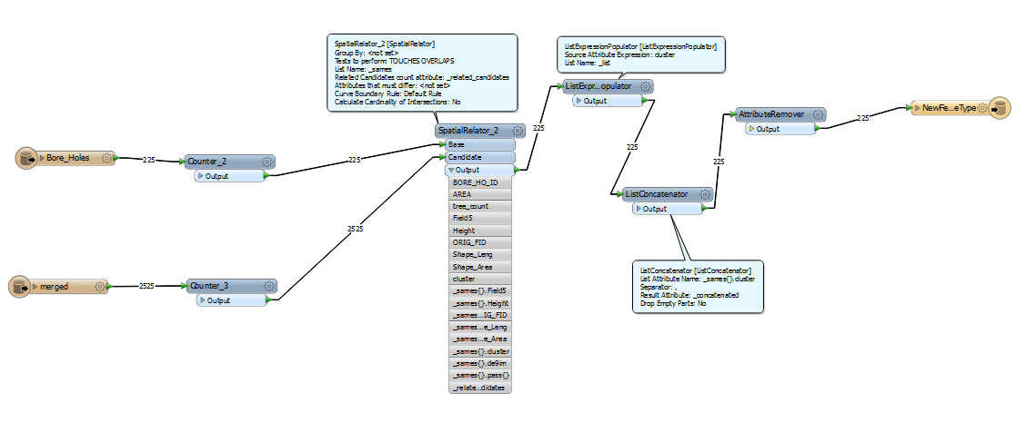
I've got a set of overlapping polygons(representing strata at different levels), and then another set of polygons on top of that(representing bore holes). For each bore hole I'd like to extract the polygons beneath in their entirety into a seperate shapefile. It is often the case that multiple bore holes will intersect the same strata, in this case I'd like the shapefiles of both bore holes to contain complete copies of the strata. Does anyone know how to do this?


I've been messing around with the spatial relator, but I'm not sure if I'm using it correctly or what to do with it's list outputs.


6 replies

Userlevel 4
Hi,


can you show us (screenshot) what you've tried so far, what you got and what you expect?


Normally you could use either the SpatialRelator or the AreaOnAreaOverlayer for this.


David
Badge +3
Hi,


A spatialrelator would do.


If u use boreholes as base, the related candidate strata will be in the list. (and visa vers).


U want the strata polygons related to the boreholes, so enter the strata as base.


Each stratum (?) wil contain the boreholes associated with it.


So when u explode the list, u have boreholes with relevant stratum(ta). U then wil end up of course with duplicate strata polygons.


Gio


Thanks for the help guys!


Gio, I used the spatial relator with the boreholes as a base, then I used  ListExpressionPopulator and the ListConcoctonator to create an attribute with a list of strata for each bore hole. Problem is I'm not really sure what to do with it now. How can I take this and use it to create shapefiles with strata polygons for each borehole?


Here's a screenshot of what I've done so far. I haven't figured out how to write the lists to a file either, just visualize them with the inspector.


David,


Here's what I have. The green circles are bore holes with buffers around them. The blue mess is strata beneath. 


For each bore hole, I'd like to seperate the strata polygons beneath it and place them into a new seperate shapefile. Making a few hundred shapefiles each consisting of the strata polygons beneath a particular bore hole. Like so:


I've used the spatialrelator so far to create a bore hole attribute with a list of each strata number. I'm not sure how to use that to cut out strata into indivudual shapefiles now.


Thanks a lot for the help.


-eayrey
Userlevel 2
Badge +17
Hi,


If you are going to write strata features into shape files, you should send strata features to Base, and send borehole features to Candidate of the SpatialRelator. Assuming each borehole has unique identifier as an attribute (e.g. ID), each output strata will have a list attribute containing related borehole ID(s). You can then create clones of a strata for every related borehole using a ListExploder, and then write them into shape files with fanout on borehole ID.


Takashi
Fantastic! It works perfectly with Takashi's method. Thank you so much for the help.

Reply