Solved

Datum transformation differences QGIS and FME osgb to wgs84


Badge
Hi all,

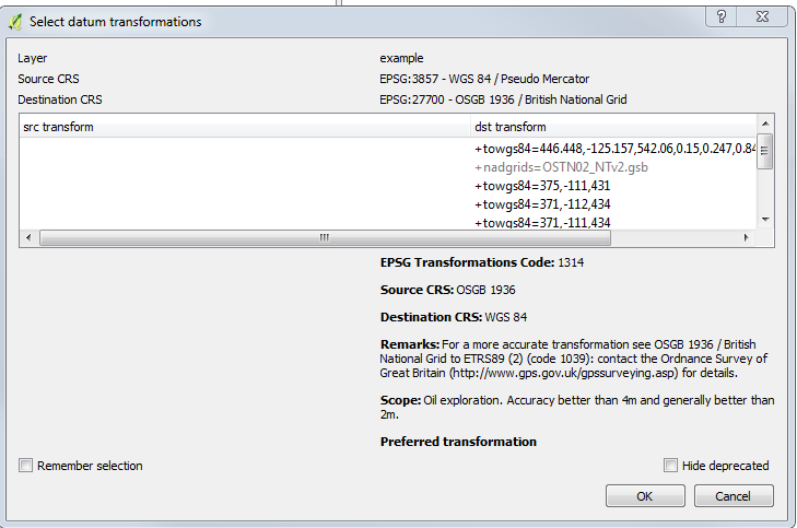
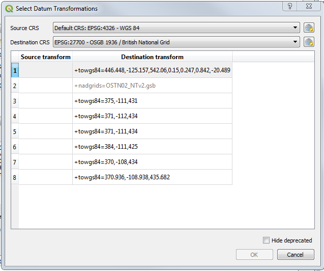
I've done some data preparation of OpenStreetMap data (epsg:4326) in QGIS and as part of that work reprojected the OSM data to epsg:27700, naughtily relying on QGIS on the fly reprojection without too much thought. That defaults to a transformation that looks good in QGIS for my purposes and aligns well with the OSM web tiles in QGIS. I now want to use the 3DTiles in FME visualisation to export the data as a Cesium web map (thus going back from epsg 27700 to 4326) but I see a shift of about 1m or 2m of my OSM data when in Cesium (i.e. the product of the FME writer). I presume this is because FME is doing a different transformation to go back (appears to default to using OSTN15 grid shift) to that which I applied in QGIS.


The QGIS transformation appears to be named as EPSG:1314. https://epsg.io/1314 so I thought I could transform the data with that to 4326, before sending to the 3DTiles writer. However, I can't find epsg:1314 as a transformation in the csMapReprojector in FME, and none of the available OSGB_to_WGS84 transforms give any better results. So do I need to recreate the transformation parameters of 1314 myself? Or is there another approach. I find it surprising that FME does not have this transformation already so I am starting to wonder if I am either missing something obvious or my approach is flawed.

icon

Best answer by daveatsafe 11 May 2018, 22:58

View original

6 replies

Userlevel 2
Badge +17

Hi @maptopixel,

I'm sorry, but this transformation is not shipped with FME, since most users want the more accurate grid transformation.

I have created a couple of definitions for you:

OSGB1936_to_WGS84_7Param - uses 7 parameter algorithm

OSGB1936_to_WGS84_Bursa - use Bursa Wolf 7 parameter approximation

I'm not sure which algorithm QGIS uses for the transformation, so I provided both. One of them should match the QGIS transformation.

Please copy the attached file into your Documents\\FME\\CoordinateSystems folder to make the transformations available to FME.

Badge

Hi @DaveAtSafe

Thank you, I think you forgot to attach the files though....

I had a go at creating a transformation definition myself using the parameters from QGIS but it has ended up with the data being way out (> 10m) so it would be interesting to see what I did wrong.

Userlevel 2
Badge +17

Hi @DaveAtSafe

Thank you, I think you forgot to attach the files though....

I had a go at creating a transformation definition myself using the parameters from QGIS but it has ended up with the data being way out (> 10m) so it would be interesting to see what I did wrong.

Hi @maptopixel,


I'm sorry about that - here is the file.


epsg1314trans.zip


Badge

Hi @maptopixel, in QGIS you have a lot of transformations even the grid transformation. Can't you discover which one you are using?

QGIS 2:


QGIS 3:

Badge

Hi @maptopixel, in QGIS you have a lot of transformations even the grid transformation. Can't you discover which one you are using?

QGIS 2:


QGIS 3:

@luigibr well I had already done a lot of FME processing after the QGIS stage that would've needed to be re-done.


Actually I didn't find a way in QGIS to view what the current OTF transform applied on to an existing project is. I had to work it out in a new project. There is a prompt when differing CRS datasets are first added (as you show) but I never worked out how to view the OTF transform later or change it to an alternative.
Badge

Hi @DaveAtSafe

Thank you, I think you forgot to attach the files though....

I had a go at creating a transformation definition myself using the parameters from QGIS but it has ended up with the data being way out (> 10m) so it would be interesting to see what I did wrong.

Thanks. That works for me. I had apparently switched up BWSCALE and ROT_Z

Reply