Solved

Need help with Rounding coordinates in LandXML output (SOLVED!!)

  • 19 September 2019
  • 9 replies
  • 5 views

Badge

Hello,

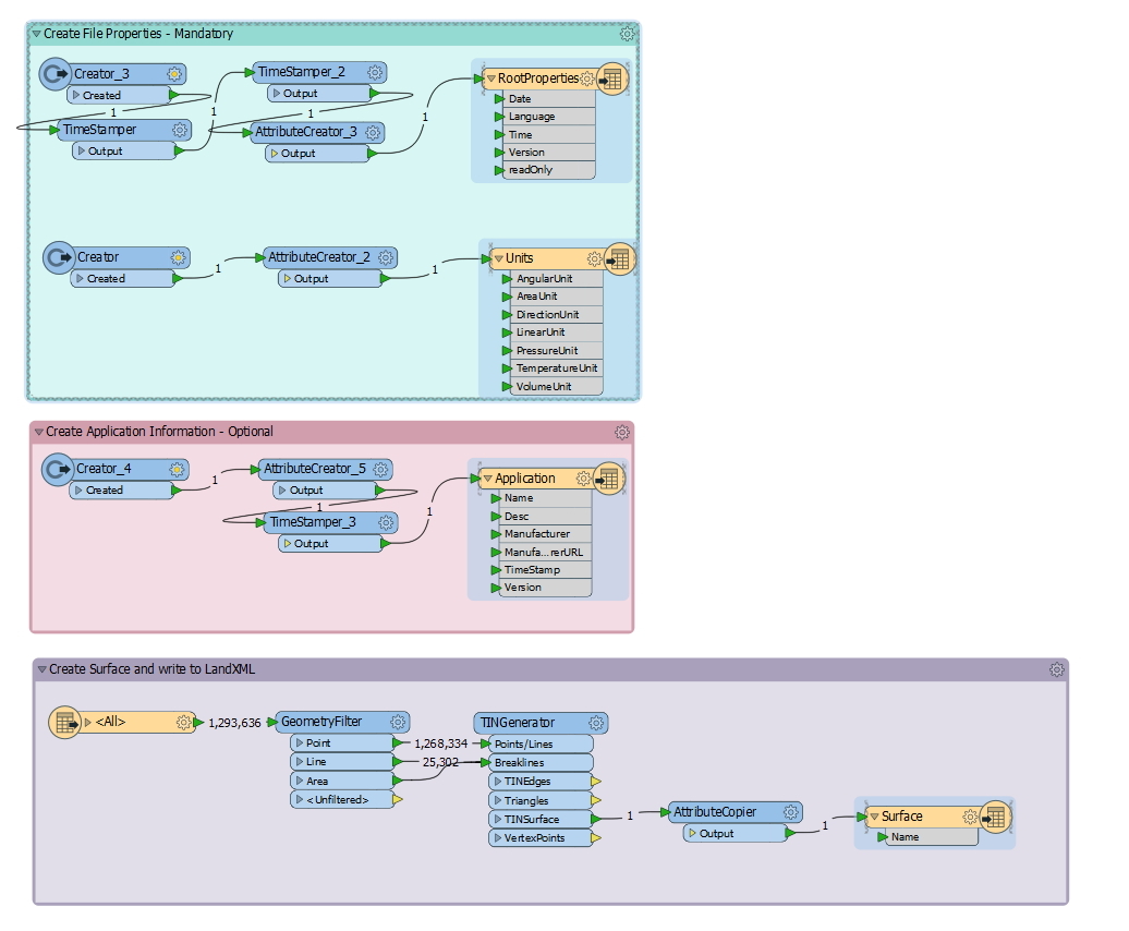
I have a workspace for converting DGN vector data into a LandXML surface file built by a fine FME support tech. It works great, but I'm now noticing that the coordinates in the output file have 10 decimal places. We really only need 3 places, which would shrink our files dramatically. I tried adding the coordinate rounder in a few places, but the final coordinates are not changing. Not sure where to look to fix it. I'm not able to add attachments or I would attach my workspace (nothing happens when I click on "attachments). Thanks!!

icon

Best answer by chrisatsafe 28 October 2019, 21:24

View original

9 replies

Badge +9

Hello @jimmy,

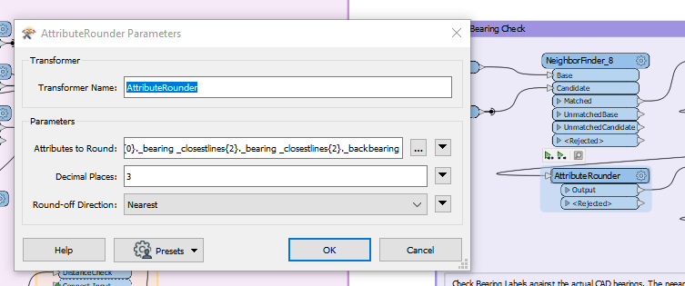
This is what I am using in a similar scenario to convert a DWG to XML

Badge

Thanks for sharing that. I can't seem to get the geometry to show in the attribute list. I'm not sure if it is treated different or if the attribute rounder will work on geometry. Seems crazy to have 10 decimal places by default. I'm a big green with FME, so might be a simple thing..

Userlevel 2
Badge +16

Seems like you are trying to round coordinates in the geometry.

In that case use the CoordinateRounder transformer.

Works as the AttributeRounder but on the geometry instead of selected attributes.

Badge

Thanks for the reply. Any idea where in this workspace it would be placed? I have tried the coordinate rounder, but I was not able to have an affect on the final output decimal places.

Userlevel 2
Badge +16

Thanks for the reply. Any idea where in this workspace it would be placed? I have tried the coordinate rounder, but I was not able to have an affect on the final output decimal places.

Looks like the only bookmark containing geometry is the bottom one.

I would add it right after the TinGenerator (as that transformer is changing the geometry it does not make sense to add it before the TinGenerator).

Hope this works for you.

Badge

I have tried both the attribute rounder and the coordinate rounder in every part of my workspace I can find. It just won't change it at all. It makes me think the LandXML writer has a hard coded precision. Since it is the writer that finalizes the file, I don't think I can do anything with it unless I create a workspace to create the XML format outside of the LandXML writer. Does that sound right? I really don't have the time/skills to do that. Seems like the LandXML writer should handle this part for me?

Badge +2

Hi @jimmy,

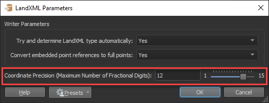
It looks like we had a report of this in our issue tracking system (FMEENGINE-30388) but the issue should be resolved as of FME 2018.1 build 18502+. The LandXML writer should now output coordinates with the specified number of fractional digits (controlled by the coordinate precision parameter). Are you able to try updating to a newer build to see if that resolves the issue? You can find the installer to the latest official release along with past releases on the FME Downloads page.

Once you have upgraded to a newer version, you should be able to set the coordinate precision in the LandXMLWriter parameters.

Hope that helps!

Badge

Hi @jimmy,

It looks like we had a report of this in our issue tracking system (FMEENGINE-30388) but the issue should be resolved as of FME 2018.1 build 18502+. The LandXML writer should now output coordinates with the specified number of fractional digits (controlled by the coordinate precision parameter). Are you able to try updating to a newer build to see if that resolves the issue? You can find the installer to the latest official release along with past releases on the FME Downloads page.

Once you have upgraded to a newer version, you should be able to set the coordinate precision in the LandXMLWriter parameters.

Hope that helps!

Yes!! That was it!! I just updated the writer and set the precision. Thanks!!! Updated to 2019.1

Badge +2

Yes!! That was it!! I just updated the writer and set the precision. Thanks!!! Updated to 2019.1

Fantastic!

Reply