Question

Colored Map of Heights difference

  • May 2, 2019
  • 3 replies
  • 37 views

Here is the sample of what I am trying to achive:


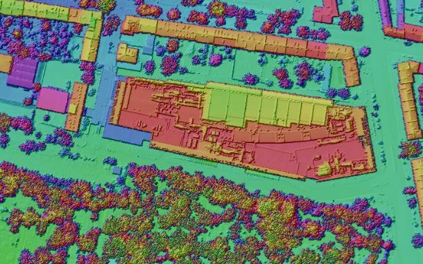
I think I do have all required data: Orthophotomap, DTM and DSM. The goal is to have different colors next to different heights. There is no classification here going on. I am struggling to find what FME tools should I use, mostly because I am not sure how is that type of map even called in English.

This post is closed to further activity.
It may be an old question, an answered question, an implemented idea, or a notification-only post.
Please check post dates before relying on any information in a question or answer.
For follow-up or related questions, please post a new question or idea.
If there is a genuine update to be made, please contact us and request that the post is reopened.

3 replies

redgeographics
Celebrity
Forum|alt.badge.img+61

You can use a RasterCellValueCalculator to subtract your DTM and DSM and you'll end up with a raster that shows the difference between the two.

Then to get different colors for different heights you could try to convert it to vector (RasterCellCoercer) and then use the GradedColorizer from the FME Hub before converting your result back to raster (ImageRasterizer or MapnikRasterizer). It'll be a bit clunky though, especially if you have a big raster.

I don't think you need the Orthophoto, except maybe to blend it in to the final result to give a bit of context.


jdh
Contributor
Forum|alt.badge.img+38
  • Contributor
  • May 2, 2019

I would use the RasterHSVShader custom transformer availabe on the hub.


If necessary you can modify it to only use the calculatedRGB values, not combine it with the hill shader.

  • Author
  • May 2, 2019

I would use the RasterHSVShader custom transformer availabe on the hub.


If necessary you can modify it to only use the calculatedRGB values, not combine it with the hill shader.

That seems to work like a charm with DSM, thanks mate