
Hi all
First time poster, long time reader of all the great advice on this forum.
using FME 2021.2.6 (work limitation)
I am currently having issues regrinding my CSAR (Raster and Pointcloud) files while keeping the lowest value in its original XY position in the regirded area.

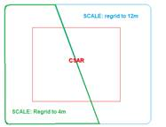
Example of regirded squares with the smallest values being picked.
Note: the gridded squares are just a visual example, I have potential looked at applying a Buffer to the soundings based on the (SCALE) area they fall into but have had no success yet.
I also have an Area file (Shapefile1) that contains the regrid values (SCALE) I would like the effected CSAR file to be regirded too.
I really have 2 issues currently affecting me that I need help with.
1) I need to be able to regrid my CSAR files (RASTER or POINTCLOUD) by keeping the lowest values in the regrided area.
2) I have a Area file (Shapefile1) that contains the regrid values I would like to implement in the overlapping area of the CSAR file (SCALE: 4m and 12m)
Any help with either of these problem would be greatly apricated.
Cheers