When i try to “inspect feature caches” or “view sources data” it does not work and i get this error message :
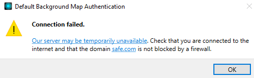
I am not able to use any defaut background map. When I click on “OK” then the software crash.
Any suggestions ?

When i try to “inspect feature caches” or “view sources data” it does not work and i get this error message :
I am not able to use any defaut background map. When I click on “OK” then the software crash.
Any suggestions ?
Hi
Which version of FME are you using and what is the background map you have?
I’m not sure if this could be related to the Stamen Background Maps Deprecation.
Do you also receive an error message in the graphics view?
I have two installations of FME Form (v2023.2 b23774 & v2024.0 b24202) on my workstation and both builds began experiencing the same issue yesterday.
Even if I create a simple workspace, with only a single Reader for an Excel spreadsheet, with no spatial component and nothing geographic to display.
After running the workspace with Feature Caching enabled the magnifying glass, or eyeball icon, will turn green, but will not display any records. After about ten minutes the “Default Background Map Authentication” warning will appear.
We have other similarly configured workstations on the same network, and they are not affected. There is something with this one workstation, and it affects both installations of FME Form Workbench.
Hi
What solved this problem for me was to add a background map in FME Options. To do it I had to add also a new connection in “Network Proxy” in FME Options (maybe this is only because of my personal configuration). Personnaly I added the WMS.GEO.ADMIN backgroundmap and it worked.
If you don’t have already done it maybe give it a try !
Thank you,
I was able to resolve this issue two ways, and one of them was by configuring a Web Service and adding a background map definition in the FME Options as you suggested.
The first method was quite simple, but might not apply to all users. By going into the Network Proxy settings I selected “Use system proxy settings” and the Default Light, Dark, and Terrain backgrounds started functioning.
The second method was more involved and comprised of:
Enter your E-mail address. We'll send you an e-mail with instructions to reset your password.