Hi pls help me with this. I just want to know which direction building is facing. I have thousands of building and i want that at once all buildings front direction should come out. The data i have are building foot print(.shp), 3d model (citygml) and road center line(.shp)

Building facade(front) direction find out


 +6
+6
- Safer
- 113 replies
-
3 February 2023

Hi @Abinash Rout, In your CityGML are you able to extract the <!--front surface--> tag? This isn't an area I'm an expert in but wondering if that would help. This documentation would be a good place to start as well.
Hi @Abinash Rout, In your CityGML are you able to extract the <!--front surface--> tag? This isn't an area I'm an expert in but wondering if that would help. This documentation would be a good place to start as well.
Thanks for replying but i just want to know if there is any transformer which will help me find direction like weather its facing south, north or south east etc.
@david_r can you pls help me with this its really urgent


 +20
+20
- Contributor
- 564 replies
-
6 February 2023

Use BoundingBoxReplacer set to 2D Oriented Bunding Box and give a name to the angle attribute.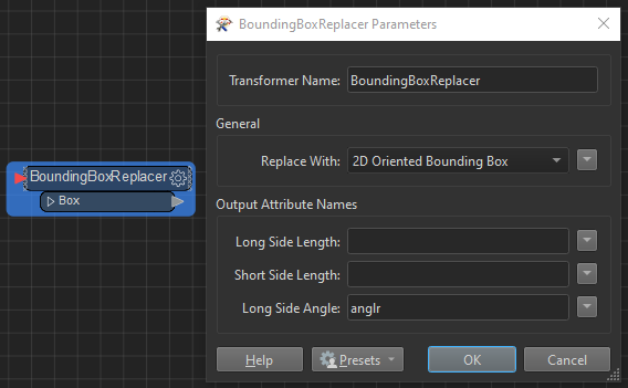 This will give you the direction of the longest side of the building, not the orientation of a specific facade.
Another method would be to use NeighborFinder with buildings as Base and roads as Candidates and use the _angle attribute to mao orientation.
Use BoundingBoxReplacer set to 2D Oriented Bunding Box and give a name to the angle attribute.This will give you the direction of the longest side of the building, not the orientation of a specific facade.
Another method would be to use NeighborFinder with buildings as Base and roads as Candidates and use the _angle attribute to mao orientation.
@caracadrian thank you so much.So from angle how will i identify the direction east, west or north-east etc.


Userlevel 4
- 8177 replies
-
6 February 2023

@david_r can you pls help me with this its really urgent
Sorry, this is outside my area of expertise.
Sorry, this is outside my area of expertise.
okay thanks for reply
Use BoundingBoxReplacer set to 2D Oriented Bunding Box and give a name to the angle attribute.This will give you the direction of the longest side of the building, not the orientation of a specific facade.
Another method would be to use NeighborFinder with buildings as Base and roads as Candidates and use the _angle attribute to mao orientation.
@caracadrian pls explain the second method you suggested
+20
- Contributor
- 564 replies
-
6 February 2023
@caracadrian pls explain the second method you suggested
Just input building footprints and road lines into NeighborFinder and use AttributeRangeMapper or AttributeManager to set geographic direction from angle value. I believe the angle is measured counterclockwise starting from the X axis - 45-135 degrees should mean north. Reading the Help helps NeighborFinder (safe.com)
@caracadrian pls explain the second method you suggested
@caracadrian Thank you so much forgot to thank you 😅 . achieved what i was looking for
+20
- Contributor
- 564 replies
-
14 February 2023
@caracadrian pls explain the second method you suggested
Glad you found a solution. Happy to help!
Reply
Enter your username or e-mail address. We'll send you an e-mail with instructions to reset your password.