
Hi.
JPG photo from a DJI drone contains coordinates in the EXIF but is not displayed in the correct location.


 +6
+6
Hi.
JPG photo from a DJI drone contains coordinates in the EXIF but is not displayed in the correct location.

 +6
+6
Hi @gvenhorst, sounds like you need to play with the coordinate system of your JPG. Here is a great article to get your started with manipulating coordinate systems: https://community.safe.com/s/article/using-coordinate-systems-within-fme
+6
Hi,
Have already tried various settings and read documentation, but the DJI has a slightly different Exif info.
Whichever setting I use, the top left corner of the photo will always be at coordinate 0.0.


 +25
+25
Hi,
Have already tried various settings and read documentation, but the DJI has a slightly different Exif info.
Whichever setting I use, the top left corner of the photo will always be at coordinate 0.0.
Can you post a screenshot of the EXIF information you're getting?
+6
Can you post a screenshot of the EXIF information you're getting?
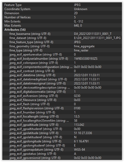
Hoi,
Hierbij een screenshot.
+25
Can you post a screenshot of the EXIF information you're getting?
Just as I thought, the latitude/longitude are given in WGS84, degrees, minutes and (decimal) seconds. You need to use an AttributeSplitter, with a space as separator character, first to separate them into list elements and then a DecimalDegreesCalculator to turn them into decimal degrees.
Then an Offsetter or Georeferencer to turn your jpg into a georeferenced one (although if it's supposed to be a top-down photo and the drone wasn't completely level when the photo was taken that might be a whole other ordeal).
+6
Can you post a screenshot of the EXIF information you're getting?
Hi,
Thank you for thinking along.
Converting the coordinates works well (had already tried that before).
But the next step keeps going wrong.
Or I come from somewhere in the sea or in Africa.
The photo was taken in the Netherlands, Limburg.
If I look up the coordinates on the map, I get to the right place.
N51.17425933333333 E6.021244194444445
+25
Can you post a screenshot of the EXIF information you're getting?
Okay, then a CoordinateSystemSetter, using LL84 as the coordinate system, should do the trick.
+6
Can you post a screenshot of the EXIF information you're getting?
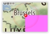
Hi,
Had tried that
The top left corner is in the right place but the grid is now much too large
+25
Can you post a screenshot of the EXIF information you're getting?
Do you have more information in the exif data? I see an altitude in there as well, along with the focal length that should tell you something about the size of the image on the ground, but even then I think that's not quite enough yet.
+6
Can you post a screenshot of the EXIF information you're getting?
Hi,
Can I email you the photo and fme model?
+25
Can you post a screenshot of the EXIF information you're getting?
I think it's better if you post them here so that others can try and help you. I'm not sure I have the answers for you (as we're getting into photogrammetry here and that's not my strong side), nor the time what with the holidays.
In addition to that, if somebody here provides the correct answer and others find this thread later on they might be helped by it too.
Enter your username or e-mail address. We'll send you an e-mail with instructions to reset your password.

