Solved

I want Download from web


Badge +5

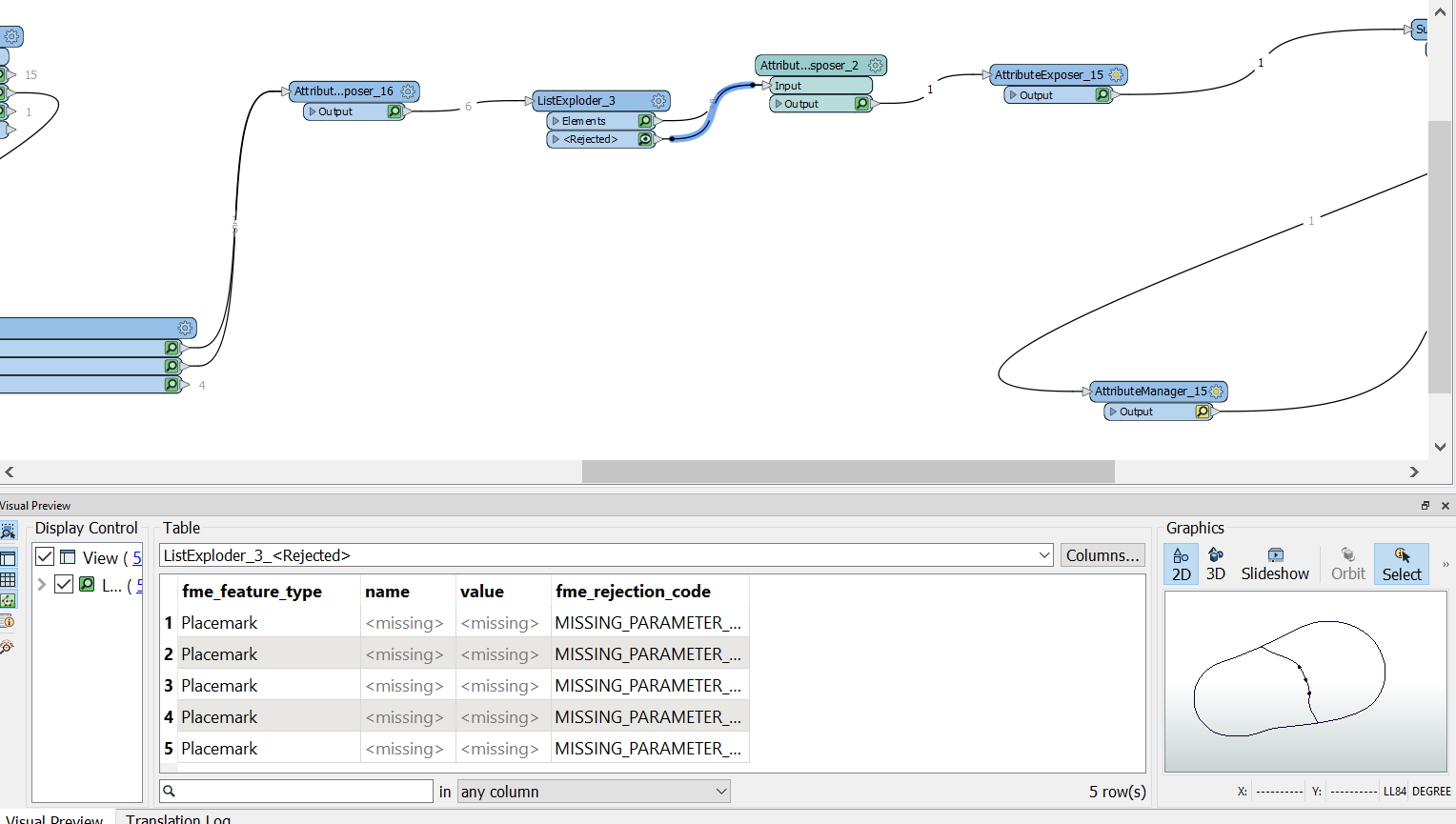
I create the workspace but problem is its getting first one but what i need is get the latest one.


also the file is KMZ and i cant get the Placemark where all location is stored please help me out in this


https://www.nhc.noaa.gov/gis/


I am attaching the workspace

icon

Best answer by redgeographics 27 June 2022, 09:58

View original

17 replies

Userlevel 5
Badge +25

Your StringSearcher is only returning the first match, but there are many. If you check in its parameters you can set a "all matches list name" under the Advanced section, do that and you'll get a list of, in this case, 88 matches.

I'm not familiar with the naming convention of these files though, so I'm not entirely sure which would be the latest one.


Then as for the KMZ placemarks, the FeatureReader is reading a dynamic filename, so when you're designing the workspace it doesn't actually know what that file is like. You can work around that by downloading one of the files first and use that to develop the workspace, then switch it back to a dynamic filename when you're done. Alternatively, you can manually specify which output port(s) you want it to have.

Badge +5

AL012022_017adv_most_likely_toa_34.kmz

this is the latest one

https://www.nhc.noaa.gov/storm_graphics/api/AL012022_017adv_most_likely_toa_34.kmz

I am new on fme i dont know how can i do that


Badge +5

there are datasets and each dataset have storm in each area

like Atlantic Eastern Pacific Central Pacific

in each storm file name AL012022_017adv_most_likely_toa_34.kmz

only chnage is 012018

022018


each storm have numbers after Area alpha code and year so i need by numbers and current year

Badge +5

I am new in FME please help me Out

Userlevel 5
Badge +25

So...

AL01 = Atlantic

2022 = year

and then they're numbered consecutively?

Badge +5

Yes ..


So Atlantic = AL

Eastern Pacific  = ep

Central Pacific - cp


so each area will be seprate work space


Badge +5

you can see here


https://www.nhc.noaa.gov/gis/archive_forecast.php?year=2022

Badge +5

Ep have three storm till now so they give the numbers how many storm have in that area

Badge +5

and one more thing


this KMZ file should convert from KMZ to Shapefile..

Userlevel 5
Badge +25

But in the matches list I see a different naming structure:

AL312020_most_likely_toa_34_latest.kmz


What you can do, once you have that naming structure clear, is:

  • Use an AttributeCreator to create region, year and number attributes using the SubString fuction
  • Sort by year and number
  • Use a Sampler, grouping by region, to get the last storm.
Badge +5

Sorry i gave you wrong file name


AL312020_most_likely_toa_34_latest.kmz (This one is correct)


as i said i am new on FME

Badge +5

problrm is i am not able to get the latest storm from web

Userlevel 5
Badge +25

problrm is i am not able to get the latest storm from web

Have you tried to follow the steps I outlined above?


Schermafbeelding 2022-06-24 103046
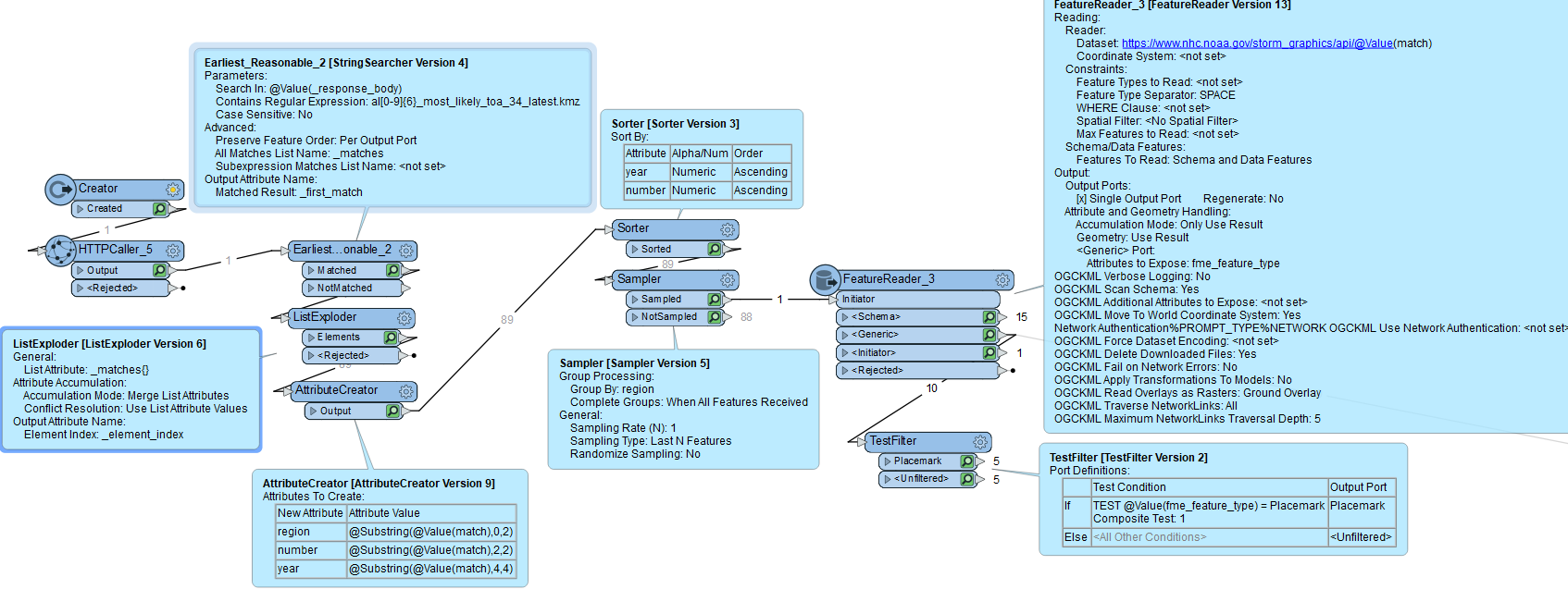
This should do the trick for getting the last storm.

Badge +5

Its work but problem is there is data as well under the document when i get placemark and document everything working fine but whn i load to Arcgis portal i get the data but not placemark why is that

Badge +5

image

Badge +5

But in the matches list I see a different naming structure:

AL312020_most_likely_toa_34_latest.kmz


What you can do, once you have that naming structure clear, is:

  • Use an AttributeCreator to create region, year and number attributes using the SubString fuction
  • Sort by year and number
  • Use a Sampler, grouping by region, to get the last storm.

how can i get only current year Storm

Userlevel 5
Badge +25

how can i get only current year Storm

Once you have the year in a separate attribute you can use a TestFilter to do that, like this:Schermafbeelding 2022-06-27 095809

Reply