Solved

The script in FME server won't create Geopackage files

  • 25 October 2021
  • 8 replies
  • 22 views

Badge +1

Hi,


I have a script that I want to use in FME server. The script is creating vertexpoints from an excelfile and the outcome is points with relevant attribute. However when I run the script in my FME desktop and attach a geopackage writer that saves a file locally it creates the points without a problem. But in FME server nothing happens which is strange since it does create other polygons in the geopackage file. But the vertexpoints that are created in the script are not created in their respective geopackage file. Does anyone know why?


I have attached the fme script.

icon

Best answer by souryana 24 November 2021, 09:51

View original

8 replies

Userlevel 5
Badge +25

When you published the workspace, did you specify Job Submitter as the service or Data Download?

Badge +1

Data downloader. But as I specified in my question, the script in FME server does not have problem creating other geopackage files for polygons except for points that are created with vertexcreator in the script. I tried to use Coordinatesystemsetter to specify the coordinatesystem but without any success.

Userlevel 5
Badge +25

Okay, just to make sure: FME Server can actually access those Excel files, right (it's just that in the workspace the file paths indicate they're stored in somebodies Windows user profile)

Are you getting any error messages in the job log?

Badge +1

Yes FME server can access those Excel files (drag and drop). But the problem lies when I want to write to a geopackage in FME Server. The vertexpoints that area created in the script wont be created in the Geopackage file. I have attached the logfile.

Badge +1

Yes FME server can access those Excel files (drag and drop). But the problem lies when I want to write to a geopackage in FME Server. The vertexpoints that area created in the script wont be created in the Geopackage file. I have attached the logfile.

Please ignore error messages like "Value of field 'info1' has 26 characters, whereas maximum allowed is 6." I have tried to change it without any success of writing to the geopackage file.

Badge +1

@Hans van der Maarel​ have you had the time to read the logfile?

Badge +1

When I read the logfile I find something weird. When the script is writing to the geopackage file for my vertexpoints the logging looks like this:

image
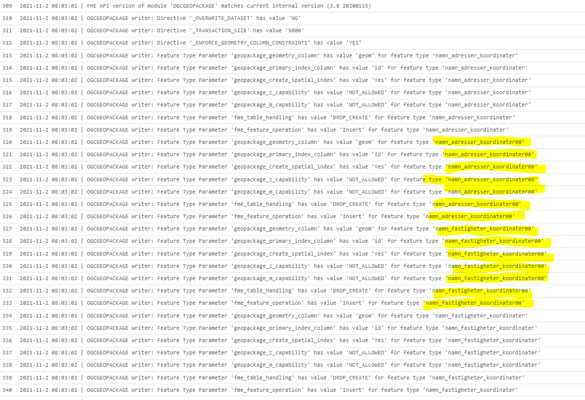
Does anyone know why its adding featuretype namn_adresser_koordinater00 and namn_fastigheter_koordinater00? Why the 2 "00" in the end. I just dont understand it. My feature types are called namn_adresser_koordinater and namn_fastigheter_koordinater.

Badge +1

Hi,

The problem with this issue was a difference in versions between workbench and server. I have FME server version 2020.3 and FME workbench 2020.2. However the new excel columns that I added in the reader in FME workbench 2020.2 is not compatible with FME server version 2020.3. The solution was to upgrade my FME workbench to 2020.3 (same version as FME server).

Reply