")
As stated, I am trying to add both geodb_polygon & geodb_attributes readers, and polygon gets added twice. Everything under General is grayed out and I am unable to change 'Allowed Geometries' on one of them to geodb_attribute. Geodb's were created using Arc 10.8.1


Userlevel 6
 +32
+32
- Celebrity
- 2337 replies
-
22 October 2021

I really don't understand what you are trying to do... can you share your workspace or a screenshot?
Sorry this took a few days to get back to., let me try and explain. I had a .gdb that I was able to extract attribute information from, and now I am only able to see the polygon type. The box where I could select the dropdown is grayed out. I can no longer select 'geodb_attributes'. The only that happened while this successfully worked was that we went from named users for our company's ArcGIS Pro deployment to a concurrent license server, although I am not sure this has any bearing on this issue. Before, I was able to successfully pull land parcels from a .gdb and populate an autocad file with both the linework and a created a parcel label within.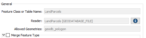

Userlevel 2
 +10
+10
- Safer
- 459 replies
-
2 November 2021

Sorry this took a few days to get back to., let me try and explain. I had a .gdb that I was able to extract attribute information from, and now I am only able to see the polygon type. The box where I could select the dropdown is grayed out. I can no longer select 'geodb_attributes'. The only that happened while this successfully worked was that we went from named users for our company's ArcGIS Pro deployment to a concurrent license server, although I am not sure this has any bearing on this issue. Before, I was able to successfully pull land parcels from a .gdb and populate an autocad file with both the linework and a created a parcel label within.
Hi @jgary, unfortunately sometimes the licensing levels of ArcGIS are not read in correctly, causing the problem you're seeing here. This is especially true if you have multiple versions of ArcGIS (ArcMap & ArcGIS Pro) Installed. However, I do have a few suggestions & questions to try and troubleshoot this:
- This article is a good place to start. It outlines the issues you're having here and the many ways you can go about solving it: https://community.safe.com/s/article/geodatabase-formats-missing-greyed-out-or-have-unm
- What licensing version is your ArcGIS licensed for? You can check this in the ArcGIS Administrator or in the Settings of ArcGIS Pro.
- This article also provides some more thorough details on FME Versions and ArcGIS Compatibility: https://community.safe.com/s/article/notes-on-fme-and-esri-versions-and-compatibility
Thanks for the articles, I will post back here once I am able to confirm a solution.
Still trying to find troubleshoot this on my end without much luck, but some more parameters from here are might be helpful:
1) We are running FME Desktop Oracle Edition 64-bit (software installed locally) w. a Floating License.
2) ArcGIS 10.8.1 Advanced Concurrent Use and Pro (both software installed locally) w. a license manager being used to manage licenses.
**The FME and GIS licenses appear to be on different servers within our organization.
Might this be the cause for my licensing issues?
Reply
Enter your username or e-mail address. We'll send you an e-mail with instructions to reset your password.