

Creating reader for format: GeoTIFF (Geo-referenced Tagged Image File Format)
Trying to find a DYNAMIC plugin for reader named `GEOTIFF'
Loaded module 'GEOTIFF' from file 'C:\\Program Files\\FME_2018\\plugins/gdal/GDAL.dll'
FME API version of module 'GEOTIFF' matches current internal version (3.8 20180604)
GEOTIFF reader: Opening file '//client/F$/DEM_LIDAR_2012-2020_1m/citywide/DEM_LIDAR_2012-2020_1m_citywide.tif'
GEOTIFF reader: TIFFFetchDirectory://client/F$/DEM_LIDAR_2012-2020_1m/citywide/DEM_LIDAR_2012-2020_1m_citywide.tif: Can not read TIFF directory count
GEOTIFF reader: TIFFReadDirectory:Failed to read directory at offset 8081121040
GEOTIFF reader: Failed to open the dataset '//client/F$/DEM_LIDAR_2012-2020_1m/citywide/DEM_LIDAR_2012-2020_1m_citywide.tif'. Please ensure source data is valid and correct reader is selected
A fatal error has occurred. Check the logfile above for details
Failed to obtain any schemas from reader 'GEOTIFF' from 1 datasets. This may be due to invalid datasets or format accessibility issues due to licensing, dependencies, or module loading. See logfile for more information
FME Session Duration: 0.2 seconds. (CPU: 0.1s user, 0.0s system)
END - ProcessID: 4808, peak process memory usage: 49480 kB, current process memory usage: 37888 kB
Failed to obtain any schemas from reader 'GEOTIFF' from 1 datasets. This may be due to invalid datasets or format accessibility issues due to licensing, dependencies, or module loading. See 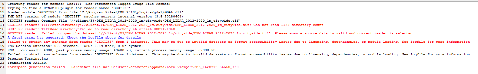 logfile for more information
Program Terminating
Translation FAILED.
Workspace generation failed. Parameter file was C:\\Users\\dcameron\\AppData\\Local\\Temp\\7\\FME_1628712856560_440


