Question

ESRI repojector appears not to be reading field value correctly


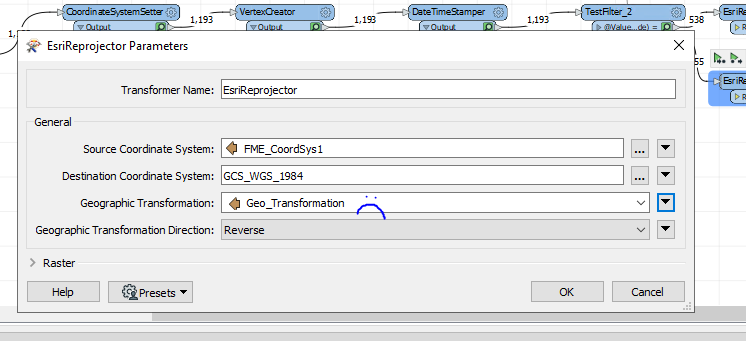
I have input points with multiple coordinate systems. I am trying to use esri reprojector on them, using a table for the input and output coordinate system and the geographic transformation.

After MUCH testing, it appears to me that the geographic transformations are not being read. I hard-coded the identical value that is in the table and the features ended up where I wanted. When I set the value to get read from the table, they don't. I am pretty sure I've entered it correctly.

Note: since I ran successfully with a hard-coded value, after switching to reading the table value it is working correctly. Logical explanation is that it is not reading the table.

Input coord is read from table. Output coord sys is hard coded (wgs 1984), geographic transformation appears to be ignoring table values.


3 replies

Userlevel 4
Badge +26

Could there be a space in your table value at the beginning or end? That could explain the issue. Perhaps you can upload a simple workspace which reproduces the issue

Thanks for the reply. The data is sensitive, so I'd have to alter it and not sure when I'd have time. I have copied the geographic transformation values from the lookup table and pasted them into the esrirreprojector and it works, so I think they are correct.

This appears to be just an issue with the geographic transformation. It's getting the coordinate system right. I'm noticing coordinates are off for EITHER one datum or the other (spot-on in one place, off by several meters in another or vice versa), but the coord system is correct. If the coordinate system were off, the points would be MUCH further off the correct location.

I've been investigating this to death and I am convinced that the esrireprojector does not read geographic transformation values correctly from a field in a table. I have very consistently been unable to get the geographic transformation to work by reading it from a table, but it does consistenly work when I entered it manually. The manual entry was entered by copying the value in the field, so the values are correct. The table will read coordinate systems correctly.


Since I have data with more than one datum, I had to break out data by datum, plug it into the esrireprojector, read the coordinate system from a field and enter the geographic transformation manually.


This works :

 manualThis does not work (The value in the 'Geo_Transform' field is correct):
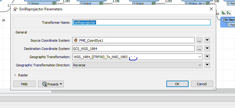
field

Reply