i would like to reduce the features from dgn file to write in Adobe Geospatial PDF , any ideas please .
thanks in advance .

 +3
+3
i would like to reduce the features from dgn file to write in Adobe Geospatial PDF , any ideas please .
thanks in advance .


 +30
+30
Hi @spiderman
There is the transformer Sampler that you can work with sample of data.
https://www.safe.com/transformers/sampler/
Thanks in Advance,
Danilo
+3
Hi @spiderman
There is the transformer Sampler that you can work with sample of data.
https://www.safe.com/transformers/sampler/
Thanks in Advance,
Danilo
Thanks alot, i used it but i found the pdf output still slow to open and load the layers .Do you have a solution to speed the pdf up to show the output .

 +11
+11
Hi @spiderman, what kind of geometry is coming from the DGN? Depending on the geometry types there are some transformers that you can use to join line segments, dissolve areas, generalize, or otherwise simplify data for writing. I'm a bit surprised that the output would be too big for pdf as I've had success in the past bringing large BIM files (building information models) into 3D PDF, though a bit of a different pdf format.
+3
Hi @spiderman, what kind of geometry is coming from the DGN? Depending on the geometry types there are some transformers that you can use to join line segments, dissolve areas, generalize, or otherwise simplify data for writing. I'm a bit surprised that the output would be too big for pdf as I've had success in the past bringing large BIM files (building information models) into 3D PDF, though a bit of a different pdf format.
DGN File is Polygon include some streets .Do you have an example for workbench that you worked on DGN file and u succeded to write in pdf .Thanks alot for help
+11
DGN File is Polygon include some streets .Do you have an example for workbench that you worked on DGN file and u succeded to write in pdf .Thanks alot for help
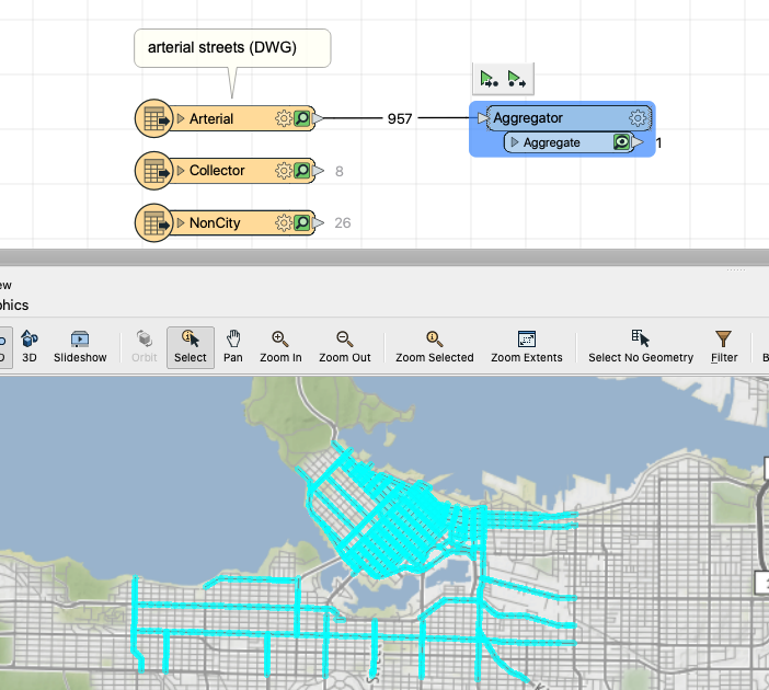
@spiderman, sorry for the late reply! Could you try writing to 3D PDF? I was re-reading this thread and I had a hard time picturing a file that was too big for pdf to handle. I've written some big Revit files(building information models) to 3D PDF with no problem in the past, so I'm wondering if perhaps 3d pdf may be a better option for you?
If you want to stick with the Geospatial pdf, consider aggregating your features using an Aggregator so there are fewer individual geometries written to pdf if it's not important to your output to be able to distinguish between them. I think the aggregator could make a pretty good difference. For example you could have all your streets as one feature for example rather than a few thousand features like the screenshot below:
Enter your username or e-mail address. We'll send you an e-mail with instructions to reset your password.

