Question

Geospatial pdf output is not responding to open .

  • 27 January 2021
  • 3 replies
  • 3 views

Badge +13

after saving the output of my workbench (Geospatial pdf ), i found it is too slow to show the included data inside the pdf and sometimes it is not responding .

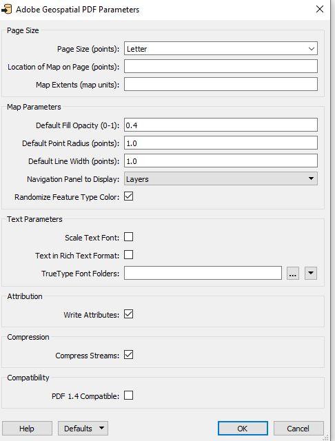
so my question how could i save pdf file and let the output file working quickly without any problem ?should i change sth in parameter of pdf writer?

my expected output as several lines and points inside polygon .

Aobe Geospatial Pdfanother question relates to the output ,lines are not clear at pdf file ,how could i change the scale of output to show lines clear in pdf without zooming .


Thanks for help


3 replies

Userlevel 5
Badge +25

Couple of things:

  • How much data (number of features) are you writing to PDF? Lots of data means it'll be slow to process in Acrobat reader
  • PDF is a page-based format, you can set the page size to a preset (Letter, Legal, A4, A3 etc) or a points size, eg. 1000x1000. It's measured in points, 1 point is 1/72 inch. Line widths are measured in points as well, if your page size is very large and your screen is small, a 1-point line will be very hard to see (although printed on paper a 1-point line is just fine)
  • The PDFPageFormatter can be used to determine which part of the page can be covered with data.

Page size and extents of data determine the scale eventually. Always keep in mind PDF is designed to be a "paper" format.

Badge +13

Couple of things:

  • How much data (number of features) are you writing to PDF? Lots of data means it'll be slow to process in Acrobat reader
  • PDF is a page-based format, you can set the page size to a preset (Letter, Legal, A4, A3 etc) or a points size, eg. 1000x1000. It's measured in points, 1 point is 1/72 inch. Line widths are measured in points as well, if your page size is very large and your screen is small, a 1-point line will be very hard to see (although printed on paper a 1-point line is just fine)
  • The PDFPageFormatter can be used to determine which part of the page can be covered with data.

Page size and extents of data determine the scale eventually. Always keep in mind PDF is designed to be a "paper" format.

Thanks ,i understand bettter now the problem .i had too much features but i reduces it to 10000 and pdf is ok now .

could i ask , what u prefer when u want to print a map ( polygon include lines ,streets,etc . ) which scale u do ?

and when there is a gap as streets and have special color at both sides ,i can see the gap good in inspector but at pdf i found color at both side fill the gap .and the gap is not any more clear . how could i solve that ?

How could i let pdf have a nice scale and show me the output as in inspector if it is possible ?

could i change specific lines to dash line to appear at pdf as dash ? .thanks for help

Userlevel 5
Badge +25

Thanks ,i understand bettter now the problem .i had too much features but i reduces it to 10000 and pdf is ok now .

could i ask , what u prefer when u want to print a map ( polygon include lines ,streets,etc . ) which scale u do ?

and when there is a gap as streets and have special color at both sides ,i can see the gap good in inspector but at pdf i found color at both side fill the gap .and the gap is not any more clear . how could i solve that ?

How could i let pdf have a nice scale and show me the output as in inspector if it is possible ?

could i change specific lines to dash line to appear at pdf as dash ? .thanks for help

You can use PDFStylers to style features, layer order is another thing to consider.

Scale depends on the level of detail of your data and the page size you set. For a usable "street" map a scale of 1:10.000 to 15.000 is most useful.

If you can share some images of the output you have now and how you'd like to improve that it'll be easier to come up with useful suggestions.

Reply