Solved

Creating mapsheets along a line


Badge +6

Hi Guys,


another challenge...I've tried many things but i didnt get right output...


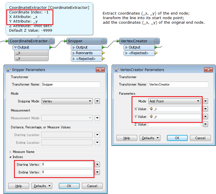
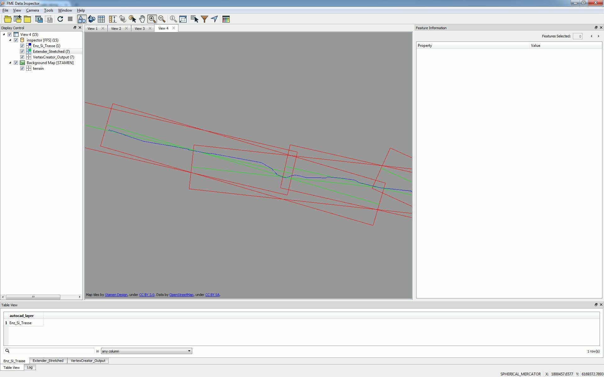
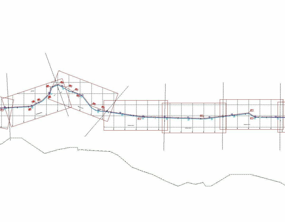
I have aline (screenshot blue line) and i want create mapsheets (red fixed width fixed height) along the line....how can i do that? (screenshot)

Thanx and Greetz


Franco
icon

Best answer by takashi 10 February 2016, 12:23

View original

11 replies

Userlevel 2
Badge +17

Just an idea. Assuming that the longer side length should be 1000m and shorter side length should be 500m.

  1. Divide the line with the LineDivider (FME Store) by 950m or so.
  2. Extract the coordinates (e.g. x, y) of the end node for each divided line with the CoordinateExtractor.
  3. Transform each divided line into start node point with the Snipper. Snipping Mode: Vertex, Starting Vertex: 0, Ending Vertex: 0
  4. Add the coordinates (x, y) to the point with the VertexCreator (Mode: Add Point). Here, line segments (straight lines) connecting between the start and end nodes for each divided line have been created. Approx length would be 900m or so, maybe...
  5. Extend the the line segments with the Extender. Extension Length: (1000-@Length())*0.5
  6. Finally use the Bufferer to transform the stretched lines (length = 1000) into rectangular polygons. Buffer Amount: 250 (i.e. 500 x 1/2), End Cap Style: None.

Hope this helps.

Badge +6

Hi Takashi,


point 3 and point 4 is not so clear for me....where do the straight lines be generated?


can u give me a screenshot of the transformers on point 3 and poin4?


That would help me a lot...Thanks for your quick answer


Greetz

Franco

Userlevel 2
Badge +17

Hi Takashi,


point 3 and point 4 is not so clear for me....where do the straight lines be generated?


can u give me a screenshot of the transformers on point 3 and poin4?


That would help me a lot...Thanks for your quick answer


Greetz

Franco

Hope this screenshot helps you.

Badge +6

Hi Takashi,


the workflow works very good but not to 100% perfect BECAUSE: (screenshot)

BLUE: the route


GREEN: The Output from EXTENDER


RED: The Mapsheet Outputs


As you see the extended lines(green) loses the direction aof the line....perfect would be if the mapsheet has a rotation that the route (blue would enter nearly half the short side on the mapsheet)

BUT: it's nearly perfect and it helps me a lot........


I know that ARCGIS has this tool (Toolbox) under Category Cartography Tools/Data Driven Pages......STRIP MAP INDEX FEATURES....(maybe there is a way to take this functionality)

Thanx


Franco


Userlevel 2
Badge +17

Hi Takashi,


the workflow works very good but not to 100% perfect BECAUSE: (screenshot)

BLUE: the route


GREEN: The Output from EXTENDER


RED: The Mapsheet Outputs


As you see the extended lines(green) loses the direction aof the line....perfect would be if the mapsheet has a rotation that the route (blue would enter nearly half the short side on the mapsheet)

BUT: it's nearly perfect and it helps me a lot........


I know that ARCGIS has this tool (Toolbox) under Category Cartography Tools/Data Driven Pages......STRIP MAP INDEX FEATURES....(maybe there is a way to take this functionality)

Thanx


Franco


Hi @franco69, the dividing length you have set to the LineDivider might be too short comparing to the required longer side length.

Badge +6

Hi Takashi,


yup...i will try this.....Thx very much!!!


Cheers


Franco
Badge +6

Hi Takashi.....


i don't know if I do something wrong, but i think the fault is somewhere else...


because the mapsheets have different lengths.....


but i need them all exactly the same because they have to fit in a data frame in ARCGIS...


i think to create a line with two vertices is not the way because then the original length is not given any more and after the extender the lengths are not the same??


Hmm...any solutions? or is it doing well in your workbench??


Thx FRanco
Userlevel 2
Badge +17

@franco69, I haven't execute the data flow. Try the attached workspace with your data.

create-mapsheets-prototype.fmw

Badge +6

@takashi...fine...now it works...maybe i've set the params wrong


Thx
Badge +3

for a data frame in ArcMAp?

Why not use mapbook in ArcMap. You can create ribbons in there you know ( even when it was a plug_in one could do that).

Badge +6

@gio....no not for ArcMap....the workbench is for different systems...but the output is not only to create mapsheets....line is input (can be KML,dwg,etc.....) the output is all you can create automatically...

but thanks Gio

Greetz

Franco

Reply