Question

Convert classified .mrr grid to polygons


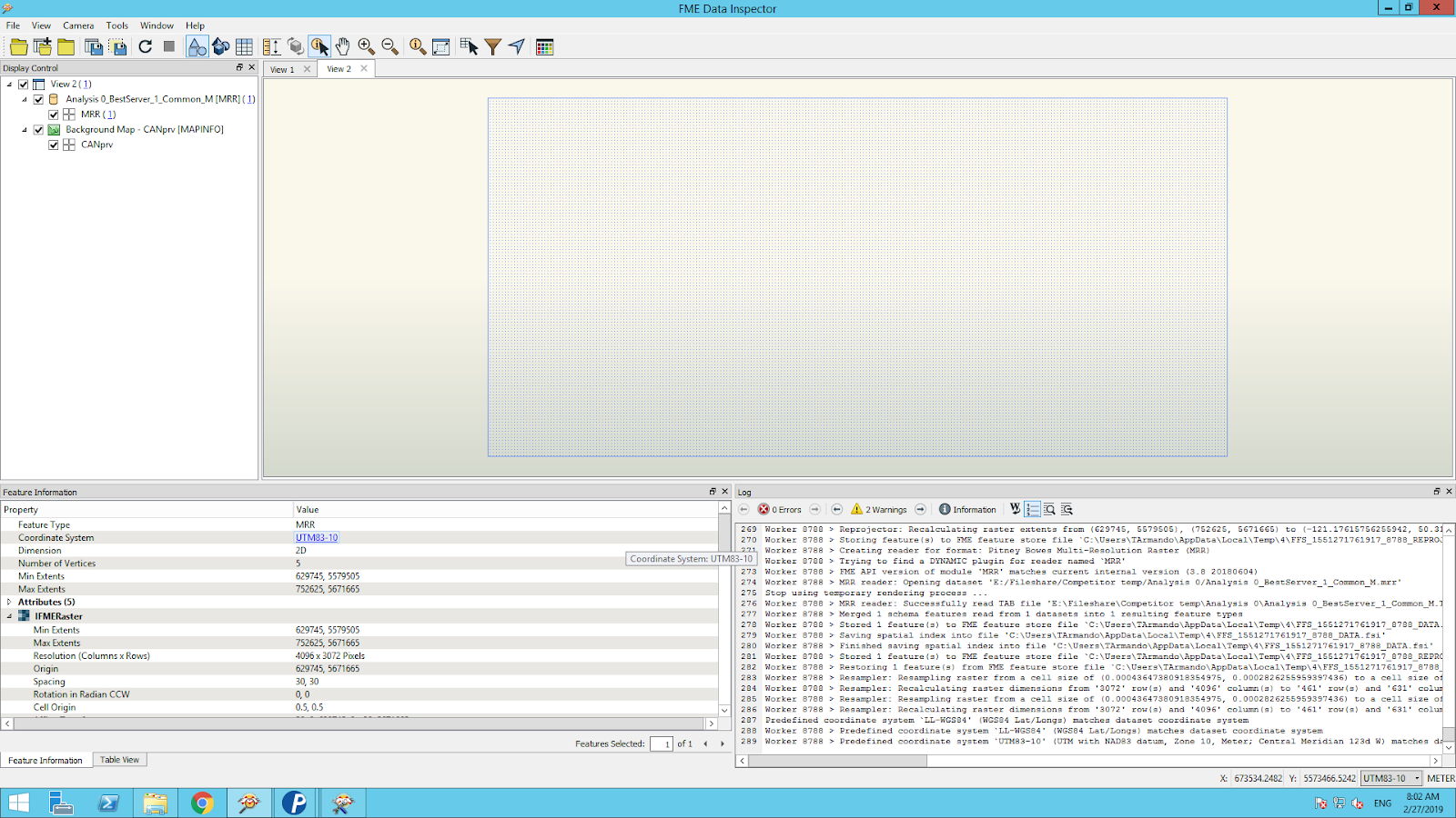
I'm new to FME, but we brought it in to manage the new Mapinfo .mrr grids we were getting. I'm having a few problems getting my head around it though.

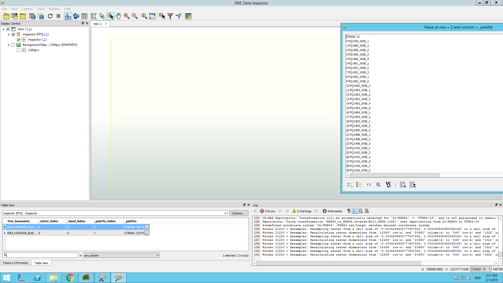
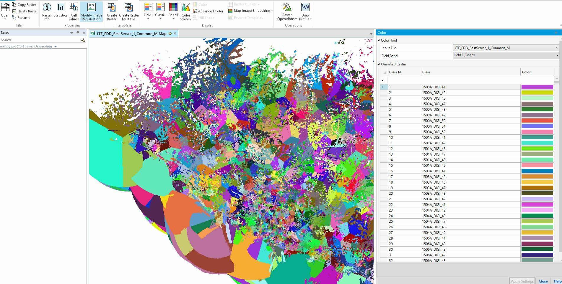
I'm trying to contour a classified .mrr file, with One band (0) and two Palettes (0,1).

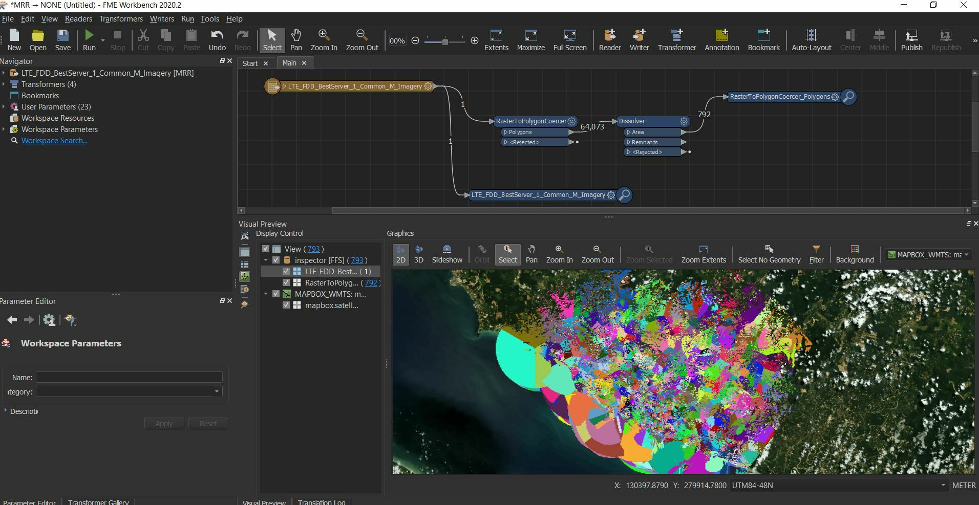
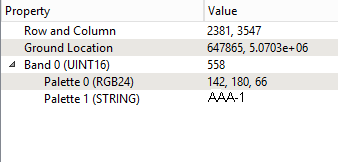
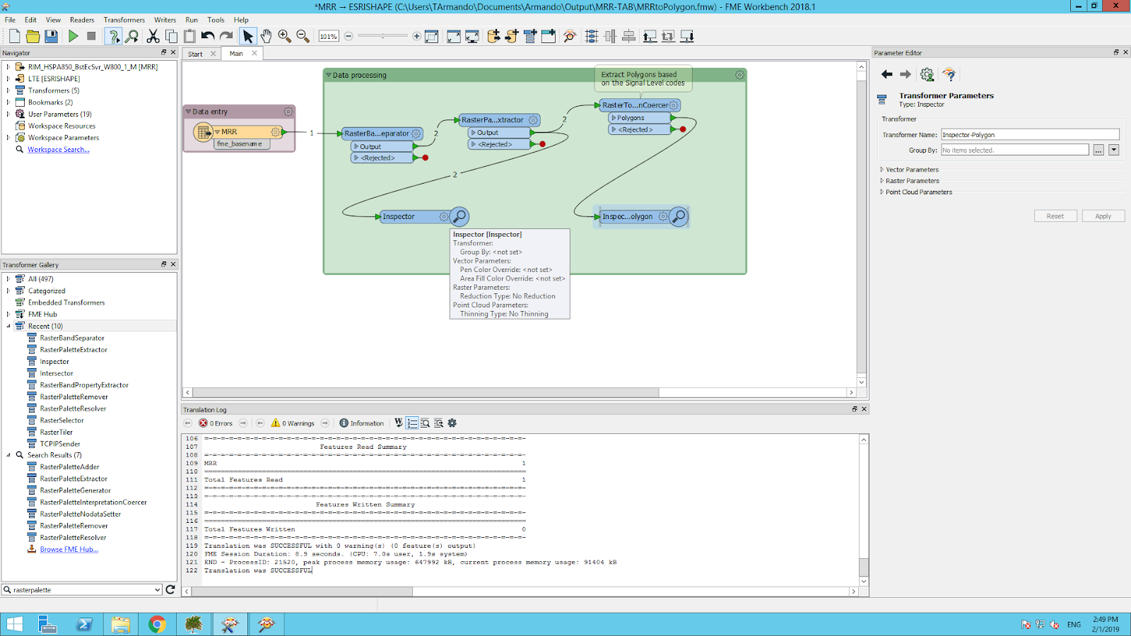
I want to write polygons with the Palette 1 string values(eg. AAA-1, AAA-2, AAB-1, AAC-1) so I used RasterSelector to pick band 0 and Palette 1 the RasterToPolygonCoercer to create a .tab polygon file. It writes the polygons correctly but assigns BAND 0 value not the palette value.

What do I need to do to expose the Palette value?

Edit:


I'm using RasterPaletteResolver on the grid but it seems to crash on a <Rejected> feature...

Palette Keys -> Values : Band 3 : Palette 0 : 2195 -> AAA-1


Palette Keys -> Values : Band 3 : Palette 0 : 2196 -> AAB-1


===========================================================================


RasterPaletteResolver_<Rejected>(TeeFactory): RasterPaletteResolver_<Rejected>: Termination Message: 'RasterPaletteResolver output a <Rejected> feature. To continue translation when features are rejected, change 'Workspace Parameters' > Translation > 'Rejected Feature Handling' to 'Continue Translation''

Not sure what counts as a rejected feature in a single mrr grid?


17 replies

Userlevel 4
Badge +13

I'm by no means an expert in this area, but I'd suggest doing a RasterPaletteExtractor (if you need the mapping from the integers to strings -- you may not if you those are fixed) and then a RasterPalletteRemover -- then you'll be able to use a RasterToPolygonCoercer. I don't know but i'm guessing that we can't resolve a raster with a string palette -- I don't think we can hold strings as the actual values in a raster cell -- and I suspect up higher in the log it would have (should have) told you something to that effect. If you're willing to send us in a sample MRR to support@safe.com, we'd be pleased to check how we're handing that.

PS: Forgot to mention that after you get your polygons, you could use what you got from the RasterPaletteExtractor to assign the correct string value.


Hi team,


I'm new in FME and I'm facing the same issue here. After use RastePaletteExtractor I See the attribute table with separated attributes but the _palette has a sequence of my classified values, but my RastertoPolygonCoerce cannot create the polygons.

Strangely enough I don't see the image in FME inspector just the table.

My workspace:


Notice the two inspectors:

The result:

Any ideas on this?

Badge +7

Hi team,


I'm new in FME and I'm facing the same issue here. After use RastePaletteExtractor I See the attribute table with separated attributes but the _palette has a sequence of my classified values, but my RastertoPolygonCoerce cannot create the polygons.

Strangely enough I don't see the image in FME inspector just the table.

My workspace:


Notice the two inspectors:

The result:

Any ideas on this?

Hi @armjuni,


Are you hoping to classify your raster using the palette values? If so did you try using the RasterPaletteResolver instead of the RasterPaletteExtractor? The resolver actually alters the raw band data, resolving the palette value for each pixel. I think this will be what the RasterToPolygonCoercer expects as an input, and hopefully will give you a raster output. If you could provide a subset of your data as a sample, as well as your workspace, perhaps the community can further help you reach a solution.


Best,


Nathan

Hi @NathanAtSafe,


Sorry for the delay, but I have the MRR raster that I can share with you. I've tried to use the RasterPaletteResolver but the tool has the limitation that doesn't accept strings as per this document. I'm receiving this exact error.


I'm trying to work around it cahngind the string to numbers or other solutions but I cannot resolve the palette. Actually I cannot even open the image in FME inspector.


But the main goal is to convert the raster to polygon with the RasterToPolygonCoercer But in this case the process is successful but the raster is not presented in FME inspector or written in a Shape file.


Any help is appreciated.

Here is the MRR Raster

Here is my really simple Workflow


Badge +7

Hi @armjuni,

Thanks for providing some sample data and your workspace. I noticed when I opened up your raster that it contains only 'No Data' values. Is that expected? This might be why you are unable to "see" the raster or write it out to a shapefile.


Nevertheless I have created a workspace (attached here) that will extract the string palette, coerce your raster to polygons, and use the palette to classify the resulting polygons. I hope this helps.


Best,


Nathan 

RasterPaletteResolver.fmw

Hi @NathanAtSafe,


Thank you for the response and workflow.


I’ve tested it using different MRR files and the one that I shared with you and I can see that the Workbench runs well [1] but the inspectors don’t open any image. The exception here is the RasterToPolygonCoerce that do not exit any Polygons. Please correct me if I’m not right but the output from the RasterPaletteExtractor is basically a table with the paletted and since FME is not recognizing the geographic data I’m curious to know how this tool would work.


I can see that the CSV file with the palettes is created and read in the 2dn method, but still the final join is not receiving the “Left” info to create the final image.


[1]


Another important point is that the image that I provided can be open in Planet correctly showing all the polygons and colors [2]. It’s really strange that you see just ‘No DATA’ in it. I was aware of that since I’m playing with those images for weeks now and apparently the geographic information created by Planet or Mapinfo is not getting into FME, but we are using the same exact file.


[2]


This is really important to us and I was expecting that the RasterPaletteResolver should just solve the issue or the RasterPaletteExtractor as I used in my first attempt.

Badge +7

Hi @NathanAtSafe,


Thank you for the response and workflow.


I’ve tested it using different MRR files and the one that I shared with you and I can see that the Workbench runs well [1] but the inspectors don’t open any image. The exception here is the RasterToPolygonCoerce that do not exit any Polygons. Please correct me if I’m not right but the output from the RasterPaletteExtractor is basically a table with the paletted and since FME is not recognizing the geographic data I’m curious to know how this tool would work.


I can see that the CSV file with the palettes is created and read in the 2dn method, but still the final join is not receiving the “Left” info to create the final image.


[1]


Another important point is that the image that I provided can be open in Planet correctly showing all the polygons and colors [2]. It’s really strange that you see just ‘No DATA’ in it. I was aware of that since I’m playing with those images for weeks now and apparently the geographic information created by Planet or Mapinfo is not getting into FME, but we are using the same exact file.


[2]


This is really important to us and I was expecting that the RasterPaletteResolver should just solve the issue or the RasterPaletteExtractor as I used in my first attempt.

Hi @armjuni,


Hopefully we can get to the bottom of this "No Data" problem. Realistically the whole problem of identifying the proper workflow in FME Desktop and having the RasterToPolygonCoercer work properly depends on having a raster with data.


If you import those same files that you shared with me into your Planet software, they are displayed correctly with data and classifications showing? If that's the case perhaps there is something amiss with our writer and I can have our development team investigate. I wonder if something has perhaps gone wrong during the export process? Please advise.


Best,


Nathan

Hi @NathanAtSafe

I agree I hope that we can solve this just creating the correct workflow.The exact same file that I've shared with you can be opened in Planet correctly, it display the data and classification correctly. I examined the files in Planet and I cannot find anything incorrect on them.

The export process was done in other MRR files and FME can display them correctly but they are not classified, they have numeric values on the bands, no palettes.


The issue happens just on MRR files classified. Those files can be opened in Planet correctly but FME cannot display them in FME inspector or use them in workflows. The file that you already have is the perfect example.


Thank you for your help and I hope the developer team have a look on that as soon as possible since it's affecting our workflow.


Thank you

Badge +7

Hi @NathanAtSafe

I agree I hope that we can solve this just creating the correct workflow.The exact same file that I've shared with you can be opened in Planet correctly, it display the data and classification correctly. I examined the files in Planet and I cannot find anything incorrect on them.

The export process was done in other MRR files and FME can display them correctly but they are not classified, they have numeric values on the bands, no palettes.


The issue happens just on MRR files classified. Those files can be opened in Planet correctly but FME cannot display them in FME inspector or use them in workflows. The file that you already have is the perfect example.


Thank you for your help and I hope the developer team have a look on that as soon as possible since it's affecting our workflow.


Thank you

@armjuni are you able to provide a sample of a numeric MRR without the classification palette that opens correctly in FME? I'd like to pass that on to the development team for comparison with the MRR that's not working.


Thanks for your patience in this issue.

Nathan

@armjuni are you able to provide a sample of a numeric MRR without the classification palette that opens correctly in FME? I'd like to pass that on to the development team for comparison with the MRR that's not working.


Thanks for your patience in this issue.

Nathan

Hi @NathanAtSafe

Here are the files that you need.

1- The Numeric MRR file that I can display in Planet and FME inspetor

2- The classified MRR file I can display in Planet but I cannot display in FME inspector


Numeric MRR File in Planet


Numeric MRR File in FME inspector

Now we classified this image using Planet


Classified MRR File in Planet


Classified MRR File in FME inspector


Badge +7

Hi @NathanAtSafe

Here are the files that you need.

1- The Numeric MRR file that I can display in Planet and FME inspetor

2- The classified MRR file I can display in Planet but I cannot display in FME inspector


Numeric MRR File in Planet


Numeric MRR File in FME inspector

Now we classified this image using Planet


Classified MRR File in Planet


Classified MRR File in FME inspector


Thanks @armjuni I have passed this on to our development team to investigate. I'll keep you and others concerned up-to-date by adding comments to this forum post.

Hi @armjuni,


Hopefully we can get to the bottom of this "No Data" problem. Realistically the whole problem of identifying the proper workflow in FME Desktop and having the RasterToPolygonCoercer work properly depends on having a raster with data.


If you import those same files that you shared with me into your Planet software, they are displayed correctly with data and classifications showing? If that's the case perhaps there is something amiss with our writer and I can have our development team investigate. I wonder if something has perhaps gone wrong during the export process? Please advise.


Best,


Nathan

Hello,

Any news on this? I have now the exact same issue with my MRR classified file. It is only null values in FME. i can open in MapInfo and all data is there.

Thanks!

BEst regards

Elisabeth Lundin

Badge +7

Hi @armjuni,


Hopefully we can get to the bottom of this "No Data" problem. Realistically the whole problem of identifying the proper workflow in FME Desktop and having the RasterToPolygonCoercer work properly depends on having a raster with data.


If you import those same files that you shared with me into your Planet software, they are displayed correctly with data and classifications showing? If that's the case perhaps there is something amiss with our writer and I can have our development team investigate. I wonder if something has perhaps gone wrong during the export process? Please advise.


Best,


Nathan

Hi @elisabeth​ ,

Thanks for joining the conversation here. We are aware of the issue and working through a series of library upgrades that should end in resolving it. However, I cannot provide a firm timeline for the fix at this point. Let us know if you have further questions or concerns about the issue by reporting a problem: https://www.safe.com/support/report-a-problem/.


Best,

Nathan

Userlevel 1
Badge +10

Hi @armjuni,


Hopefully we can get to the bottom of this "No Data" problem. Realistically the whole problem of identifying the proper workflow in FME Desktop and having the RasterToPolygonCoercer work properly depends on having a raster with data.


If you import those same files that you shared with me into your Planet software, they are displayed correctly with data and classifications showing? If that's the case perhaps there is something amiss with our writer and I can have our development team investigate. I wonder if something has perhaps gone wrong during the export process? Please advise.


Best,


Nathan

Hi @elisabeth​, I'm sorry that you ran into this as well. FME relies on a 3rd party library for this. Our developers are actively tracking the progress on the required library updates. We'll provide any further updates here.

Hi

Same problem with me with .mrr (classified)

planet_coverages_classified
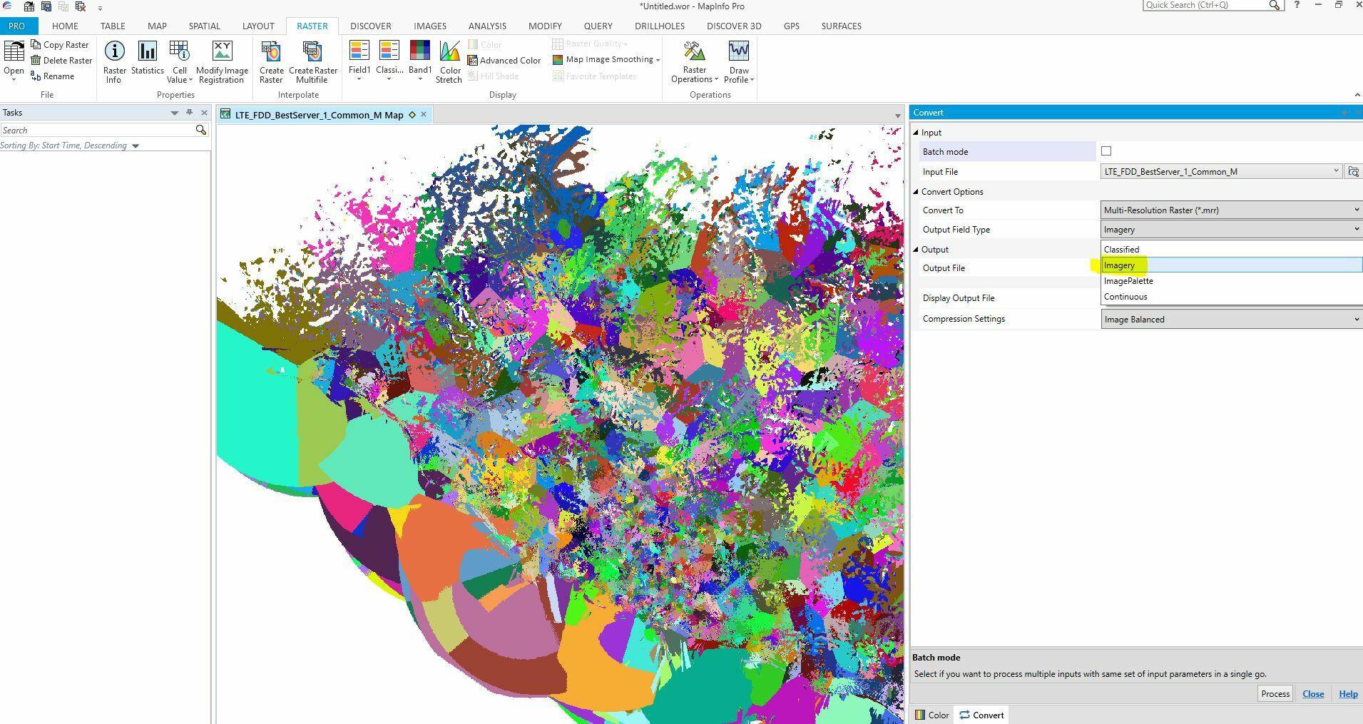
But, I find another solution, I need to export to another type of .mrr format in MapInfo pro which is .mrr imagery.


planet_coverages_imagery 

Then, I can run the next process using FME


fme 

Hopefully, FME team can resolve the problem with .mrr (classified)


Thank You

Reply