Solved

Two X - y Values for each attribute


Badge

Hello All,

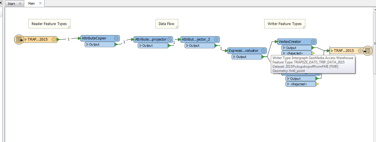
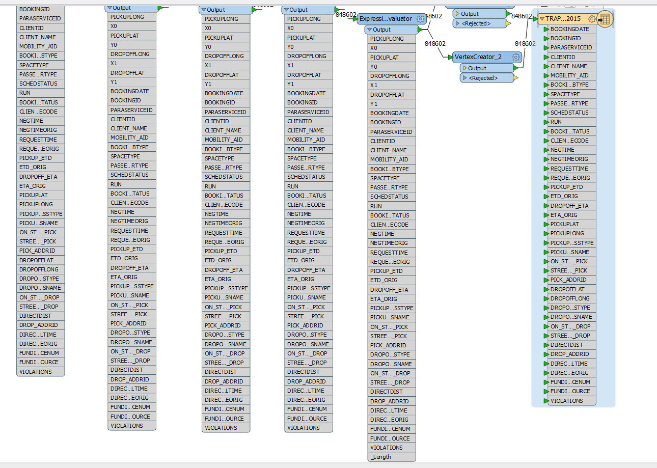
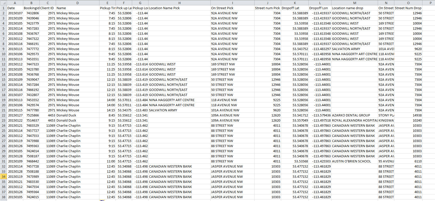
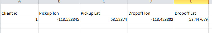
I have two X (Longitude) and Y (Latitude) values of each attribute. The first X & Y shows for the pickup location whereas the second one is for the drop off location. How can I get MITAB format file that shows pickup and dropoff in different colors? Also, I want to measure a direct distance between them. I tried AttributeProjector but it gives me only one x and Y attribute. Here is the sample of my data:

icon

Best answer by takashi 6 July 2016, 04:14

View original

10 replies

Userlevel 2
Badge +17

Hi @gsgoraya,

  • Distance calculation: You can use two AttributeReprojectors for 'pickup' and 'dropoff' and then calculate the length.
  • Colors: If you create two points (pickup and dropoff) for each record, you can set different colors to them.

e.g.

Badge

Hi @gsgoraya,

  • Distance calculation: You can use two AttributeReprojectors for 'pickup' and 'dropoff' and then calculate the length.
  • Colors: If you create two points (pickup and dropoff) for each record, you can set different colors to them.

e.g.

Thank you Takashi. It works for me. I really appreciate your help.

Gurpreet

Badge

Hi @gsgoraya,

  • Distance calculation: You can use two AttributeReprojectors for 'pickup' and 'dropoff' and then calculate the length.
  • Colors: If you create two points (pickup and dropoff) for each record, you can set different colors to them.

e.g.

Hello Takashi,

I tried to write on GeoMedia Warehouse, but seems to me it is not written accordingly. Here is the translation log:

Userlevel 2
Badge +17

Hello Takashi,

I tried to write on GeoMedia Warehouse, but seems to me it is not written accordingly. Here is the translation log:

Hi @gsgoraya, from the log, seems the Geometry parameter in the writer feature type is set to fm0_none, although the feature geometry is point. Try changing the parameter to fm0_point. In addition, the parameter setting for ExpressionEvaluator is not completed (the properties button is red). Set the math expression appropriately.

Badge

Hi @gsgoraya,

  • Distance calculation: You can use two AttributeReprojectors for 'pickup' and 'dropoff' and then calculate the length.
  • Colors: If you create two points (pickup and dropoff) for each record, you can set different colors to them.

e.g.

logfile.txt

Hello @

Takashi,

Thank you for the advise. I changed geometry from fm0_none to fm0_Point. The process is failing. I tried about 3 to 4 times but no luck. I have attached log file and expression couple other screenshots. Sorry to bother you.

Gurpreet

Userlevel 2
Badge +17

logfile.txt

0684Q00000ArMmeQAF.jpg

Hello @

0684Q00000ArMmjQAF.jpg

Takashi,

Thank you for the advise. I changed geometry from fm0_none to fm0_Point. The process is failing. I tried about 3 to 4 times but no luck. I have attached log file and expression couple other screenshots. Sorry to bother you.

Gurpreet

Hi @gsgoraya, according to this part of the log

GeoMedia Writer: Writing to Existing GeoMedia Warehouse version 5
Table TRAPEZE_DATS_TRIP_DATA_2015 exists, appending features...
GeoMedia Writer: Failed to determine Geometry field name for 'TRAPEZE_DATS_TRIP_DATA_2015' table
A fatal error has occurred. Check the logfile above for details 

I guess that the destination GeoMedia table exists and the schema of the table does not match the writer feature type configuration. If you will create a new table or overwrite the existing table in the destination GeoMedia dataset, try setting 'YES' to the 'Drop Table' parameter in the writer feature type.

Badge

Hi @gsgoraya, according to this part of the log

GeoMedia Writer: Writing to Existing GeoMedia Warehouse version 5
Table TRAPEZE_DATS_TRIP_DATA_2015 exists, appending features...
GeoMedia Writer: Failed to determine Geometry field name for 'TRAPEZE_DATS_TRIP_DATA_2015' table
A fatal error has occurred. Check the logfile above for details 

I guess that the destination GeoMedia table exists and the schema of the table does not match the writer feature type configuration. If you will create a new table or overwrite the existing table in the destination GeoMedia dataset, try setting 'YES' to the 'Drop Table' parameter in the writer feature type.

@takashi, Thank you for all your help. I was able to write the file. 

Badge

Hi @gsgoraya, according to this part of the log

GeoMedia Writer: Writing to Existing GeoMedia Warehouse version 5
Table TRAPEZE_DATS_TRIP_DATA_2015 exists, appending features...
GeoMedia Writer: Failed to determine Geometry field name for 'TRAPEZE_DATS_TRIP_DATA_2015' table
A fatal error has occurred. Check the logfile above for details 

I guess that the destination GeoMedia table exists and the schema of the table does not match the writer feature type configuration. If you will create a new table or overwrite the existing table in the destination GeoMedia dataset, try setting 'YES' to the 'Drop Table' parameter in the writer feature type.

@takashi, sorry to bother you again. Can I change the pickup and drop off points' color and draw polylines between them in FME? Thank you in advance.

goraya

0684Q00000ArNUBQA3.jpg

Userlevel 2
Badge +17

logfile.txt

Hello @

Takashi,

Thank you for the advise. I changed geometry from fm0_none to fm0_Point. The process is failing. I tried about 3 to 4 times but no luck. I have attached log file and expression couple other screenshots. Sorry to bother you.

Gurpreet

Hi @gsgoraya,

  • You can use the FeatureColorSetter to change color for each point.
  • You can create a polyline - by connecting points using the PointConnector, - or by joining line segments using the LineJoiner. However, you cannot set different colors for individual vertices belonging to a single polyline.

Which points should be connected to form a polyline?

Badge

Hi @gsgoraya,

  • You can use the FeatureColorSetter to change color for each point.
  • You can create a polyline - by connecting points using the PointConnector, - or by joining line segments using the LineJoiner. However, you cannot set different colors for individual vertices belonging to a single polyline.

Which points should be connected to form a polyline?

Hi @takashi , thank you for your response. As you see in the sample spreadsheet, every row has unique bookingid. I want to create polylines between the pickup and dropoffs. So I can see the trend where these persons were picked up and where did they go. That is why I also want to label all pick up with one color and the drop off with the other color. Let me know if you have any other questions. Thanks

Goraya

Reply