Question

Georeferencing Multidimensional Raster with different resolutions

  • 14 January 2020
  • 8 replies
  • 14 views

Badge

I'm bringing in several multidimensional GRIB files with which I would like to separate out each band for subsequent analysis. The GRIB file has several bands with inconsistent resolutions (i.e. 2880x1441 or 1440x721). When I run the GRIB file through a RasterBandSeparator, I see the following warning in the log file:

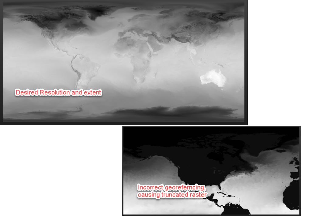
|WARN |GRIB reader: Band 17 of GRIB dataset is 1440x721, while the first band and dataset is 2880x1441. Georeferencing of band 17 may be incorrect, and data access may be incomplete.

The inconsistency in resolution results in incorrect georeferencing of the grids, in which the bands that have a resolution that differs from the first band are truncated and stretched.

Is there a way to prevent the system from using the resolution of the first band for georeferencing all other bands? Is there a known workflow for rectifying this behavior?


8 replies

Badge +2

hmm... not sure, but maybe you have to extract then the properties from each band and use that to resample each band again? But maybe that's not possible because you've already lost some data with splitting the bands to sperate rasters.


An

other option could be the use of the RasterBandKeeper or RasterBandRemover and looping through the raster?

Badge +22

Do you get the warning on the grib reader generally (even if you don't use the RasterBandSeparator)?


If not, then you could probably get the bounds of the image, and then use a RasterGeoreferencer to reset the georeferencing for the problem bands.
Badge

Do you get the warning on the grib reader generally (even if you don't use the RasterBandSeparator)?


If not, then you could probably get the bounds of the image, and then use a RasterGeoreferencer to reset the georeferencing for the problem bands.

Thanks for the suggestion!

To confirm, I do not get the warning generally - only when using the RasterBandSeparator. Unfortunately, placing a RasterGeoreferencer before or after the band separator does not solve the issue.

Badge

hmm... not sure, but maybe you have to extract then the properties from each band and use that to resample each band again? But maybe that's not possible because you've already lost some data with splitting the bands to sperate rasters.


An

other option could be the use of the RasterBandKeeper or RasterBandRemover and looping through the raster?

Unfortunately, it doesn't appear that I can extract the properties of each band prior to separating the bands. When I run the RasterPropertyExtractor on the GRIB file, I only get the properties of the first band.

Badge +22

Unfortunately, it doesn't appear that I can extract the properties of each band prior to separating the bands. When I run the RasterPropertyExtractor on the GRIB file, I only get the properties of the first band.

To get the band information you need to use the RasterBandPropertyExtractor, not the RasterPropertyExtractor

Badge +2

@jmcc01 : did you made any progress so far?

Badge

@jmcc01 : did you made any progress so far?

@harmen_kampinga Unfortunately, I'm still unable to resolve this issue. I've reworked my job to just use the PointOnRasterValueExtractor rather than separating out the bands. I'm still getting warnings of bands having different resolutions and, again, having incorrect values extracted.

I've tried using the RasterResampler as well, but still coming up with incorrect values.

My next test is to convert the GRIB files into NetCDF and see if that could resolve the issue -- doubtful, but worth a try. Otherwise, I'll have to investigate options outside of FME.

Badge +2

@harmen_kampinga Unfortunately, I'm still unable to resolve this issue. I've reworked my job to just use the PointOnRasterValueExtractor rather than separating out the bands. I'm still getting warnings of bands having different resolutions and, again, having incorrect values extracted.

I've tried using the RasterResampler as well, but still coming up with incorrect values.

My next test is to convert the GRIB files into NetCDF and see if that could resolve the issue -- doubtful, but worth a try. Otherwise, I'll have to investigate options outside of FME.

Sorry to hear that. Well, it's worth trying! All the best with it!

Reply