Question

Issue viewing data in ArcPro/ArcMap written with FME

  • 8 August 2019
  • 3 replies
  • 9 views

Hi all,

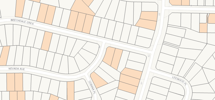
I am having issues viewing spatial data outputs in ArcPro or ArcMap. FME successfully writes all features to either feature class or shapefile (tried both) but when I open the data in Esri many of the features are not displayed. This doesn't happen all the time, but its been an issue with multiple workbenches all doing different things. When I add the result layer to Map/Pro the correct number of features show in the attribute table but the 'problem features' have the following issues

  • Fill symbology not applied, only outline symbology (i.e.
  • Problem features not selectable with "Select By Attributes" tool
  • Problem feature only selectable using select tool if the selection box cross feature outline


The image below shows layer results right after adding to ArcPro. Copying the feature class either by catalog or copy features tool does not resolve issue, but running a tool like buffer with 1cm seems to fix it.


Any ideas? Much appreciated!


3 replies

Userlevel 4
Badge +25

It kinda sounds like you're expecting areas to come out but get lines. There's a few things to check:

  • What does it look like in the FME Data Inspector?
  • What are you doing in the workspace? Any chance you are changing geometry types? (ESRI formats don't really like that)

Thanks for your comment. This led me to investigate the shape geometry a bit closer. I have just noticed. all the Shape_Area fields are wrong (not just the problem features, but all of them). If I run a buffer in ArcPro with a buffer dist of 1cm the correct area gets calculated and all features display correctly.

Im not doing anything particularly tricky in the workspace. Merging attributes on parcel ID then a few standard transformers like clipper, sorter, aggregator. The last thing I do is join the features back to the original Parcel data based on ID which is unnecessary but I was hoping to eliminate any bad geometries that might have been created.

In the FME data inspector the data looks as expected. (Image 1). Image 2 shows the same data viewed in Pro.

Data in FME Data Inspector

Data in ArcPro

Userlevel 4
Badge +25

Thanks for your comment. This led me to investigate the shape geometry a bit closer. I have just noticed. all the Shape_Area fields are wrong (not just the problem features, but all of them). If I run a buffer in ArcPro with a buffer dist of 1cm the correct area gets calculated and all features display correctly.

Im not doing anything particularly tricky in the workspace. Merging attributes on parcel ID then a few standard transformers like clipper, sorter, aggregator. The last thing I do is join the features back to the original Parcel data based on ID which is unnecessary but I was hoping to eliminate any bad geometries that might have been created.

In the FME data inspector the data looks as expected. (Image 1). Image 2 shows the same data viewed in Pro.

Data in FME Data Inspector

Data in ArcPro

Any chance you can share a small sample of the data, both before and after translation?

Reply