
In FME there is not a transformation method for transforming between EPSG:31467 and EPSG:25832. The Transformation file is defined here:
http://www.adv-online.de/Geodaetische-Grundlagen/T...
Could anyone tell me how to use this withini FME?

In FME there is not a transformation method for transforming between EPSG:31467 and EPSG:25832. The Transformation file is defined here:
http://www.adv-online.de/Geodaetische-Grundlagen/T...
Could anyone tell me how to use this withini FME?


Have you looked at the CsMapReprojector?
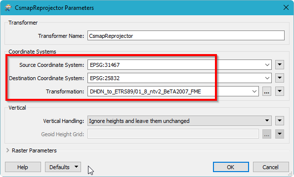
Note that you need to enter both the Source and Destination coordinate systems first before the Transformation dropdown populates itself.
OK....in principle everything works...but the problem remains, that ArcGIS can´t read the Coordinate information. Is it not possible to use the same naming conventions so that when a coordinate system is set, all software can understand which is defined? After using the Transformer, ArcGIS displays the geometries correctly, but reports unknown spatial reference.
OK....in principle everything works...but the problem remains, that ArcGIS can´t read the Coordinate information. Is it not possible to use the same naming conventions so that when a coordinate system is set, all software can understand which is defined? After using the Transformer, ArcGIS displays the geometries correctly, but reports unknown spatial reference.
Sorry, I can't help with that. Unless anyone else can chime in, it sounds like a question for Safe support: https://support.safe.com/knowledgeSubmitCase?
Send them a sample workspace with some input data and they'll probably find a solution for you.
Enter your username or e-mail address. We'll send you an e-mail with instructions to reset your password.
