
I am trying to create 3d block of the point cloud extents and not really getting anywhere. I was wondering if anyone would be able to help me in achieving this
Thanks,
Sam
Best answer by redgeographics
View original
I am trying to create 3d block of the point cloud extents and not really getting anywhere. I was wondering if anyone would be able to help me in achieving this
Thanks,
Sam
Best answer by redgeographics
View original

 +25
+25
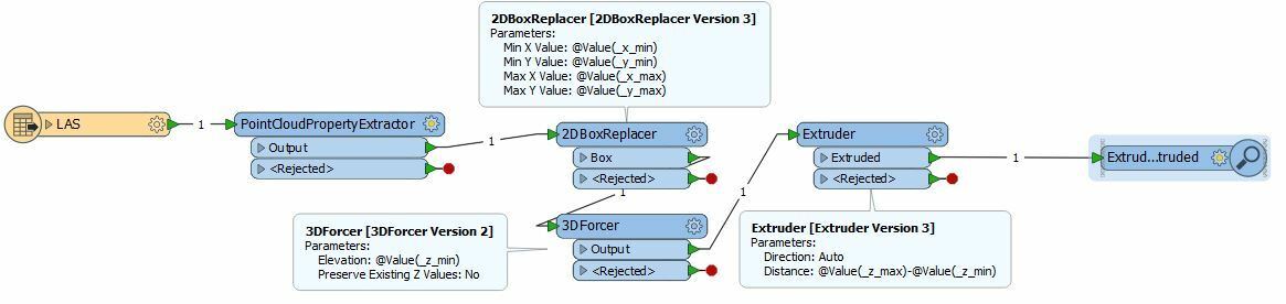
You can use a PointCloudPropertyExtractor to get the min/max x,y and z values. Then a 2DBoxReplacer to create the 2D bounding box from the min/max x and y, a 3DForcer to set that to the min z value and an Extruder to extrude it to max z - min z
Hope this helps.
You can use a PointCloudPropertyExtractor to get the min/max x,y and z values. Then a 2DBoxReplacer to create the 2D bounding box from the min/max x and y, a 3DForcer to set that to the min z value and an Extruder to extrude it to max z - min z
Hope this helps.
That's does the job perfect thanks! How would I go about using this with multiple files for the input to create one dgn file that has all these individual blocks in?
+25
That's does the job perfect thanks! How would I go about using this with multiple files for the input to create one dgn file that has all these individual blocks in?
You can use a PointCloudPropertyExtractor to get the min/max x,y and z values. Then a 2DBoxReplacer to create the 2D bounding box from the min/max x and y, a 3DForcer to set that to the min z value and an Extruder to extrude it to max z - min z
Hope this helps.
You can use a PointCloudPropertyExtractor to get the min/max x,y and z values. Then a 2DBoxReplacer to create the 2D bounding box from the min/max x and y, a 3DForcer to set that to the min z value and an Extruder to extrude it to max z - min z
Hope this helps.
Enter your username or e-mail address. We'll send you an e-mail with instructions to reset your password.
