Question

Creating a PDF map of a GeoDB point with WMS map imagery

  • 29 October 2019
  • 2 replies
  • 11 views

Badge

Hi all,

I am trying to create PDF maps which show points and areas from a Geodatabase, overlaid on imagery from a WMS connection. Each image in the PDF needs to show the point from the GeoDB at its centre, and be zoomed to a uniform distance so that the areas from the GeoDB and WMS imagery are visible.

Can anyone tell me where I need to start? I've made several attempts with a few different transformers, and I'm getting nowhere.

Thanks in advance!


2 replies

Userlevel 5
Badge +25

A few tips I can give you:

  • Create a box around the point or area (2DBoxReplacer for a point, BoundingBoxReplacer) and use that to query the WMS through a FeatureReader
  • Put everything in to the same input port of a PDFPageFormatter so it ends up in the same coordinate space.
  • If I recall correctly you need to make sure stuff enters in the right order, or is on the right layer (which in turn are in the right order), you can manually assign attributes for that and use a Sorter, or use the pdf_layer_name attribute.

Can you share what you have done so far? That'll probably help us get you closer to what you want.

Badge

A few tips I can give you:

  • Create a box around the point or area (2DBoxReplacer for a point, BoundingBoxReplacer) and use that to query the WMS through a FeatureReader
  • Put everything in to the same input port of a PDFPageFormatter so it ends up in the same coordinate space.
  • If I recall correctly you need to make sure stuff enters in the right order, or is on the right layer (which in turn are in the right order), you can manually assign attributes for that and use a Sorter, or use the pdf_layer_name attribute.

Can you share what you have done so far? That'll probably help us get you closer to what you want.

I've tried to simplify the workflow, and currently it looks like this:

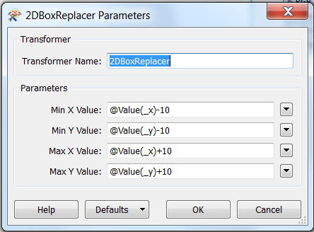
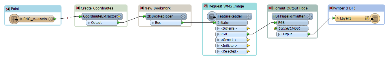
The input is a single point from a GeoDB, which I've run through a CoordinateExtractor to get the X Y value. As suggested, I've then used a 2DBoxReplacer with +10 and -10 added to the point X Y values to create an area:

I've then run this through the FeatureReader with the WMS details included as follows:

I've given it the following attributes:


I've then run it through the PDFPageFormatter as a single output:

Finally, I've written it to a PDF2D Writer. Unfortunately, this workspace doesn't get past the FeatureReader when I run it. I'm not totally sure which output from the FeatureReader I am expecting the matched image to come from? A new feature type was populated for RGB, but this does not work.

Reply