Solved

How to include layer/table ID for a feature type in ArcGIS Server Feature Service reader


Badge +8

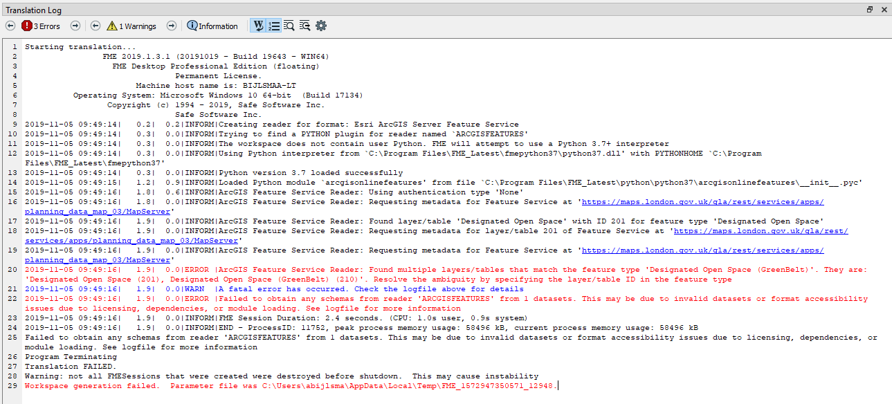
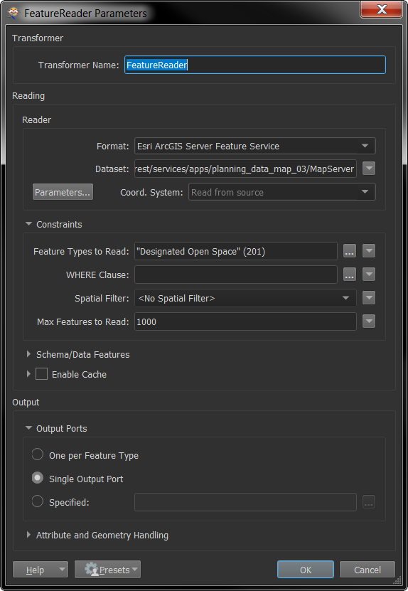
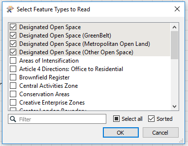
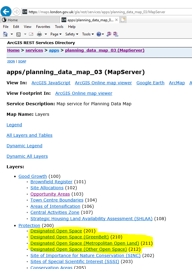
I am trying to add an ArcGIS Server Feature Service reader to my workspace. I just need one of the layers from the service. Several of the layers have the same name but are differentiated by their parent layer (which are scale dependencies). FME Desktop Help claims it shouldn't be a problem, stating "The reader resolves ambiguity by appending the layer ID to the end of feature types if multiple layers share the same name. If a layer ID is present in the feature type, the ID takes precedence over the name." That doesn't appear to be happening because I receive the following when I select my desired layer and try to add it: "ArcGIS Feature Service Reader: Found multiple layers/tables that match the feature type 'Stations, PNM (4)'. They are: 'Stations (4), Stations (10), Stations (16), Stations (22), Stations (28), Stations (34), Stations (40)'. Resolve the ambiguity by specifying the layer/table ID in the feature type." Ok, but how? I do so in other applications by adding a slash and the layer ID to the end of the URL but that doesn't work in FME. I haven't found any examples to show me the way, either here or in the desktop help. Anybody have the answer?

Thanks,

Aaron

icon

Best answer by trentatsafe 12 June 2018, 21:20

View original

11 replies

Badge +10

You could try to read the features through an HTTPCaller. You can point to the specific layer. You'll only need to create features from the output using JSON-transformers. I once created a blog about how to do such things for ArcGIS Online, but it works for ArcGIS Server as well.

You can find the blog here.

Badge +6

Hello @aaron,

I believe the issue here was as a result of a bug, that has since been addressed. If you are able to upgrade to either the last official release of 2016 or upgrade to FME 2018, I suspect this issue has been addressed.


FME 2016 and FME 2018.0 can be found through this page: https://www.safe.com/support/support-resources/fme-downloads/


If that does not solve the issue, please don't hesitate to reach out again!
Badge +8

Hello @aaron,

I believe the issue here was as a result of a bug, that has since been addressed. If you are able to upgrade to either the last official release of 2016 or upgrade to FME 2018, I suspect this issue has been addressed.


FME 2016 and FME 2018.0 can be found through this page: https://www.safe.com/support/support-resources/fme-downloads/


If that does not solve the issue, please don't hesitate to reach out again!
You are correct @trentatsafe. I tested in FME 2018 and the reader added the layer as expected. Thanks!
Badge +3

Hello @aaron,

I believe the issue here was as a result of a bug, that has since been addressed. If you are able to upgrade to either the last official release of 2016 or upgrade to FME 2018, I suspect this issue has been addressed.


FME 2016 and FME 2018.0 can be found through this page: https://www.safe.com/support/support-resources/fme-downloads/


If that does not solve the issue, please don't hesitate to reach out again!

Maybe I should log a different call, but at the same time don't want to create any duplication. I am trying to read all the layers using an Esri ArcGIS Server Feature Service reader, but getting exactly the same error as @aaron, yet I am using FME Desktop 2019.0 and 2020.beta:

https://maps.london.gov.uk/gla/rest/services/apps/planning_data_map_03/MapServer

Has the bug returned, or is this a different issue?

Badge +6

Maybe I should log a different call, but at the same time don't want to create any duplication. I am trying to read all the layers using an Esri ArcGIS Server Feature Service reader, but getting exactly the same error as @aaron, yet I am using FME Desktop 2019.0 and 2020.beta:

https://maps.london.gov.uk/gla/rest/services/apps/planning_data_map_03/MapServer

Has the bug returned, or is this a different issue?

Hi @arnold_bijlsma,

I tried the above URL in the ArcGIS Server Feature Service Reader and was able to successfully read the following features: Areas of Intensification, Article 4 Directions: Office to Residential, and Brownfield Register. This was tested in B19643 2019.1.


Which build of 2020.0 did you try? Are you able to try the latest 2019.1?
Badge +3

Hi @arnold_bijlsma,

I tried the above URL in the ArcGIS Server Feature Service Reader and was able to successfully read the following features: Areas of Intensification, Article 4 Directions: Office to Residential, and Brownfield Register. This was tested in B19643 2019.1.


Which build of 2020.0 did you try? Are you able to try the latest 2019.1?

Thanks for looking into this. It's the Designated Open Space ones that cause me issues, using B19643. I presume it could be something to do with the name difference being within the brackets...?:

PS: I can log a different call if this is something different

Userlevel 6
Badge +32

Thanks for looking into this. It's the Designated Open Space ones that cause me issues, using B19643. I presume it could be something to do with the name difference being within the brackets...?:

PS: I can log a different call if this is something different

Works for me with a FeatureReader and Single Output Port. When I switch to "One per Feature Type" I can reproduce the errors.

sample.fmwt

Badge +3

Works for me with a FeatureReader and Single Output Port. When I switch to "One per Feature Type" I can reproduce the errors.

sample.fmwt

It's the second, third and fourth Designated Open Space datasets that are falling over

Userlevel 6
Badge +32

It's the second, third and fourth Designated Open Space datasets that are falling over

0684Q00000ArNZSQA3.png

Ah, try the following values for Feature Types to Read:

"Designated Open Space (201)" "Designated Open Space (GreenBelt) (201)" "Designated Open Space (Metropolitan Open Land) (201)" "Designated Open Space (Other Open Space) (201)"
Badge +3

Ah, try the following values for Feature Types to Read:

"Designated Open Space (201)" "Designated Open Space (GreenBelt) (201)" "Designated Open Space (Metropolitan Open Land) (201)" "Designated Open Space (Other Open Space) (201)"

That worked using a FeatureReader, and also works if I manually manipulate the Layer List on the normal Reader. Excellent! However, they should not all have had (201) as suffix, but (201), (210), (211) and (212):

"Designated Open Space (201)" "Designated Open Space (GreenBelt) (210)" "Designated Open Space (Metropolitan Open Land) (211)" "Designated Open Space (Other Open Space) (212)"

For my future self and anyone else coming across this thread: you can get the layer name with the layer ID by opening the MapServer link in your internet browser:

0684Q00000ArNdiQAF.png


@trentatsafe: Going back to the original question at the very top of this page: Isn't this pretty much the same problem that you said was fixed? And is this the recommended solution: manually manipulating the layer list by appending the layer IDs?

Badge +3

Hello @aaron,

I believe the issue here was as a result of a bug, that has since been addressed. If you are able to upgrade to either the last official release of 2016 or upgrade to FME 2018, I suspect this issue has been addressed.


FME 2016 and FME 2018.0 can be found through this page: https://www.safe.com/support/support-resources/fme-downloads/


If that does not solve the issue, please don't hesitate to reach out again!

I am experiencing the same issue using the latest FME Desktop build:


FME(R) 2022.2.4.0 (20230303 - Build 22792 - WIN64) 

Reply